
As my colleague and ‘scientific counterpart’ Rennan Lemos, responsible together with our PI for Work Package 2 (The Variability of Funerary Monuments), pointed out so perfectly in his blog entry On the footsteps of Vila and the archaeology of monumental surveys in northern Sudan, a number of different factors determine how we have to approach our engagement with the past today. Not only do we archaeologists have to keep in mind our own social or cultural conditioning, our own socialisation, which is always an on-going process, but we also have to take into account the zeitgeist of our predecessors, and thus the working methods influenced by it, when we include their previous results.
In this regard, the method that Vila and his team applied for their Archaeological Survey in the 1970ies, which also covered the MUAFS concession area from Attab to Ferka, is equally relevant for settlement sites and thus for Work Package 1 (The Variability of Domestic Architecture).
Although Vila and his team also followed up on earlier surveys in Sudan, they deliberately chose an approach that was kind of new for their time. Their main aim was to give an idea and thus evidence of the cultural legacy, to raise awareness of the archaeological value of the explored regions. Linked to that was the explicit wish to pave the way for further fieldwork in the future.
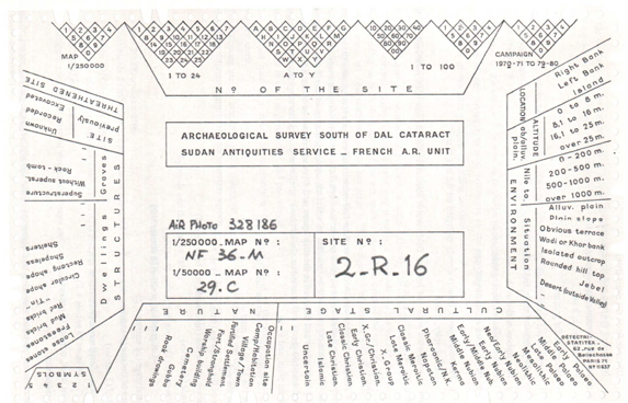
Concerning the settlements, in slight contrast to the cemeteries, where clearing or minor excavations were carried out more frequently, the major rule was that survey work must avoid disturbing the original condition of the archaeological sites. Instead of using invasive methods that would have resulted in significant destruction, (in most cases) work was limited to indicating the existence of the sites, documenting their visible remains and giving a current status report on them. The documentation system chosen by Vila and his team was based on a strict, predetermined catalogue of guidelines (Vila 1975, Volume I). Exemplarily mentioned shall be the given information about the localisation, the extent of the sites or the geographical features, and – in this point naturally somewhat more subjective – the classification of the respective archaeological value. The latter dictated quite decisively, f. ex. the extent of sampling, which was also subjected to strict rules. Another positive aspect to be highlighted is a topic usually rather neglected: The consistent application of the terms chosen for their survey (f. ex. vestiges for removable witnesses, like sherds or stone implements; remains for any kind of fixed structure) as well as the explanation of chosen terms like settlement, camp site, occupation site etc., and not least the description of the problems they were confronted with when creating their system.
Although Vila and his team likeable (and very well understandable for any field archaeologist) admitted their own hardships in this approach, having to leave to other people what they discovered, it is especially this transparency that makes it particularly helpful for us subsequent scholars to comprehend the information they gained, documented and what they understood by it.
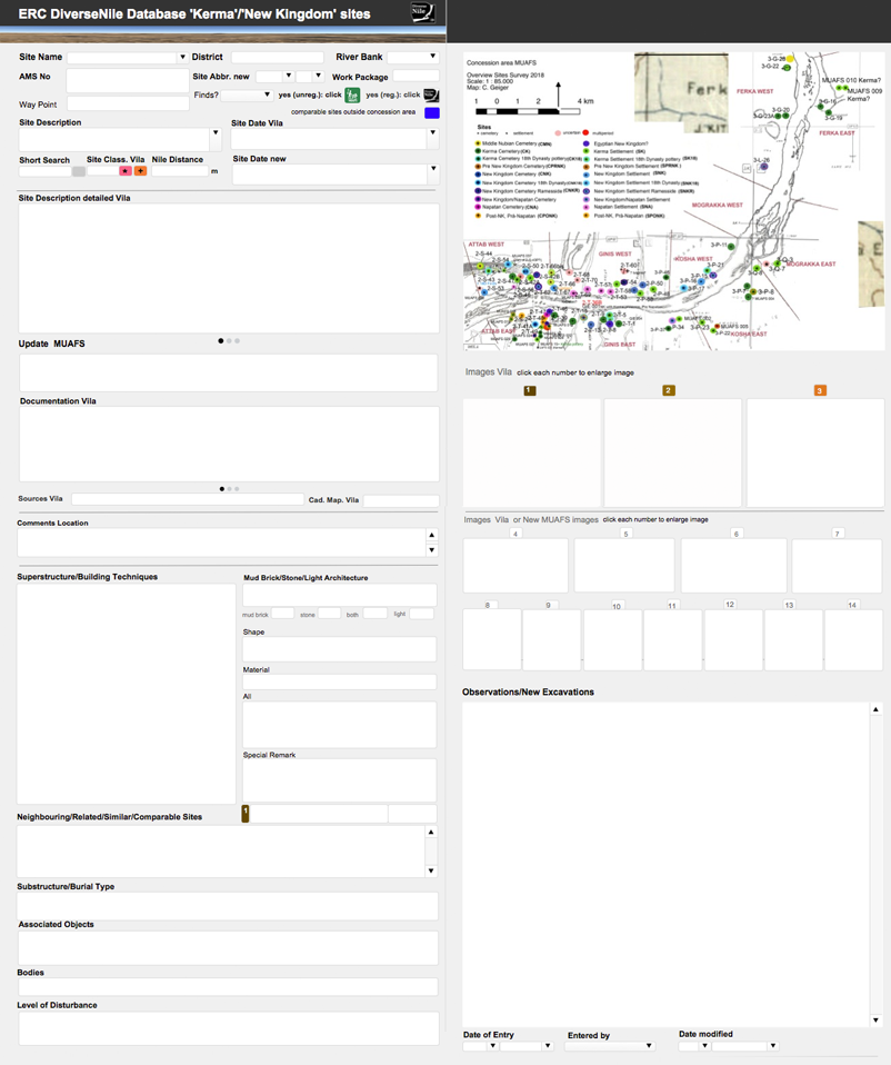
This systematics, which at that time was still applied in the field via punched cards created according to the guidelines and not unlike an analogue database (Fig. 1), enables the old survey results to be easily transferred to a now digital Database (FileMaker Pro), the ERC DiverseNile Database for ‘Kerma’ and ‘New Kingdom’ sites, I designed for Work Package 1 (see also the Petrographic Database my colleague Giulia D’Ercole designed for Work Package 3).
This new database contains on one hand all the available documentation published by Vila concerning the settlement sites, whereas the then state of research is contrasted in a clear and critical separation with the new data gained from our own studies, which includes f. ex. not only new sites, new maps, new photographs but also a revised dating for several dates given by Vila. As strongly intertwined topics it also includes basic information on cemeteries.
This easy to handle database, which I will give you here a short overview of, can be flexibly modified and adapted to the on-going work process (Fig. 2): Structured in three parts, the database first provides a short general information about the site, f. ex. its Name and location, the AMS-No (alphanumeric classification regarding the 1, 250 000 map sheets of the Sudan Survey Department, a method firstly implemented by W.Y. Adams 1961, further elaborated by F.W. Hinkel and used by Vila), or new Way Points (taken by the MUAFS team). Important entries are of course the site’s Dating given by Vila, which has been updated if necessary (Site Date new). The second, more detailed part includes the elaborated Site description by Vila together with already published photos, drawings or sketches, again updated and compared with new results collected in our last seasons (f. ex. Observation/New Excavations). The third section serves to cover specific data relevant for the settlements within Work Package 1, such as f. ex. Superstructure or Building Techniques, as well as entries like Shape or Material.
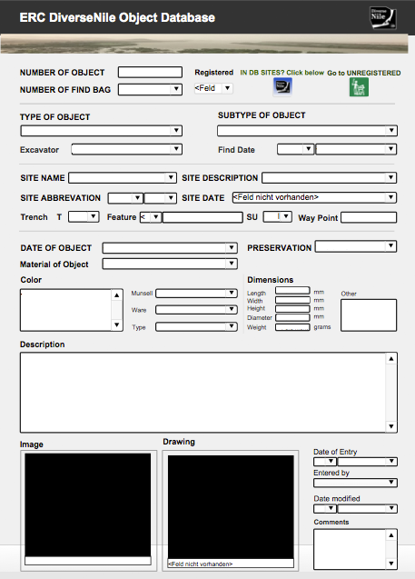
An equally beneficial option within FileMaker is the integration of other databases I made, the ERC DiverseNile Object Database (Fig. 3) and the MUAFS All Finds Database, which contain the data of all the new finds we so far recorded and are accessible through an easy command.
Altogether these databases are an extremely helpful and time-saving working tool to sort and select relevant data at a glance (or a click), revealing not only the wide variability of sites in our concession area but also the cultural diversity of the archaeological remains in the Attab to Ferka region, including at the moment 53 recorded sites relevant for Work Package 1.
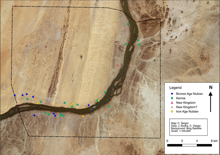
Being able to expand and optimise these databases during the work process, they also reflect at one glance the development of past and present research: This holds f. ex. true for the attribution of sites indicated by Vila as either ‘Kerma’ or ‘Egyptian New Kingdom’, defining them then still as more rigid cultural units, than we do today. Numerous data from revisited sites and newly added ones show a much closer interconnection of cultures in this region – thus supporting our new approach to move away from these strict categories and going a step further, with our PI introducing the preliminary term Bronze Age Nubia as a starting point (Fig. 4). Provided with newer methods in archaeology and fresh promising data we are looking forward to further shedding light on this flourishing and dynamic region in the periphery of Sai and Amara West.
References
Adams, W. Y. and Verwers C. J. 1961. ‘Archaeological Survey of Sudanese Nubia’. Kush 9, 7–43.
Budka, J. 2019 (with contributions by G. D’Ercole, C. Geiger, V. Hinterhuber and M. Scheiblecker). Towards Middle Nile Biographies: the Munich University Attab to Ferka Survey Project 2018/2019. Sudan & Nubia 23, 13–26.
Hinkel, F.W. 1977. The Archaeological Map of the Sudan. A Guide to its Use and Explanation of its Principles. Berlin.
Vila. A. 1975. La prospection archéologique de la vallée du Nil au sud de la Cataracte de Dal. Vol. 1. Paris.