I’ve just got back from a really intense month of fieldwork in Sudan.
Our field season was from 5th March to 2nd April 2026. As well as Dr. Mohamed Eltoum (NCAM inspector), our team was joined for a few days by Mohammed Abbas (NCAM Jebel Barkal, drone pilot), Abd el-Magid Mahmoud Abd el-Rahman (NCAM Dongola) and Majhoub Ebrahim (drone pilot). Also, Huda Magzoub, my former NCAM inspector, came by and was with us from 26th March to 2nd April. We stayed in our dig house in Ginis and we’re really grateful to Mr Mohammed Khater Bashir, who was a great cook, and Mr Magzoub Hassan Mohammed, who was a great driver and head of logistics. We’d also like to say a big thank you to our workman and boatman Sameer Ali Saleh and our workman and police officer Mohammed Osman.
Mohammed Eltoum, Sameer and I are heading over to the west bank (photo: M. Eltoum)Mahjoub is operating his DJI Mavic 2 Pro drone.Mahjoub is recording for his video about our work in Attab and Ginis (photo: M. Eltoum)
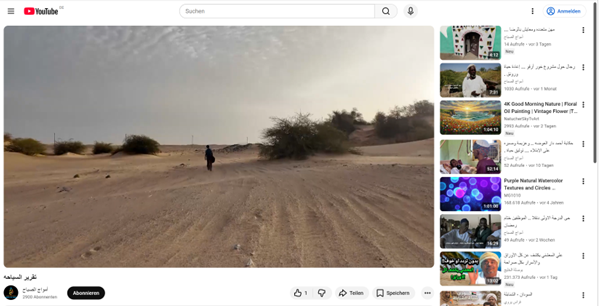
Thanks to Majhoub Ebrahim, we’ve got a short video about our work in Attab and Ginis. It was shown on Sudanese TV and is now available on the YouTube channel of Amwaj Al-Sabah Media Services.
There are two main things we wanted to get across: first, northern Sudan is safe for foreigners to work and second, especially in these challenging times of war and increased illegal gold mining, it’s really important that international missions work together with the local authorities to protect the rich cultural heritage of Sudan.
I’m really thankful that, with my friends and colleagues from NCAM, we managed to put on such a successful season, even though things are still tough in Sudan.
A while ago, I had the great pleasure of being interviewed for the ÖAW podcast “Hiccup: Through Time with a Hiccup”. This fantastic series invites academics to travel through different eras – from Ancient Egypt to the Byzantine Empire and on to the Early Modern Period. I myself chose the year 1454 BC on the Nile island of Sai in Upper Nubia – you can hear why in the podcast.
Today I had the wonderful opportunity to revisit the inscription of Nehi in Sai that was highlighted in the podcast. The whole experience was truly a lovely, nostalgic glimpse into the past – as I undertook the excursion with Sudanese friends and colleagues, particularly Huda Magzoub, who worked with me in Sai for many years.
Huda and I at the imposing stone block bearing Nehi’s inscription (photo: Mohammed Eltoum)
Especially in these difficult times in Sudan, where war still rages in parts of the country, this trip down memory lane is also, for me, a glimpse into the future – we will all work together again in Sudan and help to preserve the cultural world heritage.
There are many urgent tasks to be dealt with, and I am very grateful to be able to spend some time here in this beautiful country with its rich archaeology and wonderful people.
Greetings to all local and international colleagues working to protect Sudanese heritage and antiquities amidst the war in Sudan.
By Huda Magzoub Al-Bashir (Khartoum)
Protecting Archaeological Work and its Personnel in Times of War and Crisis
The Question of the Necessity of Archaeological Work in Times of War and Crisis
Archaeological work in times of war and crisis is not always necessary, but it can be important in some cases.
Importance of Archaeological Work in Times of War and Crisis:
1. Protecting Cultural Heritage: Archaeological teams can work to protect cultural heritage from destruction or looting.
2. Documenting Cultural Heritage: Archaeological teams can document cultural heritage before it is destroyed or looted.
3. Promoting Cultural Awareness: Archaeological teams can promote cultural awareness of the importance of cultural heritage.
Risks of Archaeological Work in Times of War and Crisis:
1. Risk of Injury or Death: Archaeological teams may face the risk of injury or death due to war and crisis.
2. Destruction of Archaeological Sites: Archaeological sites may be destroyed or looted due to war and crisis.
3. Difficulty Accessing Sites: It may be difficult to access archaeological sites due to war and crisis.
When should archaeological work be done in times of war and crisis?
1. When there is a risk to cultural heritage: If there is a risk to cultural heritage, archaeological teams should work to protect it.
2. When there is an opportunity to document cultural heritage: If there is an opportunity to document cultural heritage, archaeological teams should work on it.
3. When there is support from local authorities: If there is support from local authorities, archaeological teams should work to protect cultural heritage.
Ultimately, archaeological teams should assess the risks and benefits before deciding to work in times of war and crisis.
The security and academic role of archaeological work in Sudan in times of war and crisis is a vital and important topic. Sudan possesses a rich cultural heritage, but it faces significant challenges in protecting this heritage due to armed conflicts and the illicit trafficking of antiquities.
Security Role:
– Protecting archaeological sites from destruction and looting.
– Enhancing the security of museums and archaeological sites.
– Combating the trafficking of antiquities and cooperating with international organizations to recover looted artifacts.
Academic Role:
– Documenting archaeological sites and artifacts.
– Conducting archaeological research and studies to enhance understanding of Sudan’s cultural heritage.
– Promoting cultural awareness of the importance of archaeological heritage.
Challenges:
– Armed conflicts and illicit trafficking of antiquities.
– Lack of funding and technical expertise.
– Climate change and encroachment on archaeological sites.
Proposed Solutions:
– Enhancing international and regional cooperation to protect cultural heritage.
– Providing funding and technical expertise to enhance the security of archaeological sites.
– Launching awareness campaigns on the importance of cultural heritage.
It is essential that the Sudanese government, international organizations, and civil society work together to protect Sudan’s cultural heritage and promote awareness of its importance.
The collaboration between the Sudanese government, international organizations, academia, and civil society to protect Sudan’s cultural heritage in times of war and crisis has numerous benefits, including:
1. Enhancing cultural security: International and regional cooperation can help enhance the security of archaeological sites and museums, and prevent the trafficking of antiquities.
2. Providing funding and technical expertise: International organizations can provide the necessary funding and technical expertise to protect cultural heritage.
3. Promoting cultural awareness: Joint awareness campaigns can promote awareness of the importance of Sudan’s cultural heritage.
4. Protecting world heritage: Sudan possesses a rich cultural heritage, and international cooperation can help protect this heritage for the world.
5. Enhancing tourism: Cultural heritage can be an important source of tourism, and cooperation can help promote cultural tourism.
6. Enhancing regional cooperation: Cooperation in protecting cultural heritage can enhance regional cooperation between Sudan and neighboring countries.
7. Protecting cultural identity: Cultural heritage is an important part of Sudan’s identity, and cooperation can help protect this identity.
Overall, collaboration between the Sudanese government, international organizations, and civil society can play a significant role in protecting Sudan’s cultural heritage and promoting awareness of its importance.
The work of archaeological missions in Sudan in times of war and crisis has both benefits and risks:
Benefits:
1. Documenting cultural heritage: Archaeological missions can document archaeological sites and artifacts before they are destroyed or looted.
2. Protecting cultural heritage: Archaeological missions can help protect archaeological sites from destruction and looting.
3. Promoting cultural awareness: Archaeological missions can promote awareness of the importance of Sudan’s cultural heritage.
4. Training local staff: Archaeological missions can train local staff on methods of preserving cultural heritage.
5. Enhancing international cooperation: Archaeological missions can enhance international cooperation in the field of cultural heritage protection.
Risks:
1. Risk of destruction or looting: Archaeological sites may be vulnerable to destruction or looting due to war and crisis.
2. Risk of injury or death: Archaeological missions may face the risk of injury or death due to war and crisis.
3. Transfer of artifacts: War may lead to the transfer of artifacts abroad without the permission of the Sudanese authorities.
4. Deterioration of archaeological sites: War may cause deterioration of archaeological sites due to mishandling or lack of expertise.
Therefore, it is essential that archaeological missions in Sudan work in cooperation with the Sudanese authorities and international organizations, and follow necessary security and precautionary measures to protect Sudan’s cultural heritage.
The risk to archaeological mission personnel in Sudan in times of war is a vital and important topic. There are several risks facing archaeological mission personnel in Sudan, including:
1. Risk of injury or death: Archaeological missions may face the risk of injury or death due to war and crisis.
2. Kidnapping or detention: Archaeological mission personnel may be kidnapped or detained by armed groups.
3. Looting or theft of equipment: Equipment and tools used in archaeological missions may be looted or stolen.
4. Destruction of archaeological sites: Archaeological sites may be destroyed or looted due to war and crisis.
5. Difficulty accessing sites: It may be difficult to access archaeological sites due to war and crisis.
6. Lack of logistical support: There may be a lack of logistical support and resources necessary for archaeological missions.
7. Risk of disease: Archaeological mission personnel may be exposed to the risk of disease due to poor health conditions.
Therefore, it is essential that archaeological missions take precautionary and security measures to protect their personnel, such as:
1. Cooperating with local authorities: Working with local authorities and international organizations to ensure the safety of the mission.
2. Risk assessment: Assessing potential risks and taking necessary measures to mitigate them.
3. Providing logistical support: Providing logistical support and resources necessary for the mission.
4. Training personnel: Training personnel on security and precautionary procedures.
5. Continuous monitoring: Continuously monitoring the security situation and communicating with local authorities.
What are the responsible authorities for protecting global, international, and academic archaeological personnel in times of war and emergency?
There are several authorities responsible for protecting global, international, and academic archaeological personnel in times of war and emergency, including:
1. United Nations Educational, Scientific and Cultural Organization (UNESCO): UNESCO is the primary authority responsible for protecting world cultural heritage and provides support and assistance to archaeological personnel in times of war and emergency.
2. International Union of Academies: The International Union of Academies is an international organization that works to protect cultural heritage and promote international cooperation in the field of archaeology.
3. International Committee of the Red Cross and Red Crescent: The International Committee of the Red Cross and Red Crescent works to protect civilians, including archaeological personnel, in times of war and emergency.
4. International Atomic Energy Agency: The International Atomic Energy Agency works to protect cultural heritage from damage caused by nuclear radiation.
5. Non-Governmental Organizations: There are many non-governmental organizations that work to protect cultural heritage and archaeological personnel in times of war and emergency, such as BLAZ and Cultural Heritage in Danger.
6. Local Authorities: Local authorities in countries affected by war and emergency are responsible for protecting archaeological personnel and cultural heritage.
7. International Emergency Organizations: International emergency organizations such as Médecins Sans Frontières (MSF) and the International Committee of the Red Cross (ICRC) provide humanitarian assistance, including protection of archaeological personnel, in times of war and emergency.
These authorities work together to provide support and assistance to archaeological personnel in times of war and emergency, and to ensure the protection of cultural heritage.
Is it necessary for archaeological personnel to work in times of war and crisis?
Archaeological personnel working in times of war and crisis is not always necessary, but it can be important in some cases. Here are some points to consider:
Risks of archaeological work in times of war and crisis:
When should archaeological personnel work in times of war and crisis?
1. When there is a risk to cultural heritage: If there is a risk to cultural heritage, archaeological personnel should work to protect it.
2. When there is an opportunity to document cultural heritage: If there is an opportunity to document cultural heritage, archaeological personnel should work on it.
3. When there is support from local authorities: If there is support from local authorities, archaeological personnel should work to protect cultural heritage.
In conclusion, archaeological personnel should assess the risks and benefits before deciding to work in times of war and crisis.
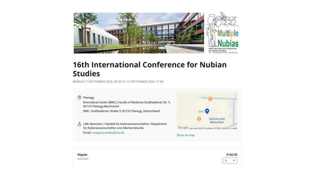
We would like to thank everyone who submitted proposals for oral and poster presentations. We currently have more than 260 presentations scheduled alongside posters which will be displayed throughout the conference. Please be advised that the provisional programme, which is now available on the conference website, is still subject to change.
The main theme of the Munich conference, Multiple Nubias, is linked to the latest research findings of the ERC DiverseNile project. New research is starting to show that ancient Sudan was a lot more diverse than we thought, and that there were actually several different forms of Nubia. This goes against the common idea that Nubia was just one single place in the past. So, we’ve invited in particular sessions and papers to look at different experiences, regional traditions and individual actors – both human and non-human – over the millennia. There will also be four keynote speeches that will look at the main theme of the conference from a diachronic perspective, employing a variety of methodological approaches.
In light of the ongoing situation in Sudan, particular emphasis will be placed on safeguarding and conserving cultural heritage, along with related initiatives and projects.
Please note that it is mandatory for all participants to register for the conference in order gain access. Online registration is now open, for details see https://nubianstudies2026.de/tickets/. Colleagues from Sudan and Egypt are entitled to complimentary tickets (free of charge). Due to the ongoing situation in Sudan, the conference will be a hybrid event.
We’re really looking forward to meeting all of you who are interested in Nubia and Sudan in Munich!
I’m delighted to announce that a new publication is now available in open access. Me and my co-authors – Fabian Dellefant, Giulia D’Ercole, H. Albert Gilg, Rosemarie Klemm and Johannes H. Sterba – show how archaeometric techniques used as part of the DiverseNile Project can be used to investigate human-environment interactions in the Middle Nile during the Bronze Age.
We present case studies from our recent investigation of landscape properties in the MUAFS concession area in northern Sudan, the Attab to Ferka region, and associated material remains. We also included some materials from Sai Island, the main urban site of this region. Our article looks at different ways to combine archaeology and geology, like taking rock samples and studying the composition of sandstones (see also an earlier blog post by Fabian). It also shows how these methods can be used to understand past landscapes and mobility patterns. We’re looking at the material culture, especially ceramics, in a bunch of different ways using a bunch of different scientific methods. We’re combining compositional bulk analysis (INAA) with mineralogical (XRD) and petrographic data via optical microscopy (OM) to check out the physical properties, where the ceramics came from and how they were made (you may want to check out an earlier blog post by Giulia). We’re also using Raman spectroscopy to see what temperatures the ceramics were fired at.
This paper shows how new developments in landscape archaeology and the archaeometry of material culture are helping us to understand the big ecological and social changes that happened in the Bronze Age Middle Nile. We think this combined analytical approach, which we’ve used in the Attab to Ferka region as an example, can also be successfully used in other regions around the world.
Full reference of the new publication:
Julia Budka, Fabian Dellefant, Giulia D’Ercole, H. Albert Gilg, Rosemarie Klemm & Johannes H. Sterba, Investigating human-environment interactions in the Middle Nile: The contribution of archaeometric techniques to understanding landscape use and social practices in Bronze Age Sudan, Egypt and the Levant 35, 2025, 101−134, https://austriaca.at/0xc1aa5572_0x00412ff6.pdf
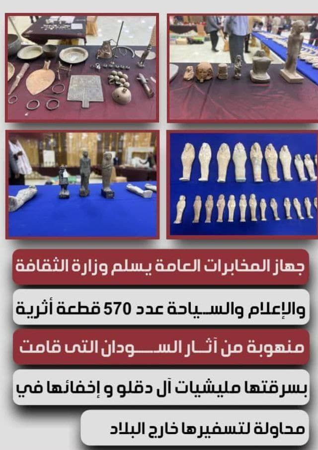
The Ministry of Culture, Information and Tourism of Sudan renews its announcement of a financial reward for anyone who returns artifacts or provides information on their whereabouts.
An open call to all citizens to contribute to protecting Sudan’s cultural heritage
Recovering looted artifacts is a victory for national identity and preservation of its memory
Press Office – Ministry of Culture, Information and Tourism Saturday, January 17, 2026
The Ministry of Culture, Information and Tourism announced the allocation of a financial reward for anyone who returns artifacts in their possession or provides accurate information on their whereabouts, as part of the state’s efforts to protect cultural heritage and recover looted Sudanese artifacts (see also this article).
This announcement comes days after the Minister of Culture, Information and Tourism, Mr. Khalid Al-Aiser, spoke in Port Sudan on Tuesday, January 13, 2026, during a ceremony to recover a large number of looted Sudanese artifacts, totaling 570 rare pieces, affirming that this step represents a victory for national identity and preservation of Sudan’s cultural memory.
The Minister said: „We extend a sincere and reassuring call to all citizens who have found or are keeping artifacts, that the state extends its trust and responsibility, and confirms that returning these artifacts through legal channels is a noble national act, contributing to protecting Sudan’s history and preserving its cultural memory, as a shared right that no individual owns, but is inherited by generations. We take this important national occasion to affirm the state’s commitment to incentivizing any citizen who returns artifacts in their possession or provides information on their whereabouts, with a financial reward in appreciation of their efforts.“
The Press Office, on behalf of the Ministry, renewed the announcement of the financial reward today, affirming the Ministry’s commitment to enhancing the protection of national heritage and encouraging community participation in preserving Sudan’s cultural heritage.
The Ministry confirmed that this initiative is part of efforts to strengthen community partnership, an open call to all citizens to contribute to protecting Sudan’s cultural heritage for future generations.
In a grand ceremony in Port Sudan, the seat of the Sudanese government since the outbreak of the Khartoum war, the General Intelligence Service handed over to the Ministry of Culture, Information and Tourism 570 looted archaeological pieces from Sudan’s heritage, which were stolen by militias and hidden in an attempt to smuggle them out of the country.
For Flooded Pasts, Carruthers did a really thorough review of the archival material produced during the famous UNESCO Nubian campaign. He says it’s clear that the archives we’re talking about are part of a (post)colonial context, where modern Nubian communities and their sites have been ignored in the past. The focus of the archives, archaeological investigations and historical narratives is exclusively on the ancient past, thus giving rise to the necessity of „repeopling Nubia“, the subtitle of the conclusion of the book (pp. 274–283).
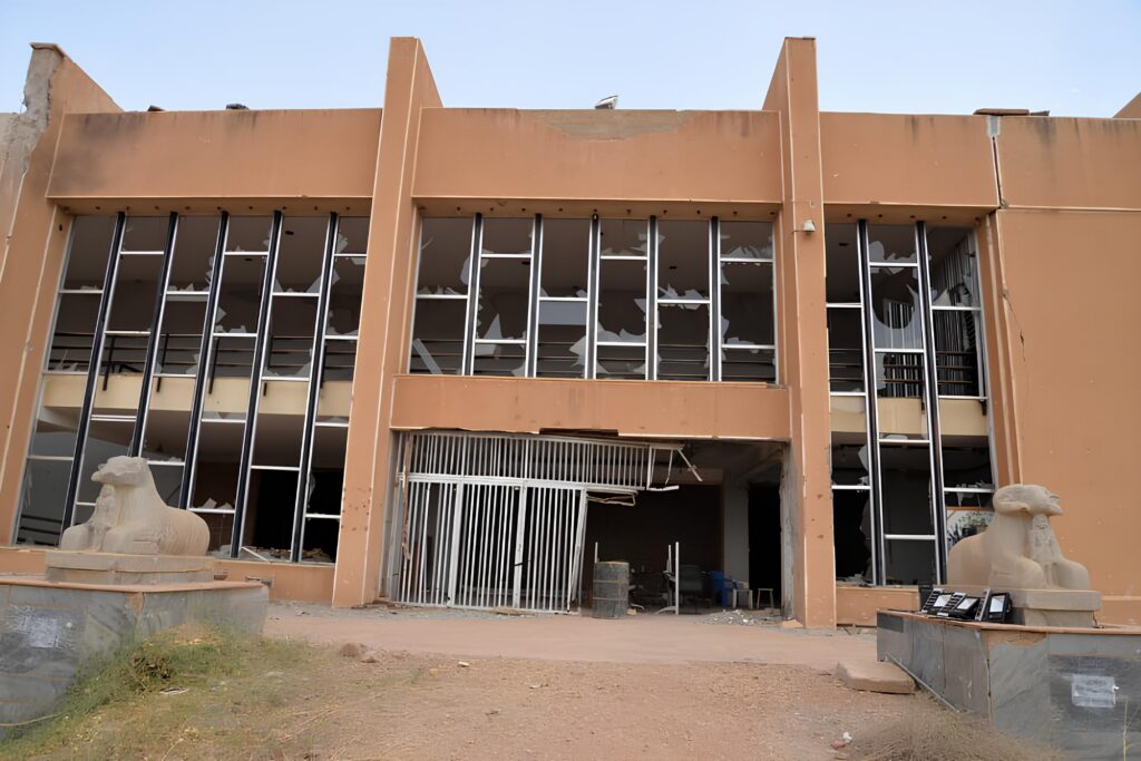
One result of the UNESCO campaign in Sudan was the opening of the National Museum in Khartoum on 25 May 1971. Even though its garden had temples from Aksha, Buhen, Semna East and Semna West, the museum and its collection weren’t given World Heritage status (unlike Egypt; check out the reviewed book for more on this, on pp. 239–241). Carruthers (p. 242) rightly puts this in context, pointing out that Sudan at the time was “a state in some degree of turmoil” (p. 242). It’s interesting that on page 241, above the heading “Forgetting Sudan?”, there’s a picture of the Sudan National Museum (Carruthers‘ Fig. 7.1). As with so much of Sudan’s cultural heritage, the museum has suffered destruction and looting in a ‚forgotten‘ war, which has been going on since 2023.
Destroyed front of the Sudan National Museum, 15 May 2025 (photo: National Corporation for Antiquities and Museums.
The current conflict in Sudan shows just how closely linked archaeology is to the society around it. The archaeology of Sudan is closely tied to the history of colonialism, and it’s been affected by different forms of exploitation and manipulation by governments and powerful groups who have used it to push their own national agendas. It’s clear that this is just as true today as it was in the past.
At the time of writing, Carruthers said that discussing the future of the Nubians was a tricky topic (p. 283). The war in Sudan has been going on since 2023 and has affected millions of people all over the country. This also shows why we should be interested in creating Nubian histories. It’s not just the institutions involved in the so-called Nubian campaign or archaeologists working in Sudan who should be interested, but everyone on a global level. There are new versions about the Nubian presence in Egypt, Sudan, the United States and other places that are still to be written! And these are anything but marginal.
As we said a few weeks ago at the UNESCO conference in Berlin, we’re never going to give up on Sudan! But we also need more people to talk about Sudan, to care about the Sudanese people and to help protect their rich cultural heritage.
With the festive season here in Europe and another awful war going on just next door, we should remember that millions of Sudanese people have lost everything and are struggling to survive. Sudan is the biggest humanitarian crisis of 2025, and we’re really hoping things will change in 2026.
Gartag (الجرتق) is a ceremonial rite of passage (marriage, birth, circumcision) symbolizing fertility, blessing, and protection. It is a traditional ritual involving wearing gold, red silk, applying henna to the limbs, and using specific types of traditional perfumes.
Gartag Details:
– Wearing Gold: Gold is considered a symbol of blessing and fertility.
– Red Silk: Symbolizes good luck and protection.
– Henna: Applied to the limbs for protection and blessing.
– Traditional Perfumes: Used to enhance the celebratory and spiritual atmosphere.
Example for Sudanese Henna in the context of Gartag (https://500wordsmag.com/wp-content/uploads/2022/10/Sudanese-Henna.jpg)
Importance of Gartag:
– Enhances the sense of joy and celebration.
– Connects individuals with their cultural traditions.
– Strengthens social and familial bonds.
Gartag is an important part of Sudanese heritage and remains a vibrant practice in many communities.
UNESCO Adds Sudanese „Gartag“ to Representative List of Intangible Cultural Heritage of Humanity
The Gartag was officially registered as an element of „practices, rituals, and expressions for preservation, protection, abundance, and fertility in Sudan“ on the Representative List. The file was prepared by the National Council for Cultural Heritage and Promotion of National Languages, Ministry of Culture, Information, and Tourism, in collaboration with the Heritage House Center, the Sudanese National Commission for UNESCO, and the UNESCO Office in Sudan. This followed the requirements of the 2003 Convention for the Safeguarding of Intangible Cultural Heritage, with broad participation from heritage-bearing communities across Sudan.
Gartag is one of the most important living Sudanese rituals, rich in symbols and meanings deeply rooted in popular culture, tracing back to the Meroe civilization. This ritual embodies values of abundance, fertility, blessings, and protection, combining material elements like gold, silk, henna, and traditional perfumes with social and spiritual meanings that strengthen family bonds and community cohesion.
The inscription of Gartag is the second international recognition of Sudanese heritage in recent years, following the inclusion of Mawlid celebrations on the Representative List in December 2023. This achievement comes at a time when Sudanese cultural heritage faces significant challenges due to war conditions, making this recognition even more important and boosting national efforts to protect it.
The Secretary-General of the National Council for Cultural Heritage and Promotion of National Languages emphasized that the registration of Gartag reflects the resilience of Sudanese communities and their attachment to their heritage. It is a pivotal step toward ensuring the transmission of this legacy to future generations as an integral part of Sudanese cultural identity and shared human memory.
The utilisation of animal dung and crop residue as a fertiliser and soil amendment is an ancient practice, dating back to antiquity. In many ancient civilizations, such as ancient Egypt and ancient China, people employed animal dung and crop residue to enhance soil quality and augment crop yields. In ancient Egypt, for instance, people used animal dung as a fertiliser for the soil, deeming it one of the finest natural fertilisers. They also utilized crop residue to improve soil quality and increase crop productivity. In ancient China, people used animal dung and crop residue as a fertiliser and soil amendment, considering it a fundamental fertiliser for enhancing soil quality and augmenting crop yields. In Sudan, the ancient Nubian civilization employed animal dung and crop residue as a fertiliser and soil amendment, regarding it as a natural fertiliser to improve soil quality and increase crop productivity. This ancient practice remains in use today in many parts of the world, where animal dung and crop residue are considered effective natural fertilisers for enhancing soil quality and augmenting crop yields.
The custom of utilising animal dung and crop residue as a fertiliser dates back to the Neolithic era, circa 10,000 years before present. In that epoch, mankind commenced agriculture and employed animal dung to ameliorate soil quality. In ancient Egypt, the utilization of animal dung as a fertiliser was prevalent since approximately 5,000 years before present, during the period of the Old Kingdom (2613-2181 BCE). In ancient China, the employment of animal dung as a fertiliser was widespread since circa 4,000 years before the Common Era, during the era of Shamanic faith (1600-1046 BCE). In Sudan, the ancient Nubian civilization utilized animal dung as a fertiliser since approximately 2,000 years before present, during the reign of the Kingdom of Kush (1070 BCE – 350 CE). This ancient practice has endured unto the present day, wherein animal dung and crop residue are esteemed as efficacious natural fertilisers for enhancing soil quality and augmenting crop yields.
Verily, animal dung and crop residue are employed as a fertiliser in diverse regions of the world, particularly in rural and agricultural areas. In Sudan, for instance, farmers utilise animal dung as a natural fertiliser to enhance soil quality and augment crop yields.
The regions wherein animal dung is utilised as a fertiliser are:
– Rural districts: where beasts are reared and their dung is used as a fertiliser for tillage.
– Agricultural regions: where animal dung is employed to ameliorate soil quality and increase crop productivity.
– Domestic gardens: where people use animal dung as a natural fertiliser to promote plant growth.
The types of animal dung used as a fertiliser are:
– Bovine dung: replete with nitrogen, phosphorus, and potassium.
– Galline dung: rich in nitrogen and phosphorus.
– Equine dung: abundant in nitrogen, phosphorus, and potassium.
– Ovine dung: endowed with nitrogen and phosphorus.
It is advisable to ensure that animal dung has been analysed and cleaned before it is used as fertiliser so that it does not damage plants or soil.