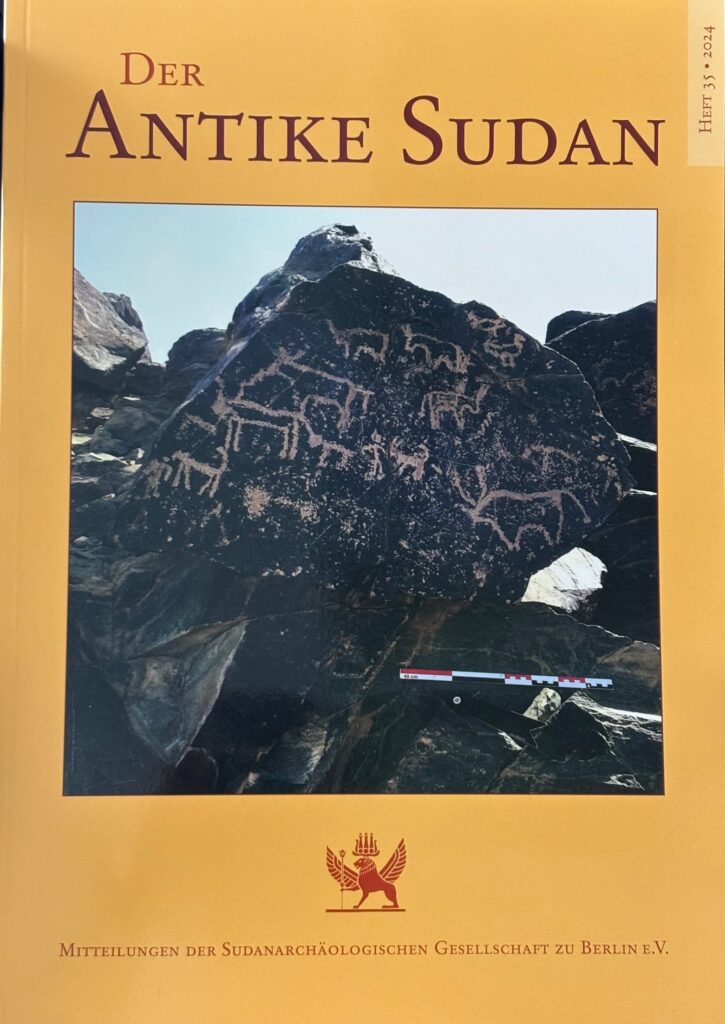
As rock art in Sudan continues to be one of my favourite research topics, I am very pleased that a new article of mine on the rock engravings of Kerma in the MUAFS concession has just been published and that one of the beautiful boulders with cattle depictions has also made it onto the front page of MittSAG 35!
In the paper “Cattle motifs in Nubian rock art of the Bronze Age – a preliminary update from Kosha, Mograkka and Ferka” (Budka 2024), my aim was to show the potential of the little-known rock art from the MUAFS concession, especially for the Kerma period. During this period, cattle motifs are particularly prevalent in rock art in Sudan.
Among other sites, I highlighted some aspects of the largest rock art cluster within the MUAFS concession, 3-P-5, located on the border between Mograkka and Kosha. This remarkable site comprises more than 400 individual rock carvings.
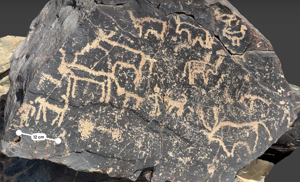
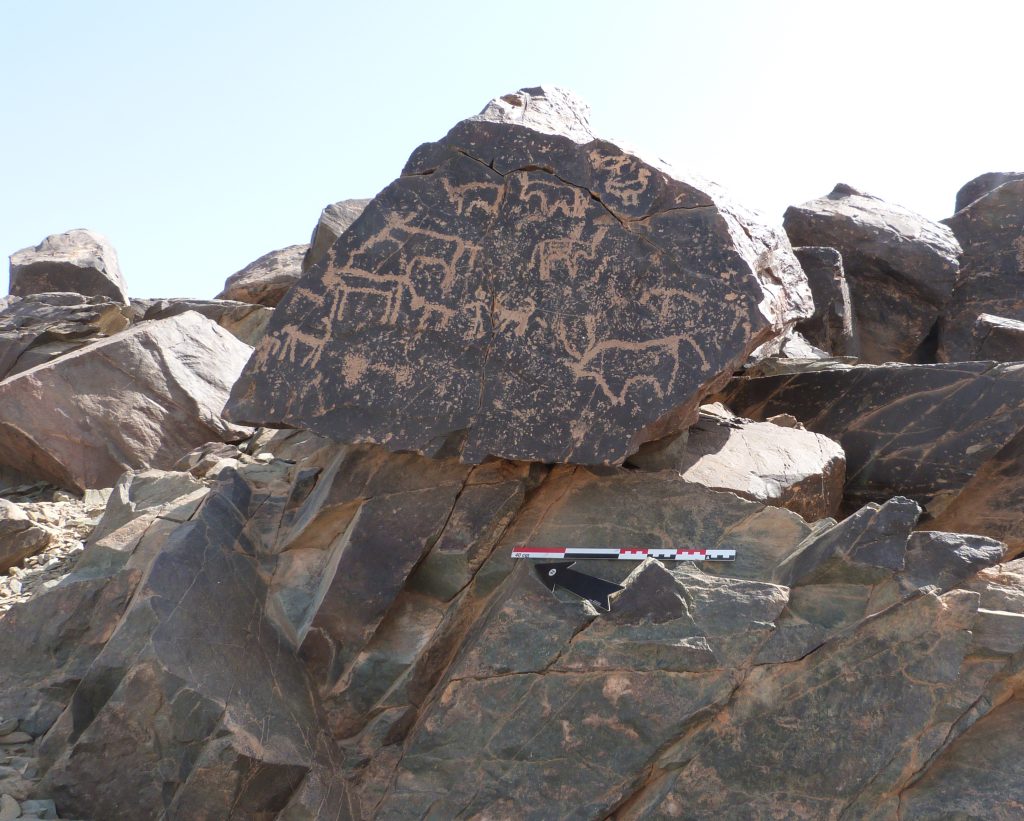
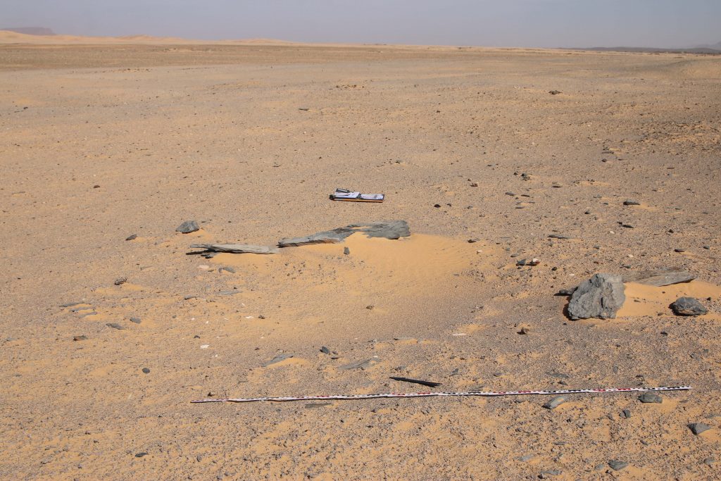
The rock art boulder which made it to the cover of the MittSAG is a prominent rock which shows human-animal interaction and is likely to be interpreted as a ‘pastoral scene’ (see Polkowski 2021). It was already documented by Vila in the 1970s (Vila 1976, 86, fig. 37.3). In various lines, with different styles and shapes of horns, not only cattle, but also birds (probably geese) as well as a goat, a possible calf (or another goat?) and a dog are depicted. Such scenes find plenty of parallels, especially in the Third and Fourth Cataract regions, for which I give the details in the article. It is reasonable to assume that this panel depicts the daily life of pastoralists. All in all, the important role that livestock, particularly cattle, played for people in the Kosha region – during the Bronze Age, but also later – is very clear at site 3-P-5.
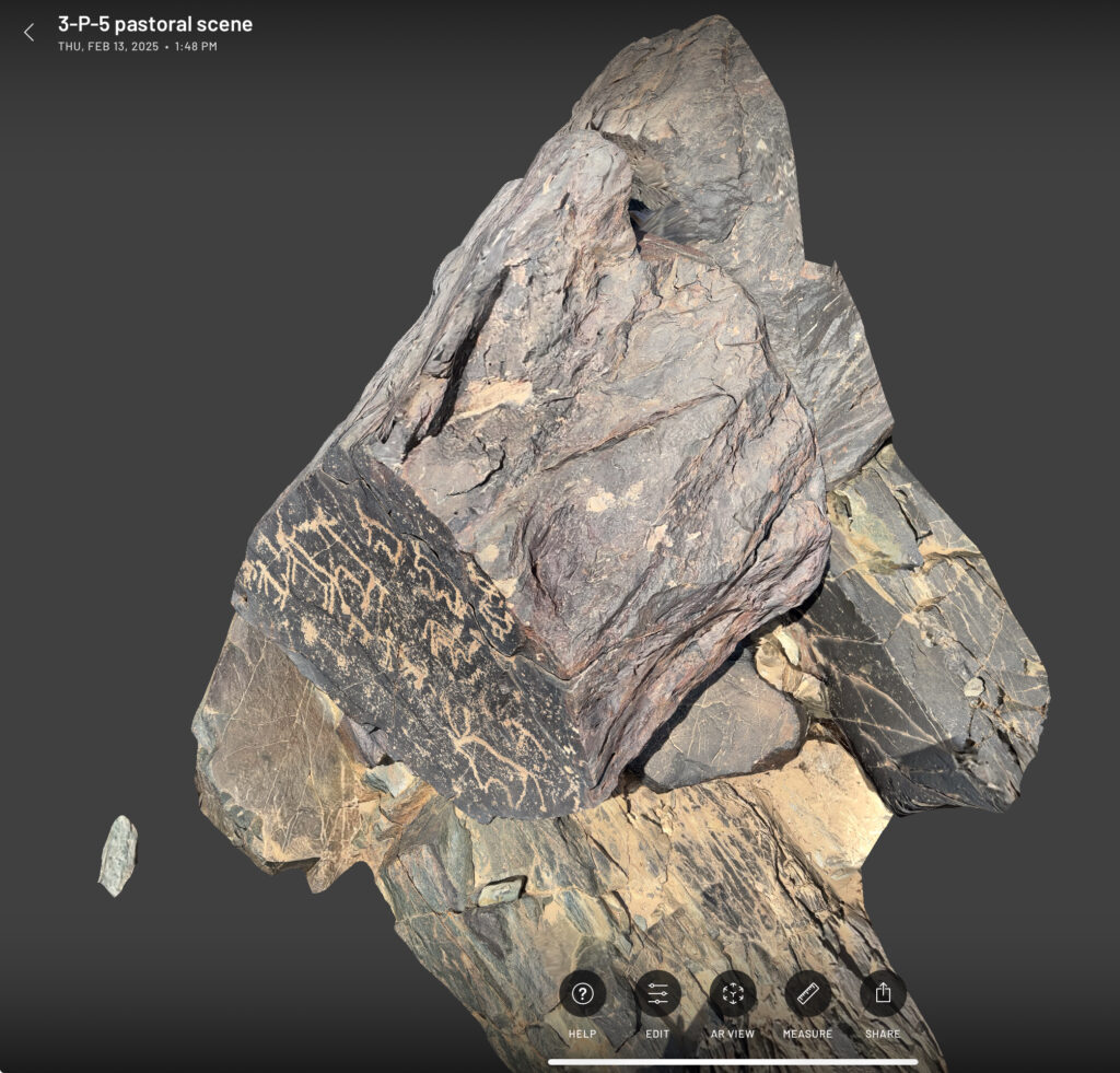
In February 2025, I was very fortunate to be back in the Attab-Ferka region and had the chance to revisit the intriguing site 3-P-5. The aim was to test new ways of documentation of the rock art – introducing 3D scanning with the ultrafast, highly accurate mobile app Scaniverse – a tool, we have been using in Egypt and for our ceramics here in Munich in the past two years. 3D modelling in rock art research in general has made great progress worldwide in recent years – from standard image-based techniques to more sophisticated methods such as terrestrial 3D laser scanners. Given the situation in Sudan, where war is still raging, my focus was on testing the quality of an ultra-fast scanning technique.
The results of documenting rock art with Scaniverse were simply amazing – the app makes it possible to capture not only details, but above all the complete shape and position of the boulders. Larger areas were quickly captured with the iPad, smaller boulders and details are well suited to the smaller iPhones.
Here is a screenshot of the 3D scan of the panel that was first published by Vila in the 1970s, relocated by us in 2020, re-photographed and published in 2024, also becoming a cover star (see above), and now 3D scanned in 2025. The high-resolution scan allows extreme zooming in for details and you can measure every tiny detail.
This example shows very nicely the progress in the documentation of rock art in recent years and makes me very positive about the possibilities of tackling new relevant questions on this fascinating research topic in the near future.
References
Budka, J. 2024. Cattle motifs in Nubian rock art of the Bronze Age– a preliminary update from Kosha, Mograkka and Ferka, MittSAG – Der Antike Sudan 35, 9‒19.
Polkowski, P. L. 2021. “Cattle in the Nile Fourth Cataract rock art: the site of El-Gamamiya 67 as an example.” In Bayuda and its neighbours, ed. by A. Obłuski, H. Paner and M. Masojć, 71-91. Turnhout: Brepols.
Vila, A. 1976. La prospection archéologique de la Vallée du Nil, au Sud de la Cataracte de Dal (Nubie Soudanaise).Fascicule 4:District de Mograkka (Est et Ouest), District de Kosha (Est et Ouest). Paris: Centre National de la Recherche Scientifique.
The aim of this paper was to present the preliminary excavation results of this large Kerma cemetery on the outskirts of Sai. Based on our excavation results from 2022, we know that it was continuously used from Middle Kerma to Classic Kerma times and has close parallels to cemeteries in Batn el-Haggar (especially at Ukma). Our excavations allow a better understanding of rural Kerman funerary practices and the types of imported objects that are present or missing within these communities (such as scarabs, pottery vessels), demonstrating local prosperity and the superregional interconnectedness of these groups.
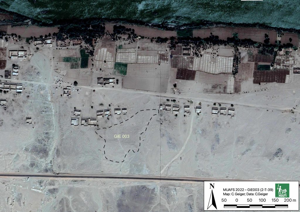
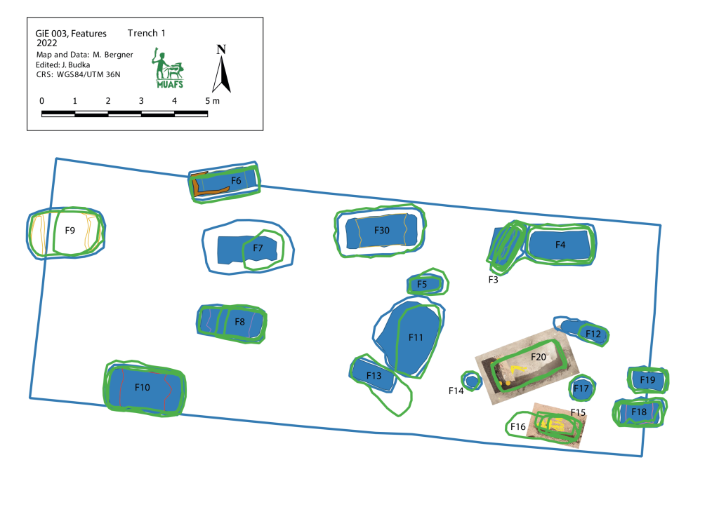
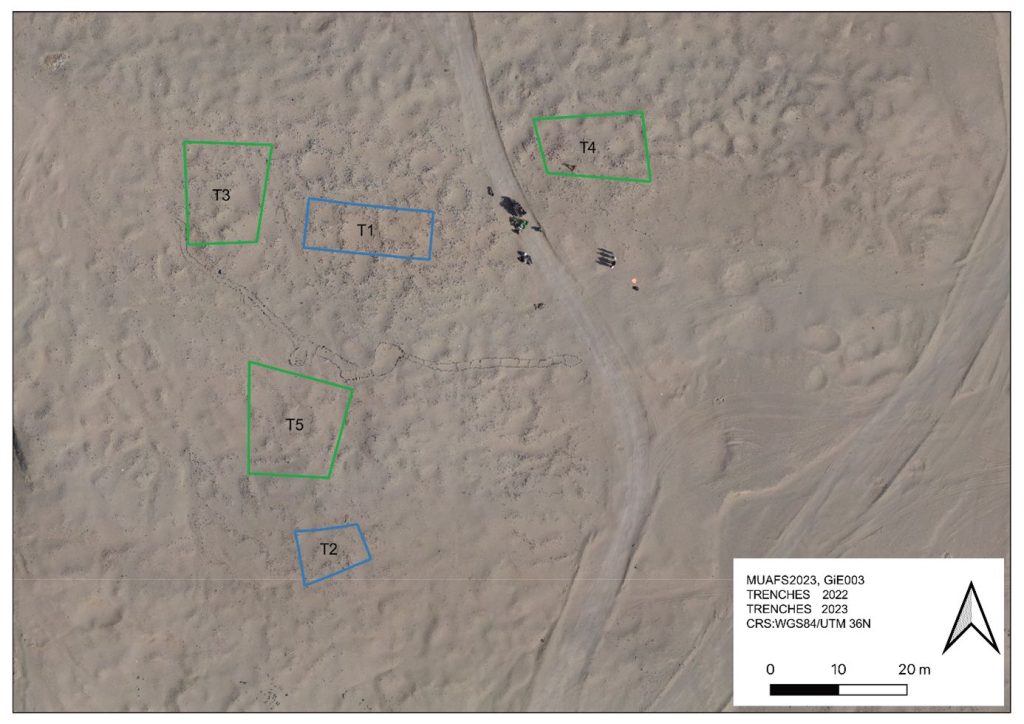
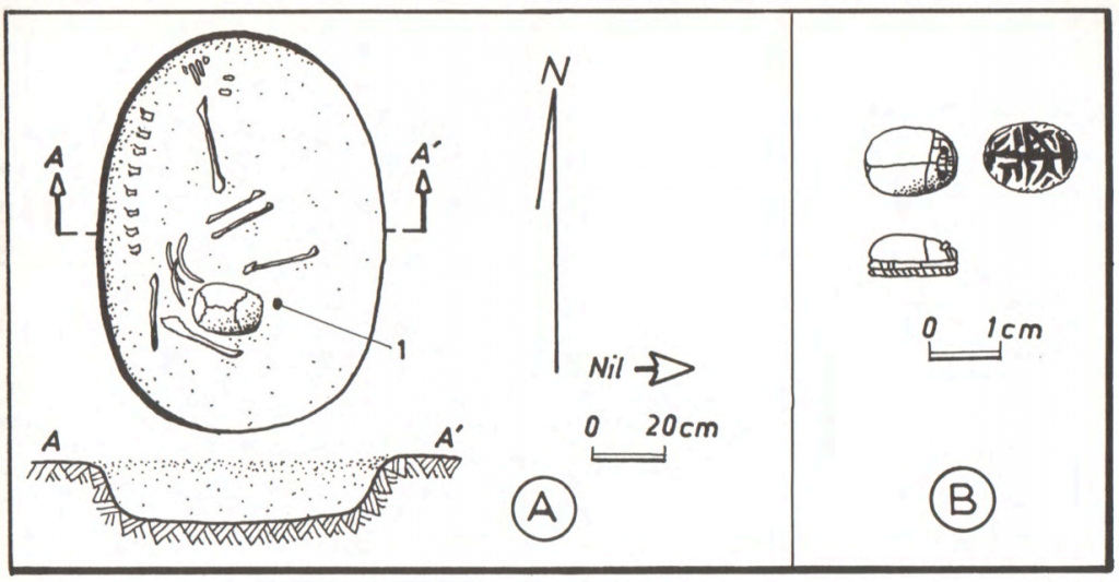
The Kerma cemetery, which Vila documented as 2-T-39, was labelled GiE 003 by the MUAFS project. It comprises an estimated 150 tombs in an area of c. 200 x 100m. The actual extent of the cemetery requires further investigation; in the northern part, the site partially overlaps with the Medieval habitation 2-T-43.
Estimated outline of cemetery GiE 003 (Map: C. Geiger, courtesy of the DiverseNile project).
In March 2022, two trenches were opened in GiE 003 and are discussed in the EVO paper. Both trenches had eroded circular tumuli structures on their surfaces, which were covered with pottery sherds and human bones, clearly indicating ancient looting. Despite the age of the looting, some of the Kerma burials unearthed were well preserved and could be dated through the finds. The finds include fly pendants, a scarab with the name of a Hyksos king, a dagger, remains of funerary beds and plenty of beads as well as pottery.
A total of 27 pits were excavated in 2022. Through stratigraphic and pottery analysis it is also possible to make suggestions on the spatial and chronological development of the site. The EVO article is a preliminary assessment based on fieldwork results from 2022, including my detailed study of all the ceramics, but excluding bioarchaeological studies of human and animal bones, as well as the botanical remains.
The most important result of the 2022 excavation is the dating of the southern trench, Trench 2, to the Middle Kerma Period (c. 2000-1750 BCE) and of the northern trench, Trench 1, to the Classic Kerma Period (c. 1750-1500 BCE). This is especially significant, given that there were no notable differences in the surface structures.
In the EVO article, I proposed a possible relation of the Kerma community using GiE 003 to gold exploitation. First, in the MUAFS concession area, gold-rich quartz-veins have been found in Attab, Ginis, and Kosha, and some archaeological sites point to gold exploitation throughout the centuries, starting well before the Egyptian New Kingdom. Moreover, recent surveys in the Eastern Desert suggest that both control of gold mines and trade relationships with desert nomads played a major role in Kerman access to gold before Egyptian colonisation in the New Kingdom (see Cooper 2021). The affiliation of some of the pottery from GiE 003 with the Pan-Grave horizon seemed to illustrate in 2022 connections to nomadic people, possibly in relation to gold mining. This thesis could now be partly confirmed in 2023: in Trench 5 several Pan-Grave style burials were found (see my short summary of the 2023 season).
Here, I would like to follow Claudia Näser and her appeal for an “archaeology of interaction” (Näser 2012) – during the Kerma period, there were a number of Pan-Grave people present in the Nile Valley and for sure also in the Attab and Ginis area. They were community members (at least seasonally) interacting in various ways with other members – and our focus should be on understanding these interactions and reconstructing them as best we can. This is one of the core interests of the DiverseNile project and will keep us busy in the next years.
Our work in GiE 003 in the 2023 season resulted in many important new insights, supporting and strengthening ideas raised in the EVO article based on the 2022 season.
Coming back to cemetery GiE 003: one of the results of our excavation work is clearly that funerary practices reflecting social practices in the periphery of the Kerma kingdom must be considered in a more complex light than previously thought. Cultural diversity in the Middle Nile is well traceable during the Middle and Classic Kerma age in terms of architecture, location, burial types and grave goods. However, this requires further material assistance, with a focus on the social impact of cultural contact and the emerging patterns of globalisation during the Kerma kingdom’s heyday. The proximity of Kerma cemeteries (and thus also of possible settlements), especially also of dome grave assemblages well attested in the Attab to Ferka region, to potential gold working sites is clearly an interesting research question to be investigated in the future.
All in all, it seems likely that there was no single Kerman cultural input to interactions with the Hyksos, Egyptians and nomadic people like the Pan-Grave horizon. Rather, we must consider various hierarchical local responses determined by different communities’ ability to consume, shaping what can be called marginal communities in the Kerma state (see also Walsh 2022).
To concluse, the rich finds in GiE 003 enable us to compare this newly excavated Kerma cemetery to the well-known cemeteries of Ukma and Akasha further north. There are very close parallels, as well as notable differences and what appears to be local variations (for details see Budka 2022). This opens new avenues for future research on Kerma communities outside of the Third Cataract region, shifting the focus away from cultural and chronological classification and toward aspects of the social relationships among Middle Nile groups (and their neighbours).
References:
Budka 2022 = J. Budka, Investigating Nubian funerary practices of marginal communities: new evidence from a Kerma cemetery at Ginis, Egitto e Vicino Oriente 45, 2022, 37-62.
Cooper 2021 = J. Cooper, Between the Nile and the Red Sea: Medjay desert polities in the third to first millennium BCE. Old World: Journal of Ancient Africa and Eurasia 1 (1), 2021, 1-22.
Näser 2012 = C. Näser, Nomads at the Nile: towards an archaeology of interaction, in: H. Barnard and K. Duistermaat (eds), The history of the peoples of the Eastern Desert, Los Angeles: University of California 2012, 80-89.
Walsh 2022 = C. Walsh, Marginal Communities and Cooperative Strategies in the Kerma Pastoral State. Journal of Ancient Near Eastern History, 9/2, 2022, 195-220.
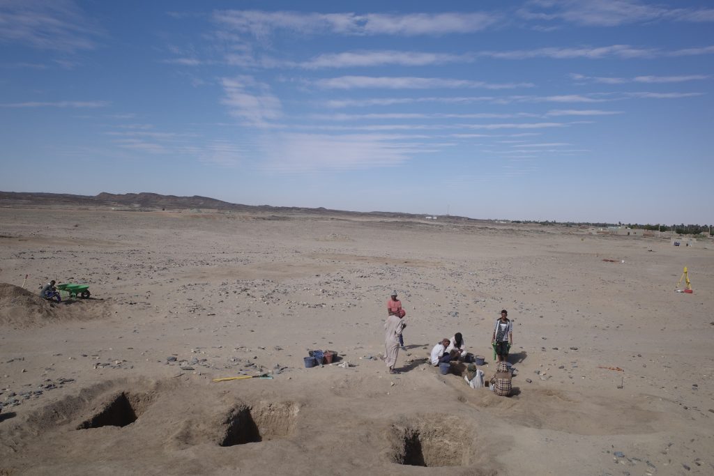
The excavation season of the fourth MUAFS campaign lasted from January 23 to March 18 2023, and focused on aims of the ERC Project DiverseNile, investigating Bronze Age sites (Kerma and New Kingdom) and cultural diversity in the region. The team was supported by Huda Magzoub Elbashir as Antiquities Inspector from NCAM. Our major activities in the 2023 season are summarised in the following.
Excavations
We focused on Bronze Age sites in the area of Ginis and Attab. Our selection included two settlement sites, AtW 001 and site 2-S-54, and one cemetery, GiE 003. Work was carried out with the support of a team of 12 local workmen from Ernietta, Ginis and Attab.
AtW 001
In 2023, the complete mound of this site in Attab West was excavated (Trench 2). Substantial layers of mud brick collapse were found as well as several phases of poorly preserved mud brick structures.
Location of Trench 2, situation before the excavation in 2023.
The domestic character of the site is also obvious from many ashy spots, rubbish deposits including much animal bones and charcoal as well as loads of broken pottery and a surprisingly large number of intact and almost intact vessels. In addition, several round and oval-shaped storage pits were documented, some of them with traces of firing/ash and possibly also connected with heating/cooking.
Most importantly, the same ashy layer on the alluvial surface like in 2022 was reached in the northern part of Trench 2. It is now clear that apart from a slight natural slope, most of the mound-like appearance of site AtW 001 was composed of settlement debris and especially mud brick debris in several layers, all dating to the 18th Dynasty.
Vila site 2-S-54
Structure 1 at site 2-S-54 is a domestic building measuring 6.5 x 3.5m on the interior and preserved to more than 80cm in height, datable to the 18th Dynasty. We cleaned it from windblown sand and exposed a substantial layer of mud brick debris as well as internal mud brick structures. The feature seems to have been divided in at least three parts, presumably with an open courtyard in the centre. It is still unclear where the main entrance of the structure was originally located (one side entrance seems to have been on the east side in the centre, leading into the open courtyard). Ceramics and collapsed mud bricks were also found on the slope towards the south and this area still needs to be fully cleaned and documented.
Structure 1 at 2-S-54 shows an intriguing mix of stone and mud bricks as building material.
GiE 003
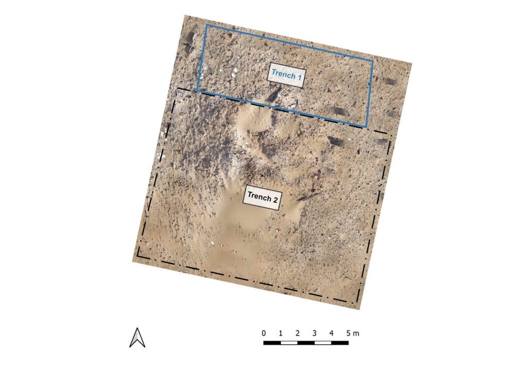
We excavated three new trenches (Trenches 3, 4 and 5) to check the extension of this Kerma cemetery, the distribution of burial types and chronological aspects.
Location of the trenches excavated in GiE 003 in 2023 (including the 2022 trenches in blue).
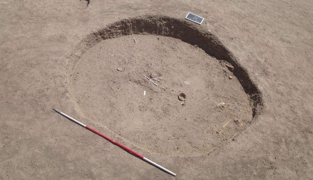
The oldest material was exposed in Trench 5, just north of the Middle Kerma burials in Trench 2. One Middle Kerma circular pit (Feature 53) and a total of four pits associated with Pan-grave style material were discovered.
The largest pit, Feature 50, contained the remains of a wooden bed frame, the remains of a human contracted burial, several goat offerings and a considerable number of intact pottery vessels, comprising Black-topped fine wares as well as incised and impressed decorated vessels.
Feature 50, the Pan-Grave burial pit (second situation with goat offerings and complete pots).
Trench 3 yielded a total of 14, Trench 4 ten new Classic Kerma burial pits, closely resembling our results from 2022 in Trench 1. These burials are rectangular east-west oriented burial pits with rounded corners, vertical walls, and two depressions in the east and west for the funerary bed of which wooden remains were found in some of the features. Two niche burials in Trench 4 also seem to date to the Classic Kerma time.
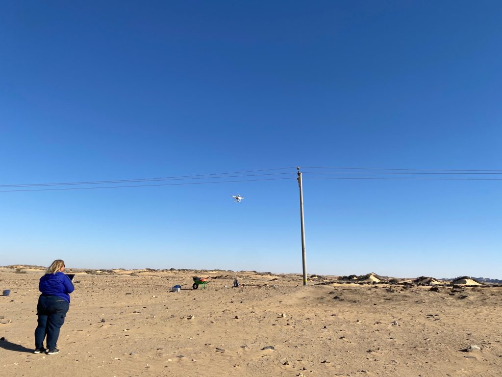
Drone Aerial Photography
Kate Rose was busy conducting Drone aerial photography (DAP) at the excavated sites and on a larger scale at Attab West, Attab East, Ginis East and Ferka East. Many precise measurements were taken with our new Trimble Catalyst GNSS Antenna and extensive mapping of drystone walls in Attab and Ginis West was carried out as well.
Kate documenting the final state of AtW 001 with our drone.
Find documentation
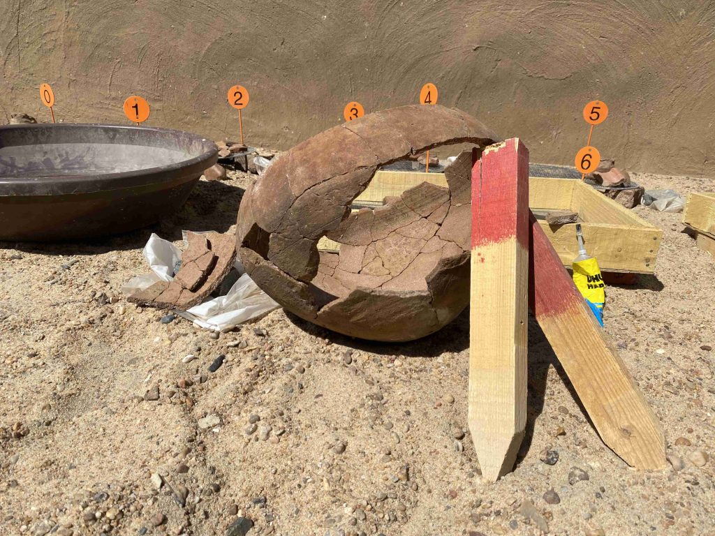
We used a total of 566 find bag numbers in the 2023 spring season. 229 finds were registered, photographed and recorded in detail in the Filemaker Database.
One of the highlights of the ceramic processing 2023: a complete cooking pot from AtW 001 reconstructed from many fragments.
Simultaneously to the excavations, I carried out the recording of the pottery. The numerous settlement material from AtW 001, accounting to more than 10.000 sherds, was very time consuming to process, especially since a large number of pottery vessels could be reconstructed from fragments to complete vessels like an amazing hybrid cooking pot. A total of 43 vessels was documented by drawing in 2023.
The 2023 season survey
Two Vila sites in Attab West and one in Kosha East were newly identified and documented as well as seven new MUAFS site in Attab East, Attab West and Kosha East. A number of these sites is difficult to date and might be sub-recent.
In sum, our 2023 season was very successful, achieving all planned work tasks despite of the looting events and the destruction of site 2-S-54. Especially cemetery GiE 003 with its mixed material culture of Middle Kerma, Pan-Grave and Classic Kerma illustrates cultural encounters between various Nubian groups in the region. The living aspect of these cultural encounters seems to be traceable at sites like 2-S-54 where both Egyptian and Nubian ceramics were found, rectangular and circular buildings appear side by side and mud bricks were used jointly with dry-stone architecture.
Plenty of post-excavation work is now waiting for us and updates will follow soon.
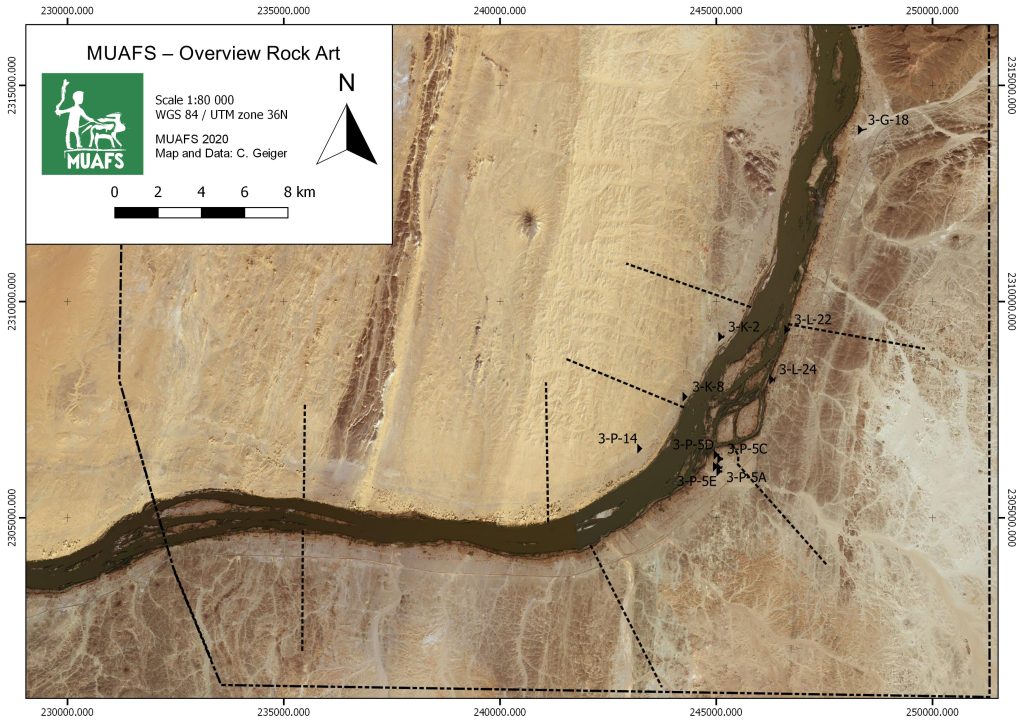
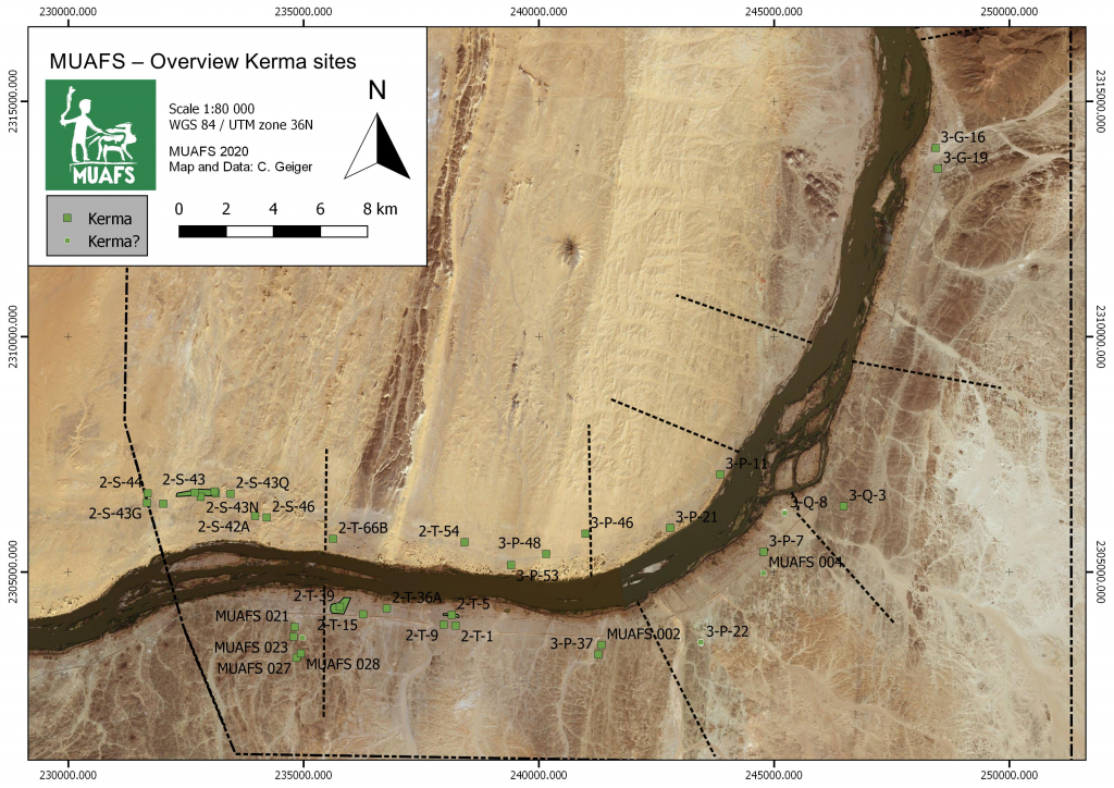
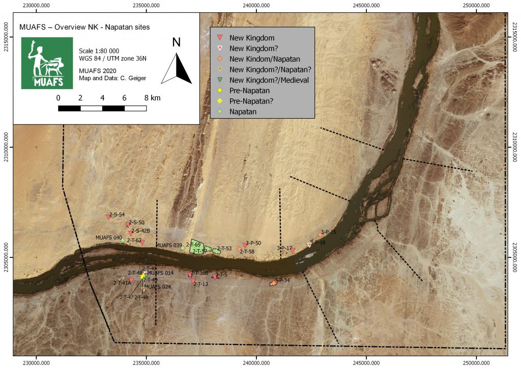
Rock art in Sudan has become one of my favourite topics ever since I worked in the Fourth Cataract region in the 2000s. Within the MUAFS concession between Attab and Ferka, there are not many sites with rock drawings. Unsurprisingly, rock art is restricted to certain areas with fitting geology and large boulders – in our concession these are the districts of Ferka, Mograkka and Kosha (Fig. 1). Close to Mograkka, one particularly handsome engraving was chosen as the basis for the MUAFS logo.
Fig. 1: Map with rock art sites located in the MUAFS concession (status 2020).
Some of these sites are located in close proximity to Kerma funerary sites. This holds especially true for 3-P-14 (Kosha West), 3-G-18 (Ferka East) and 3-P-5 (Kosha East).
3-G-18 is located on rocky outcrops within the large plain of Ferka and directly adjacent to the Kerma cemetery 3-G-16 (Fig. 2). Kerma cemetery 3-G-19 is also not far away. These sites are of particular interest because they are the northernmost Kerma sites in our concession.
Fig. 2: Map showing the close relations between Kerma cemetery 3-G-16 and rock art site 3-G-18.
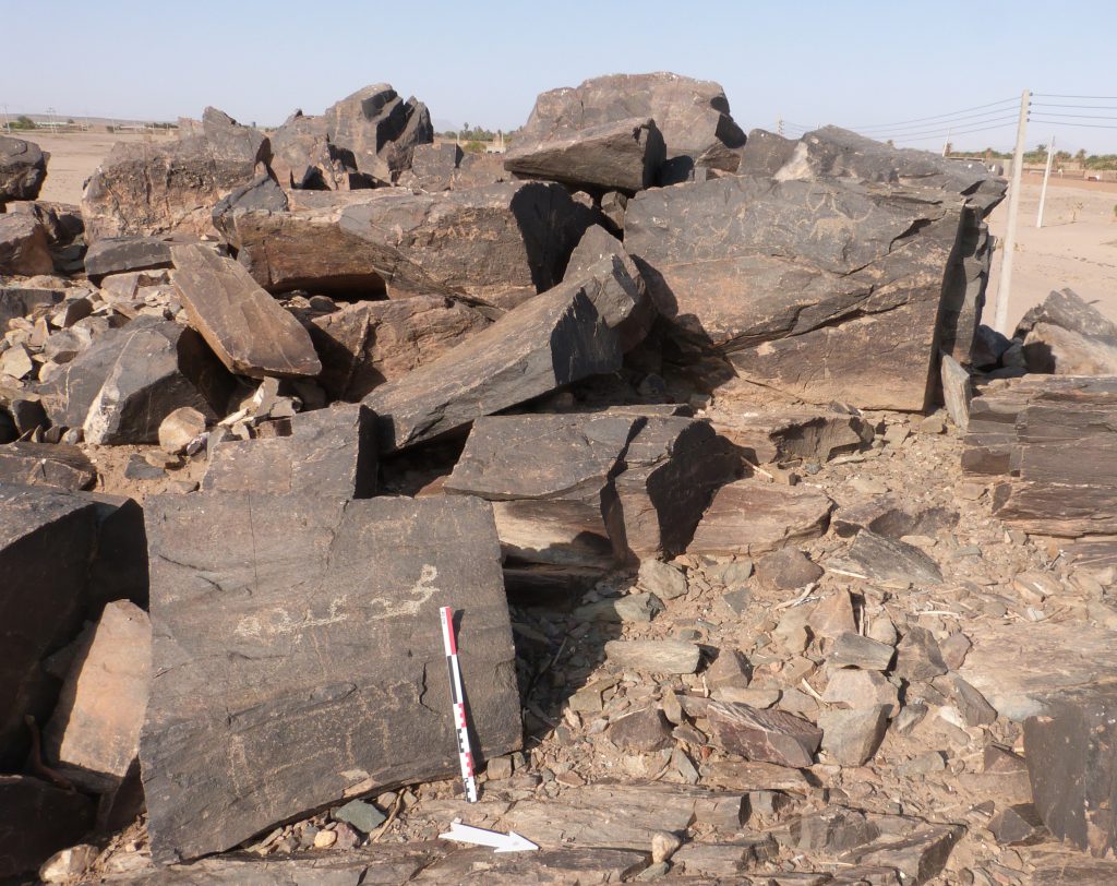
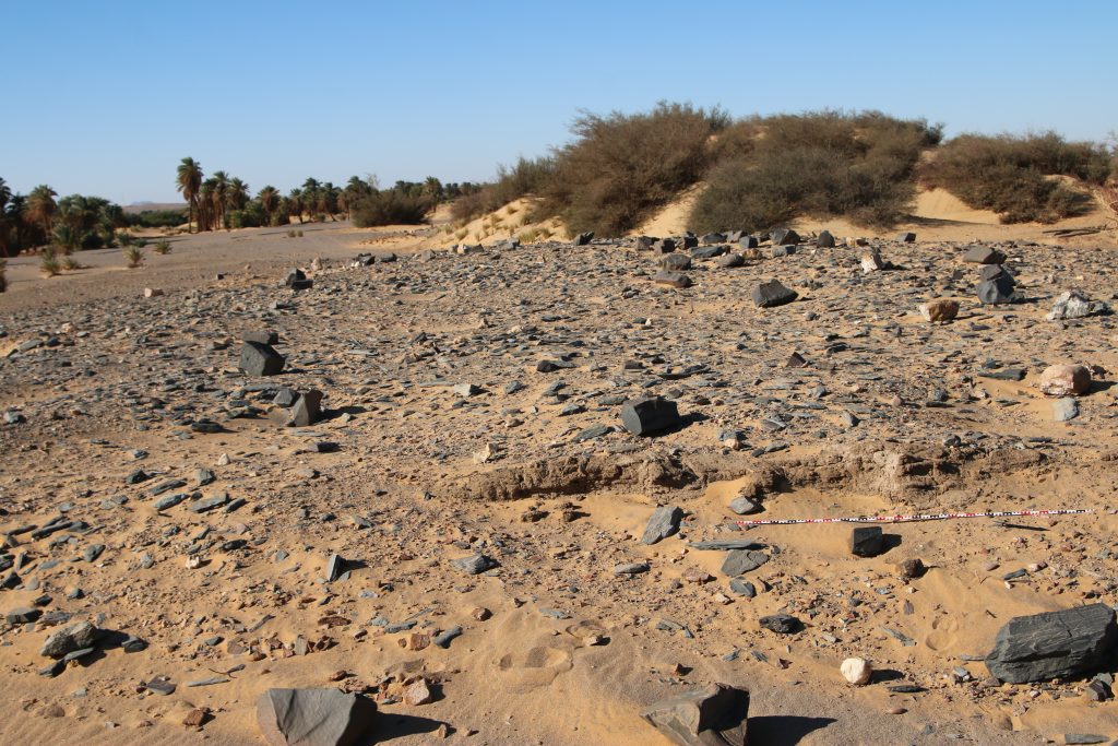
The largest rock art site is located at the border between Mograkka and Kosha East, site 3-P-5, with more than 400 individual rock art pictures (Vila 1976, 79‒87). The motifs comprise mostly cattle, antelopes, some human depictions, birds, dogs and other animals (Figs. 3-4).
Fig. 3: Example of rock engravings in 3-P-5. Cattle is the most frequent motif.Fig. 4: Example of rock engravings in 3-P-5. This boulder shows cattle, but also birds, humans and possibly a dog.
While Vila left the dating as unclear, most of the rock art pictures at 3-P-5 seem to belong to the Kerma period (Budka 2020). Similar to 3-G-18 in Ferka, there are Kerma sites in the close proximity to 3-P-5 which support this dating.
In all phases of the Kerma culture, the dominant motif of rock art is cattle. Of course this reflects the importance of cattle herding to Kerma people – some aspects of which were recently addressed by Jérôme Dubosson at one of our DiverseNile Seminar Series 2022. In the words by Louis Chaix: “Cattle are a key constituent element of the civilization of Kerma. They played a major role in the diet of the population and as a source of secondary products such as milk, hides, and raw materials for making tools. They also contributed to agriculture as traction animals.” (Chaix 2017). Within the DiverseNile project, we aim to address the local role of cattle for the Kerma people by means of a multidisciplinary approach, combining landscape archaeology with bioarchaeology and of course analysing all kinds of archaeological findings like animal bones, animal figurines and engraved figures of cattle in rock art.
Coming back to the question of rock art, the spatial proximity of rock art panels depicting cattle and Kerma funerary sites was already noted by Cornelia Kleinitz in the Fourth Cataract region (Kleinitz 2007). As tempting as it is to link these rock drawings with Kerma funerary cult, at the Fourth Cataract and also in the MUAFS concession, a precise dating of cattle depictions in rock art often remains impossible.
Nevertheless, we will soon be back in the field in Sudan – one of the goals for the 2023 season is to expand the documentation of rock art in our concession, with a special focus on possible Kerma sites. Contextualising rock art sites clearly has much potential for a closer understanding of their date and function.
References
Budka, Julia 2020. Kerma presence at Ginis East: the 2020 season of the Munich University Attab to Ferka survey project. Sudan & Nubia 24, 57-71.
Chaix, Louis 2017. Cattle: a major component of the Kerma culture (Sudan). Edited by Umberto Albarella, Mauro Rizzetto, Hannah Russ, Kim Vickers, and Sarah Viner-Daniels. Oxford Handbooks Online 2017 (April), 15 p.; 4 figs. DOI: 10.1093/oxfordhb/9780199686476.013.2
Kleinitz, Cornelia 2007. Rock art and archaeology: the Hadiab survey. Sudan & Nubia 11, 34-42
Vila, André 1976. La prospection archéologique de la Vallée du Nil, au Sud de la Cataracte de Dal (Nubie Soudanaise).Fascicule 4: District de Mograkka (Est et Ouest), District de Kosha (Est et Ouest). Paris.
Studying Kerma remains in the MUAFS concession area will provide fresh and urgently needed input for manifold, still open questions about a region far north of the Kerma capital, as our PI Julia Budka stated lately in her article about the Kerma presence in Ginis East (Budka 2020).
Today, I would like to give a short outlook over the settlements of the Kerma horizon in the Attab to Ferka region and exemplarily introducing you to an intriguing site, which seems to hold the potential for further thought (for Kerma tombs in Attab to Ferka see the blog entry of my colleague Rennan Lemos with his presentation of a fascinating Kerma burial).
Currently, 30 settlements classified as Kerma are included in our database – whereby Egyptian New Kingdom presence at some of them and vice versa clearly illustrates the need to move away from the previous used interpretation of sites as rigid ‘Egyptian and ‘Nubian’ cultural units, addressing them as more closer interconnected cultures in this region (Budka 2020: 63).
Concerning their location, the settlements with Kerma presence are consistently distributed between both river banks with a certain dominance (18) on the right bank. Kerma sites on the left bank (12) were often situated in an impressive distance from the modern Nile, thus following the ancient course of the river. Besides a striking number of Kerma remains in the districts Attab and Ginis, Kerma sites can also be traced much further north (see Fig. 1).
Figure 1: Kerma sites in the region from Attab to Ferka (status 2020). Budka 2020: fig. 13 (modified).
These observations will not only shed further light on Sai during the Kerma period and its periphery, or the northern borders of the Kerma kingdom. Particularly important will be the insight how people lived there in the period of the New Kingdom occupation of Nubia – how the diverse social and cultural groups interacted with each other away from the major urban centres, collectively shaping, exploiting and making the landscape their home (Budka 2020: 63, Budka 2019: 24).
In a contact space like Attab to Ferka, it is the physical manifestations of the living that can shed light on how a cultural exchange could have happened, not only through the adoption or modification of ‘Egyptian’ patterns by the Nubians, but clearly vice versa – visible in the choice of design or used building material. Concerning the latter, with the fascinating site we will have a closer look now, I will focus today on dry-stone as building technique – a method Liszka states that “appears to have been passed down through generations of Nubians for many millennia” (Liszka 2017: 41).
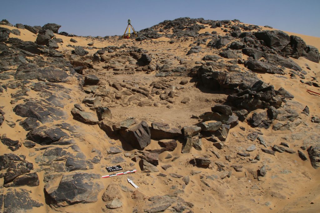
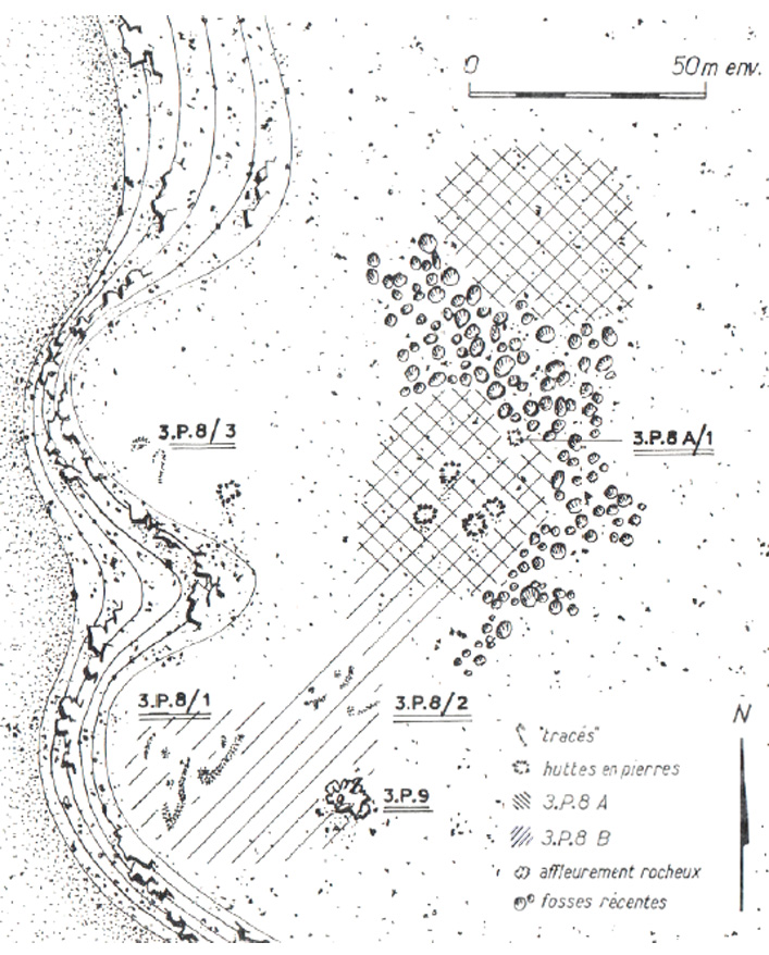
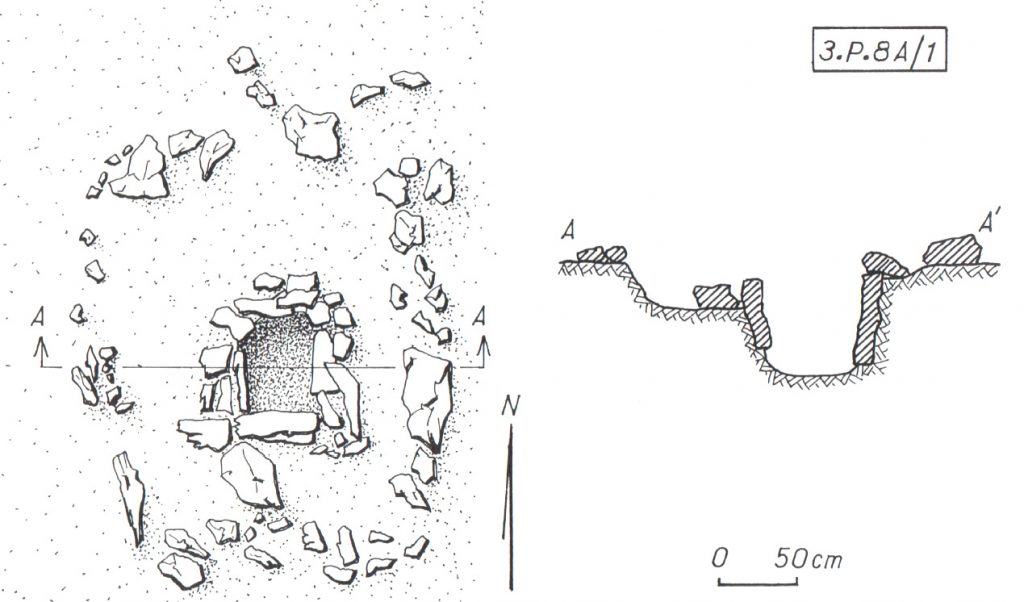
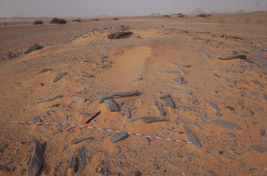
Besides the material the second characteristic of this site, detected by Vila and his team at Mindiq and numbered as NF-36-M/3-P-8 is its location further in the north of the MUAFS concession (Vila 1976: 90–96). More precisely the archaeological remains were found in the north-eastern part of Kosha East, situated in an impressive distance of 750 m to the modern Nile on the first hills rising 10 to 12m above the Kosha plain. The site occupied an overall surface of 200 x 60m (NE-SW), with intermediate sterile zones.Within this area, the areal NF-36-M/3-P-8A/B is from special interest (Fig. 2), being categorised by Vila as habitation site – a term he specifically used for remains of organised structures, perhaps being once a permanent settlement.
Whereas Vila still proposed a Neolithic or Nubien Ancien/Moyen context of the site, his attribution could be revised by our PI during our last campaign, giving, besides the Neolithic, a presumptive Old or Middle Kerma date, based on a large number of Kerma pottery.
Looking closer at Vila’s description of the character and the nature of the site, the division in 3-P-8A and 3-P-8B is explained by the existence of stone structures together with sherds and stone tools in part 3-P-8A at the centre and in the northern part of the site, whereas 3-P-8B consisted of a massive amount of stone tools scattered all over the site, with a certain concentration in the southern part, where no sherds were found.
Figure 2: Mindiq, General sketch plan of site NF-36-M/3-P-8A/B (Kosha E). Vila 1976: fig. 41 (modified).
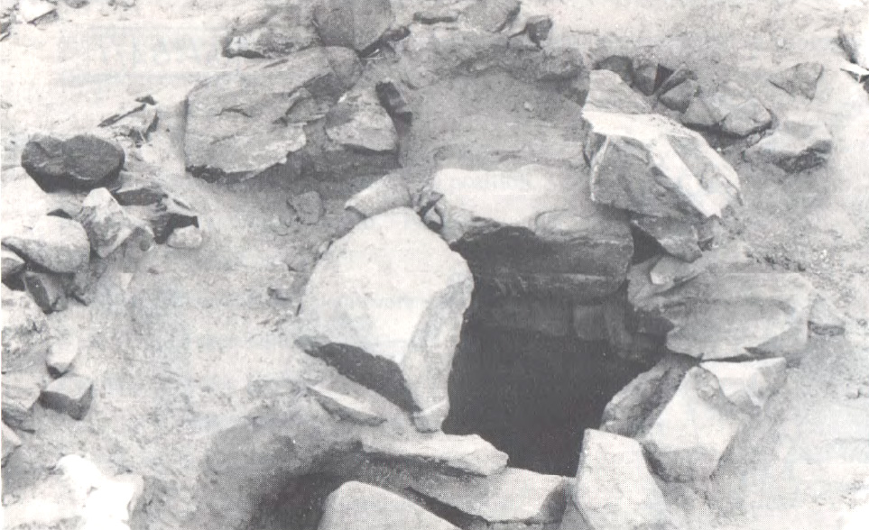
Concerning the questions of used material and building techniques the design of the stone remains in 3-P-8A are highly interesting – for a tentative interpretation of the site’s purpose also the nature of 3-P-8B can add some hints. In 3-P-8A Vila noted the remains of five dry stone huts – and in close proximity to them (originally connected?) – a feature from special interest (3-P-8A/1) (only) for which he gave a more detailed sketch plan and description: Its visible remains consisted of a quite circular structure made of stone blocks (possibly continuing with similar adjoining structures further north) with a diameter of approx. 4m. Within this stone structure the most interesting detail is a square stone-lined bin measuring approx. 60 cm x 60cm, with a depth of around 50/60cm, whose vertical walls were reinforced with raised slabs (Figs. 3a, b).
Figure 3a: Sketch plan and section of circular structure with stone-lined bin (NF-36-M/3-P-8A/1). (Vila 1976: fig. 42).Figure 3b: Detail of stone-lined bin in NF-36-M/3-P-8A/1, view towards S. (Vila 1976: fig. 44.1).
When visiting the place in the 1970ies, Vila and his team noted a heavily disturbed area in the northern part of the site, dividing 3-P-8A in two zones (Fig. 2), and consisting of pits of modern stone extractions. A similar picture emerged during our visit in the last campaign, when we found the site badly damaged by modern gold mining. These endangering activities not only clearly illustrate the urgent need of our research in the MUAFS concession, but also the richness of resources of this region, especially in this area, still being extracted today.
Thus, together with the abundance of stone tools indicated by Vila in 3-P-8A/B – further attested by the numerous quartz flakes we found on site – may point to an original purpose of the site associated with gold processing activities. In this context, one may wonder what role the above mentioned stone-lined bin might have played and if the architectural nature of the site 3-P-8/A with its dry-stone constructions could strengthen this assumption? Looking outside the box – thus beyond the MUAFS research area to other comparable frontier and contact spaces of similar time periods within Nubia may help to gain more thought-provoking hints.
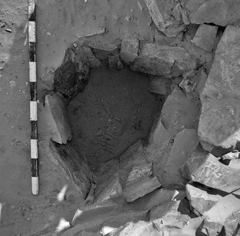
Here I will just refer to the evidence in the Batn el-Hagar, recently published by Edwards who introduced the occurrence of a fascinating category of Pharaonic sites, that clearly outnumbered other types of settlements in this region. Besides their number, their peculiarity consists especially of their dry-stone architecture and their often curvilinear layout – representing as Edwards stated “a still unfamiliar form of an ‘Egyptian’ presence” in Nubia (Edwards 2020: 378). These sites were apparently linked to gold mining activities within the region, which is why Edwards refers to them as ‘workshop sites’. Mostly situated in larger distances to the Nile their architecture consists of a number or dry-stone walls forming complexes of subcircular or curvilinear rooms. The different equipment found in these rooms points to different working units and working steps, as illustrated by large granite mortars and grinding installations of diverse types – but it is especially indicated by numerous stone-lined bins or tanks (Fig. 4) comparable to “our” example from Mindiq. Some of the latter seemed to be originally associated withworking processes using water and still contained accumulations of fine water-laid crushed gold bearing quartz (Edwards 2020: 404).
Figure 4: Example of a stone-lined bin (diam: 55 cm, depth: 45 cm, workshop site 11-Q-61, Saras E). Edwards 2020: fig. 3.3.31.
Concerning the rather unusual ‘Egyptian’ architectural appearance of those workshop sites, Edwards suggested a possible more complex history of Egyptian gold mining in this region – and a very plausible stronger role of Nubians in this context. His assumption was not only based on often found Nubian or Kerma style pottery within these workshops (f. ex. Duweishat area, workshop 16-O-12, Attiri – Sorki, with even a predominance of Nubian style ceramics, Edwards 2020: 226–234), but also on the existence of at least one similar site clearly dating in the Middle Kerma period (Duweishat area, workshop 16-S-16, also addressed as ‘Kerma/C-Group’ workshop site). The layout, finds and crushed quartz debris of his clearly Nubian site hold striking similarities to those qualified as Pharaonic workshop sites in this region (Edwards 2020: 406–407).
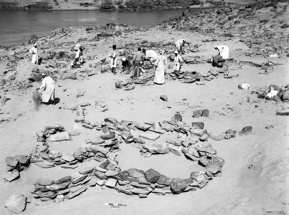
Figure 5: ‘Kerma/C-Group’ workshop site (16-S-16, Duweishat), 1967. Several large grindstones are visible at floor level of the nearest structure. Edwards 2020: Fig. 7.32.
Returning to our site in Kosha E, 3-P-8A/B, it would be tempting not only to assume a similar functional purpose, but – indicated by the today still visible remains – an original possibly related architectural layout. With clearly still needed further research in the coming years, this site with its presumed Old and Middle Kerma context already is from special interest due to its possible earlier date than the aforementioned site 16-S-16 in the Duweishat region. Thus site 3-P-8A/B, holds not only important hints about the gold-working activities in the Attab to Ferka area but also may help to shed further light on early Nubian gold exploitation.
Not least this early site has the potential to deeper explore the still pending ‘chicken or the egg-problem’ – so the question (is it) ‘Egyptian or Nubian?’ that Liszka chose concisely as title of her important article (Liszka 2017) on the matter of dry-stone architecture in Nubia in ‘Egyptian’ contexts. It is precisely such sites, that not only allow us to find answers concerning the activities of ancient people living there and the reasons for the choice of diverse building techniques, for different materials or locations (f. ex. being possible rather pragmatic choices depending on the better availability of stone or are they rather hinting to an internal cultural variability? Or point they to a rather seasonal occupation resp. are explained by the sites purpose?). But most importantly, architectural remains, such as these dry-stone buildings used by ‘Nubians’ or ‘Egyptians’ can also contribute to reconstruct the dynamics of such an ancient ‘contact space’ as the Attab and Ferka region – does it point, f. ex. to knowledge transfer throughout the times and cultures or to the inclusion of craftsmanship of well-trained people, thus not only resulting in acceptance or appropriation of various cultural influences, but also in possible fusions creating together something new.
In this regard – stay tuned for further insights in the fascinating topic of exploring the settlement-scape and the nature of living in the Attab to Ferka region!
References
Budka, J. 2019 (with contributions by G. D’Ercole, C. Geiger, V. Hinterhuber and M. Scheiblecker). Towards Middle Nile Biographies: the Munich University Attab to Ferka Survey Project 2018/2019, in: Sudan & Nubia 23, 13–26.
Budka, J. 2020. Kerma presence at Ginis East: The 2020 season of the Munich University Attab to Ferka Survey Project, in: Sudan & Nubia 24, 57–71.
Edwards, D.N (ed.). 2020. The Archaeological Survey of Sudanese Nubia, 1963–69. The Pharaonic Sites. Oxford.
Liszka, K. 2017. Egyptian or Nubian? Dry-Stone Architecture at Wadi el-Hudi, Wadi es-Sebua, and the Eastern Desert’, in: Journal of Egyptian Archaeology 103(1), 35–51.
Vila. A. 1976. La prospection archéologique de la vallée du Nil au sud de la Cataracte de Dal. Fascicule 4. District de Mograkka (Est et Ouest). District de Kosha (Est et Ouest).Paris.
Sudan & Nubia 24 is now out and it includes a paper by PI Julia Budka on the Kerma presence at Ginis East (Budka 2020). The paper also presents an updated overview of MUAFS fieldwork, which relates to my work in the DiverseNile Project focusing on Kerma, New Kingdom and early Napatan cemeteries in the region. In the past three seasons, the MUAFS team reidentified hundreds of sites firstly described by Vila, but also identified 40 additional sites so far, including tombs which are of interest to my subproject. In my previous posts, I have focused mainly on the New Kingdom. Here I will present a brief overview of the Kerma presence, as attested by cemetery sites and isolated tombs, in Attab-Ferka (figure 1).
Figure 1: Kerma sites in the region from Attab to Ferka (status 2020). Budka 2020, fig. 13.
I have previously mentioned that, for the New Kingdom, our knowledge is mainly based on evidence from major colonial settlements and cemeteries. There are clear geographical gaps in what we know about the Egyptian colonisation of Nubia in areas such as the Batn el-Hajjar (Edwards 2020) or the MUAFS concession area. A similar situation occurs during the Kerma Period. As Julia Budka pointed out in her recent S&N paper, evidence from Attab-Ferka is extremely relevant “to address the issue of the borders of the Kerma kingdom as well as cultural manifestations of what has been labelled as ‘rural Kerma’” (Budka 2020: 63).
Veronica Hinterhuber’s last post provided an overview of her general database of sites based on information published by Vila. Her work is invaluable for my preliminary assessment of mortuary sites in our concession area. Based on her database, 10 mortuary sites first identified by Vila as dating to the Kerma Period can help us to preliminarily understand the Kerma spread in the region. Recent fieldwork has identified a large degree of destruction and plundering at those sites, which makes it important to revisit previously published and archival data with a fresh mindset to extract valuable information. Comparison with other sites, especially those at the Kerma hinterland and other ‘peripheral’ zones across Nubia, also help us shed light onto blurred spots in our datasets from Attab-Ferka.
Besides the overall plundering, Kerma tombs in the region were tumuli with granite superstructures (usually not preserved) and oval or large rectangular pits containing bone fragments, sherds and very rarely burial goods (e.g., faience beads). Kerma tombs were either larger, aprioristically isolated tombs or part of cemeteries grouping a higher number of burials; e.g., at Ferka East and Kosha East. A few skeletons were found in situ, although plundered. They were all deposited in a flexed position, sometimes on a bed; e.g. at Ferka East. Kerma tombs were reused in the Christian Period. For instance, one wrapped body dating to this period was found inside a Kerma tomb at Kitfogga, Ferka East. Sherds usually include Kerma beakers and goblets. Due to plundering, it is difficult to determine, based on the amount of information currently available, whether these burials were characterised by a simple approach to graves goods or not. Comparison with sites such as Abu Fatima, where Stuart Tyson Smith and Sarah Schrader are currently working, should allow us to gain a better picture of continuity and variation in Kerma contact spaces between, for instance, elites and non-elites or urban and rural communities.
The region from Attab to Ferka was not only a contact space within the Kerma state. It was also an area where the Kerma ‘culture’ interacted with Egyptian patterns. For example, one very interesting burial was excavated by Vila at Shagun Dukki, Ginis East, where c. 10 other tombs were detected (figure 2). It consisted of a shallow, oval pit inside of which a flexed skeleton was found (disturbed). Together with the skeleton, a bone scarab was found in the right hand, a common pattern at Classic Kerma burials at Kerma city (Minor 2012: 144). Most scarabs found at Kerma city bear similarities with scarabs from Second Intermediate Period Egypt and Syria-Palestine and would have been acquired either via trade or reuse of graves in Lower Nubia (Minor 2012: 138-140). It is difficult to read the signs on the base of the scarab from Shagun Dukki. Moreover, bone was a material used to manufacture various items in the Kerma Period, as well as among other Nubian communities, and worked as a Nubian identity marker in the New Kingdom. Were bone scarabs the result of local copying practices? Looking at the evidence from Attab-Ferka holds the potential to shed light on internal contact and variability within the Kerma realm, as well as the local roles of foreign objects in local contexts in this period.
Figure 2: A Kerma burial at Shagun Dukki, Ginis East (Vila 1977: 25).
Gratien has previously pointed out how little we know about the Kerma state outside Kerma city, as well as how the Kerma state related to other ‘Nubian’ communities north and south of the Third Cataract (Gratien 2014: 95; 1978; Bonnet 2014). Evidence from Sai (Gratien 1986) and the Fourth Cataract (Paner 2014; Herbst and Smith 2014; Wlodarska 2014; Emberling et al. 2014) can illuminate further aspects of the spread of Kerma throughout the Middle Nile. The publication of evidence from Lower Nubia is also much expected (see Edwards 2020). Recent scholarship has also been shedding light on alternative, ‘rural’ experiences of the Kerma state outside of Kerma city (Akmenkalns 2018) and comparative, ‘global’ perspectives on specific categories of artefacts across cultural borders provide interesting avenues of inquiry (Walsh 2020). In a few years, the results of the DiverseNile Project will also contribute to our understanding of a more complex and diversified landscape beyond rigid cultural divisions.
References
Akmenkalns, J. 2018. Cultural continuity and change in the wake of ancient Nubian-Egyptian interactions. PhD thesis, University of California Santa Barbara.
Bonnet, C. 2014. Forty years research on Kerma cultures. In The Fourth Cataract and beyond, eds. J. Anderson and D. Welsby, 81-94. Leuven: Peeters.
Budka, J. 2020. Kerma presence at Ginis East: The 2020 season of the Munich University Attab to Ferka Survey Project. Sudan & Nubia 24: 57-71.
Edwards, D. ed. 2020. The Archaeological Survey of Sudanese Nubia, 1963-69. Oxford: Archaeopress.
Emberling, G. et al. 2014. Peripheral vision: Identity at the margins of the early Kingdom of Kush. In The Fourth Cataract and beyond, eds. J. Anderson and D. Welsby, 329-336. Leuven: Peeters.
Gratien, B 1986. Saï I. La Nécropole Kerma. Paris: CNRS.
Gratien, B. 1978. Les cultures Kerma: essai de classification. Villeneuve-d’Ascq: Publications de l’Université de Lille III.
Gratien, B. 2014. Kerma north of the Third Cataract. In The Fourth Cataract and beyond, eds. J. Anderson and D. Welsby, 95-101. Leuven: Peeters.
Herbst, G. and S. T. Smith. 2014. Pre-Kerma transition at the Nile Fourth Cataract: First assessments of a multi-component, stratified prehistoric settlement in the UCSB/ASU Salvage Concession. In The Fourth Cataract and beyond, eds. J. Anderson and D. Welsby, 311-320. Leuven: Peeters.
Minor, E. 2012. The Use of Egyptian and Egyptianizing Material Culture in Nubian Burials of the Classic Kerma Period. PhD thesis, University of California Berkeley.
Paner, H. 2014. Kerma Culture in the Fourth Cataract of the Nile. In The Fourth Cataract and beyond, eds. J. Anderson and D. Welsby, 53-80. Leuven: Peeters.
Vila, A. 1977. La prospection archeologique de la valee du Nil au sud de la cataracte de Dal 5. Paris: CNRS.
Walsh, C. 2020. Techniques for Egyptian eyes: Diplomacy and the transmission of cosmetic practices between Egypt and Kerma. Journal of Egyptian History 13: 295-332.
Wlodarska, M. 2014. Kerma burials in the Fourth Cataract region – Three seasons of excavations at Shemkhiya. In The Fourth Cataract and beyond, eds. J. Anderson and D. Welsby, 321-328. Leuven: Peeters.
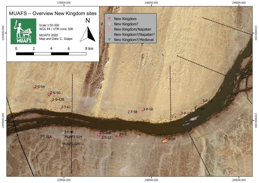
As recently outlined by Rennan Lemos, a remarkable tomb of Ramesside date was found by Vila in Ginis West. We identified this monument during our survey in 2019 and it clearly once had a tumulus superstructure; the descent to the rock-cut chambers is still visible. Some broken pottery as well as bone fragments are scattered around the superstructure, but otherwise this structure is isolated and cannot be associated with burial monuments (apart from a few Christian tombs close by).
Figure 1: Site 3-P-50 in 2019 (photo: J. Budka).
A look at the distribution map of New Kingdom sites in our MUAFS concession (see Budka 2020, 65, fig. 14) is useful for a tentative contextualisation of the tomb which, among others, yielded shabtis of the lady of the house, Isis (Vila 1977, 151). The New Kingdom sites are clustered within the southwestern part of the research area, thus close to the urban sites Amara West and Sai Island. The role of these administrative centres Amara West and Sai Island needs to be considered when looking at the ‘periphery’ (cf. Spencer 2019; see also Stevens and Garnett 2017) and might have influenced the pattern of site distribution. The latter, however, is still preliminary as I pointed out in a earlier post.
Figure 2: Distribution of New Kingdom sites in the MUAFS concession including 3-P-50, 2-T-58 and 3-P-15 (see Budka 2020, fig. 14).
The closest possible New Kingdom site located in the neighbourhood of 3-P-50 is 2-T-58. This site is a small cemetery of several tumuli which can be attributed to the Late New Kingdom and/or the Pre-Napatan period. Unfortunately, 2-T-58 was already very much destroyed and plundered in the 1970s. There is little hope that more information than gathered by Vila can be gained from these tombs (Vila 1977, 119-122, figs. 53-54).
Figure 3: One of the looted tombs of site 2-T-58 in 2019 (photo: J. Budka).
Vila excavated one of the tombs and found the remains of four burials, of funerary beds, bodily adornment like beads and amulets and some ceramic vessels which seem to date to the late Ramesside period and the Pre-Napatan phase, finding close parallels at Amara West (Binder 2014, passim) and also at Hillat el-Arab (Vincetelli 2006, passim). A post-New Kingdom date is maybe the most likely for this excavated tumulus and its interments.
Especially interesting and most probably contemporaneous to the isolated tomb 3-P-50 is site 3-P-15 in Kosha West which is part of a cluster formed by three settlement sites (3-P-15, 3-P-16 and 3-P-17).
This habitation site on a mound of c. 55-100m shows a surface covered by schist blocks and sherds. In the northeastern part, remains of mud bricks are visible. The surface ceramics we documented show a continuation from late Ramesside times well into the ninth and maybe even the eight century BCE, thus into the Napatan era.
Figure 4: Overview of site 3-P-15 in 2019 (photo: J. Budka).
A more precise dating and a concise characterisation will require excavations – but the site seems to have been in use during the time the cemeteries at Amara West flourished and 3-P-50 was built. As already pointed out by Michaela Binder, the best parallel for 3-P-50 is tomb G244 at Amara West (Binder 2014, Binder 2017, 599-606). The latter is the largest multi-chambered tomb at Amara West with a tumulus as superstructure and, like 3-P-50, also situated in what seems to have been an isolated position during the 20th Dynasty. Maybe these tombs, their architecture, their seemingly isolated location and rich equipment (which is an intriguing mixture of Egyptian- and Nubian-style material culture) point to common aspects of local elite communities in the Amara and Ginis regions we are still far away from understanding in detail.
Our planned excavations at 3-P-15 and especially the joint efforts of Rennan Lemos focusing on the mortuary evidence and Veronica Hinterhuber on the settlement remains will hopefully allow a closer assessment of the Ramesside period in the MUAFS concession and corresponding lived experiences in the near future.
References
Binder, M. 2014. Health and Diet in Upper Nubia through Climate and Political Change. A bioarchaeological investigation of health and living conditions at ancient Amara West between 1300 and 800 BC. Unpublished PhD thesis, Durham University.
Binder, M. 2017. The New Kingdom tombs at Amara West: Funerary perspectives on Nubian-Egyptian interactions, in: N. Spencer, A. Stevens, and M. Binder (eds), Nubia in the New Kingdom. Lived experience, pharaonic control and indigenous traditions. British Museum Publications on Egypt and Sudan 3. Leuven, 591-613.
Budka, J. 2020. Kerma presence at Ginis East: the 2020 season of the Munich Universit Attab to Ferka Survey Project, Sudan and Nubia 24, 57-71.
Spencer, N. 2019. Settlements of the Second Intermediate Period and New Kingdom, in D. Raue (ed), Handbook of ancient Nubia, vol. 1. Berlin, 433-464.
Stevens, A. and A. Garnett 2017. Surveying the pharaonic desert hinterland of Amara West, in: N. Spencer, A. Stevens, and M. Binder (eds), Nubia in the New Kingdom. Lived experience, pharaonic control and indigenous traditions. British Museum Publications on Egypt and Sudan 3. Leuven, 287-306.
Vila, A. 1977. La prospection archéologique de la Vallée du Nil, au Sud de la Cataracte de Dal (Nubie Soudanaise). Fascicule 5: Le district de Ginis, Est et Ouest. Paris.
Vincentelli, I. 2006. Hillat El-Arab. The Joint Sudanese-Italian Expedition in the Napatan Region, Sudan. Sudan Archaeological Research Society Publication 15. British Archaeological Reports International Series 1570. Oxford.
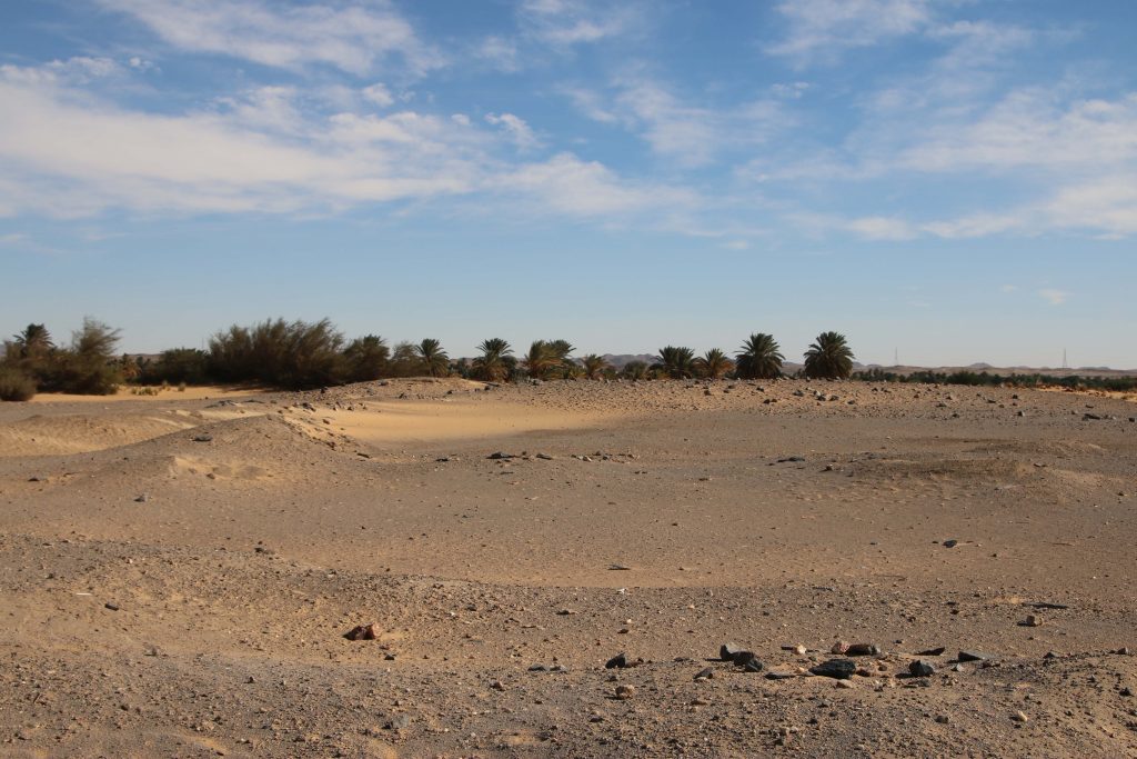
My personal favorite landscape in the MUAFS concession area is the left riverbank of the districts Ginis and Kosha which is also rich in archaeology. Beautiful sand dunes and tamarisks dominate the strip along the Nile; desert and rocky outcrops shape the hinterland.
Despite of Covid-19 and the unclear situation regarding our next field season in Sudan, we are of course planning for the ERC DiverseNile project. One of the main tasks for the next season will be test excavations at habitation sites at Kosha West.
If one looks at our new distribution map of sites dating to the New Kingdom, Pre-Napatan and Napatan times, it is striking that the most downstream ones are three sites in the district Kosha West.
Distribution of New Kingdom, Pre-Napatan and Napatan sites in the MUAFS concession.
These are remains of structures/dwellings, situated on three isolated mounds on the dune area with tamarisks. The distance to the Nile is 100-150m. This group of habitation site was already noted by André Vila in the 1970s and he attributed all of them to the Egyptian New Kingdom. This is, however, not the case.
Overview of site 3-P-17.
3-P-17 is traceable with some mud bricks and scattered stones on a mound, the total extension of the site is at present a bit unclear. According to the surface pottery we recorded last year, this site can be attributed to the early 18th Dynasty.
The remains of 3-P-16 are located on a circular mound with a diameter of c. 50m. In the south-eastern part of the mound large amount of mud bricks seem to have once formed a fortification. The dating of this structure must remain unclear for now; the surface material suggests indeed a New Kingdom date, but there were also some Medieval sherds.
Surface at site 3-P-15.
The third habitation site, 3-P-15, comprises a mound of c. 55-100m, the surface is covered by schist blocks and sherds. The appearance of the site is very similar to 3-P-16. In the northeastern part, remains of mud bricks are visible. 3-P-15 is especially intriguing because it shows a continuation from late Ramesside times well into the ninth and maybe even the eight century BC according to the surface ceramics we documented. A more precise dating and a concise characterisation will require excavations – but a New Kingdom only date as suggested by Vila seems were unlikely.
Mud brick remains at site 3-P-15.
For now, we keep our fingers crossed that the Covid-19 situation in Sudan – and of course everywhere else! – will soon improve and everybody stays healthy. Insha’allah our planned fieldwork will be possible somewhen in the near future – there are definitly plenty of things to be checked and discovered between Attab and Ferka!
The MUAFS
2020 season will be officially closed today – we arrived safely in Khartoum
yesterday and will now finish all the paperwork.
The last days at Ginis were busy, finishing off the survey, packing and registering the finds from this season. A more concise summary of the 2020 season will follow shortly, but here are some observations regarding our survey.
Like in 2019, one particular
focus of our survey was on the state of preservation of the sites nowadays –
unfortunately, at almost all sites, we observed modern destruction and/or
plundering. Especially drastic were destructions because of road building, the
electricity posts and modern gold working areas.
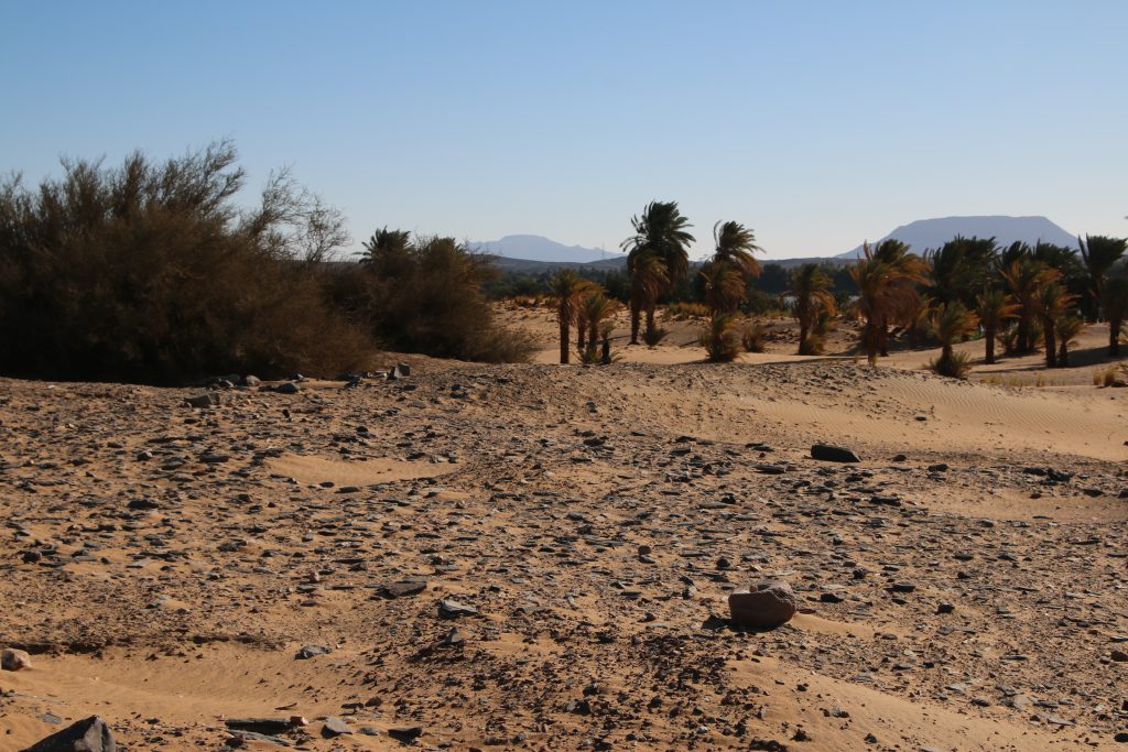
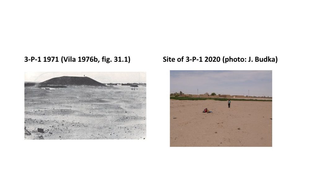
One particular striking example is the large tumulus within the Post-Meroitic site 3-P-1 at Kosha East. This monumental tumulus, comparable to the ones at Ferka, but also to the famous tombs at Qustul and Ballana, has completely gone by now. According to information kindly given by local villagers, it was removed in 2008.
One of the sad discoveries of this season: the huge tumulus at Kosha was completly dismantled.
Where Jessica is standing in this photo, there used to be an elite tomb monument dating back to Post-Meroitic times. Large parts of cemetery 3-P-1 are now under modern fields; the line of electricity cuts the southern extension of the site. The nearby Kerma cemetery was affected by the construction work of the road to Wadi Halfa and the Neolithic sites located in the hills above the Kosha plain just 300m to the southeast are strongly influenced by modern gold working.
Altogether, as successful as our 2020 survey was, re-locating 40 sites of the ones documented by Vila and finding a number of previously unrecorded sites, we were also faced with very frustrating news and massive destruction of the archaeological monuments. There clearly is the urgent need to undertake cultural heritage actions in the region, but this is something where MUAFS will need help and support from several authorities.
We are
already approaching the end of our second season of the MUAFS project.
As planned, we finished our test excavations at GiE 001 and GiE 004 earlier this week and were then busy with surveying areas of the concession on the East bank.
The marog digging activities at GiE 001 were fully documented and surface cleaning at GiE 004 yielded some interesting information regarding the possible function of the site where Kerma Classique material dominates the assemblage.
Thanks to the introduction by Cajetan before he left to Munich, we are also up-to-date regarding our 3D surface models and digital documentation– Jessica managed the processing with PhotoScan and QGis very well.
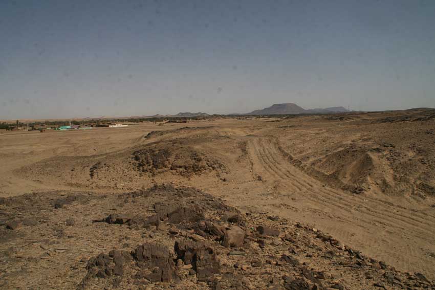
Three days of survey at Ginis, Kosha and Mograkka were exciting, but also partly very frustrating – we relocated a total of 27 sites documented by Vila in the 1970s, but unfortunately a number of these have been completely destroyed, especially because of the road construction work of the asphalt street going to Wadi Halfa. This holds in particular true for cemeteries laid out on sandy plains and alluvial platforms.
Example of changes in the landscape at Kosha East, due to the road construction and modern gold mining.
Further destruction is caused by modern gold mining and some areas of the region have been completely modified since the 1970s, making a crosscheck with Vila’s documentation sometimes were difficult. Sites located further into the hillsides were in most cases more lucky and still represent excellent example for the occupation of the region. We documented camp sites from various periods, especially Neolithic times and Kerma periods, but very often also multi-period sites.
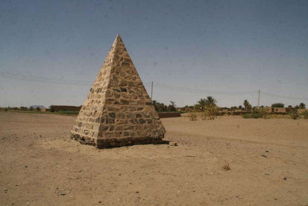
Bristish pyramidal memorial at Kosha East.
An unexpected discovery was a small stone pyramid at Kosha East – I simply did not know that one of these pyramidal memorials set up by the British in Sudan and of which I have already seen quite a number further north, was also erected in our concession. Its label reads: „To the memory of British officers and men who died here in the Anglo-Egyptian campaigns”. This memorial is not the only reminder and evidence for the Anglo-Egyptian campaigns in our area – as already observed by Vila, several of our camp sites located in the hills show traces of recent re-use. Many of these sites were probably re-used by the Anglo-Egyptian soldiers. This is one of the more modern aspects of the landscape biography of the Attab to Ferka region which we will also incorporate into our general assessment.
We will continue with the survey next week, focusing now on the area around Ferka – fingers crossed that the storm that came up tonight will hopefully cease very soon.


