I’m delighted to announce that a new publication is now available in open access. Me and my co-authors – Fabian Dellefant, Giulia D’Ercole, H. Albert Gilg, Rosemarie Klemm and Johannes H. Sterba – show how archaeometric techniques used as part of the DiverseNile Project can be used to investigate human-environment interactions in the Middle Nile during the Bronze Age.
We present case studies from our recent investigation of landscape properties in the MUAFS concession area in northern Sudan, the Attab to Ferka region, and associated material remains. We also included some materials from Sai Island, the main urban site of this region. Our article looks at different ways to combine archaeology and geology, like taking rock samples and studying the composition of sandstones (see also an earlier blog post by Fabian). It also shows how these methods can be used to understand past landscapes and mobility patterns. We’re looking at the material culture, especially ceramics, in a bunch of different ways using a bunch of different scientific methods. We’re combining compositional bulk analysis (INAA) with mineralogical (XRD) and petrographic data via optical microscopy (OM) to check out the physical properties, where the ceramics came from and how they were made (you may want to check out an earlier blog post by Giulia). We’re also using Raman spectroscopy to see what temperatures the ceramics were fired at.
This paper shows how new developments in landscape archaeology and the archaeometry of material culture are helping us to understand the big ecological and social changes that happened in the Bronze Age Middle Nile. We think this combined analytical approach, which we’ve used in the Attab to Ferka region as an example, can also be successfully used in other regions around the world.
Full reference of the new publication:
Julia Budka, Fabian Dellefant, Giulia D’Ercole, H. Albert Gilg, Rosemarie Klemm & Johannes H. Sterba, Investigating human-environment interactions in the Middle Nile: The contribution of archaeometric techniques to understanding landscape use and social practices in Bronze Age Sudan, Egypt and the Levant 35, 2025, 101−134, https://austriaca.at/0xc1aa5572_0x00412ff6.pdf
Events tend to come thick and fast at the end of the year – as was the case with our latest article, which was fortunately published yesterday despite the public holidays.
We are happy to announce that the ‘Contact Space Biography’ concept developed as part of the DiverseNile project (see already my early blog post at the start of our project) is now available in article form and will hopefully be discussed – and useful to others. We developed this concept in order to reach a higher resolution understanding of cultural dynamics and diversity of ancient Nilotic groups, taken the Attab to Ferka region as a case study. We argue that areas like the MUAFS concession can be understood as complex social spaces intertwined with an often changing landscape.
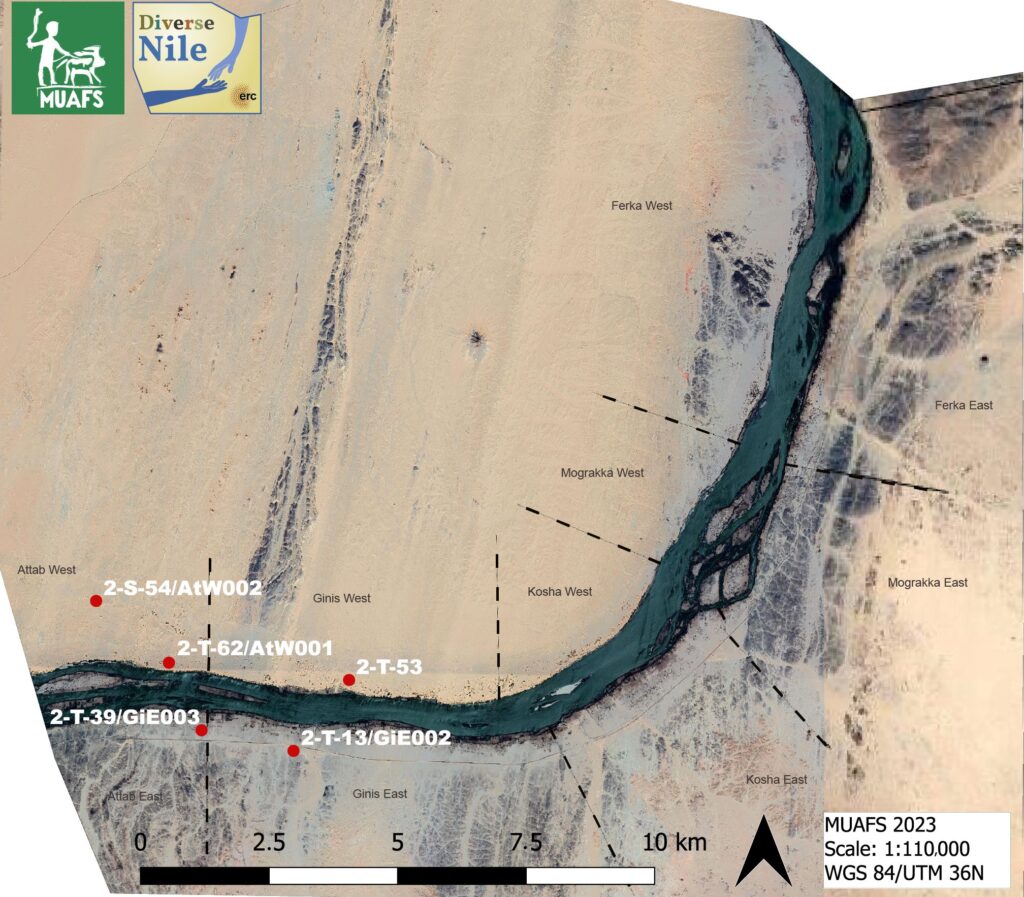
We present our findings from the study of selected cemetery and settlement sites in Attab and Ginis. The following sites are discussed in our article: cemetery GiE 003; cemetery GiE 002 and the settlement sites AtW 001, AtW 002 and 2-T-53 (cf. other “stone villages” in Attab and Ginis West). These sites range in date from Middle Kerma to the Napatan period and allow to consider the local realities of cultural interactions in rural areas, away from “central sites” such as Amara West and Sai Island, showing clear changes from the Bronze Age to the Iron Age. Read our article for more information!
MUAFS concession area showing the location of the sites discussed in our article (Map: C. Ward)
Reference:
Budka, J., Aglan, H., & Ward,C. (2025). Reconstructing Contact Space Biographies in Sudan During the Bronze Age. Humans, 5(1), 1. https://doi.org/10.3390/humans5010001
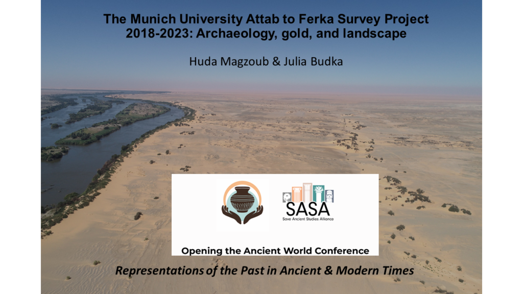
I am delighted that today there will be a joint presentation by my dear friend and colleague Huda Magzoub and me at the SASA conference. Under the title “The Munich University Attab to Ferka Survey Project 2018-2023: Archaeology, gold, and landscape” we will summarize some aspects of our work in Sudan.
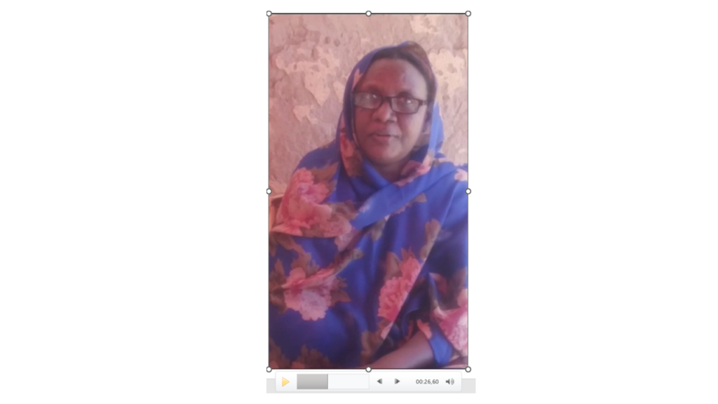
Since Huda is currently having very restricted internet, being displaced with her family in Sudan because of the current war, she sent me a video which I incorporated in the presentation. As much as it hurts not to be able to see her online or in person, it’s a wonderful feeling to present some outcome of our common work and to focus for a change on archaeology & scientific research despite of all the tragedies connected with the war in Sudan.
In our paper today, we will give an overview of the activities and results of the MUAFS project from its start in 2018 until 2023, with a special focus on new findings regarding ancient gold working in the region. In addition, modern gold working and the challenging of preserving cultural heritage in a remote area in times of war will be addressed. Thus, the presentation will follow a comparative approach to analyze gold working throughout the ages. This is especially relevant for Sudan as gold mining has been already in ancient times not just an economic activity but a testament to technological and cultural advancements. Gold has served as a catalyst for cultural evolution, economic prosperity, and sometimes conflict. We will address these aspects and thus highlight some features of the multifaceted story of gold in Sudan, tracing its influence from the dawn of civilization to the contemporary era. Finally, modern concepts of ancient gold working can be critically revisited thanks to the new evidence in the MUAFS concession, making the paper highly relevant for the general theme of the conference.
I am very grateful to the conference organizers for accepting our paper and for giving Huda as a displaced Sudanese archaeologists a forum to share her research in times of war.
The most recent publication of the ERC DiverseNile Project focuses on landscape and resource management in Bronze Age Nubia. Here, I would like to present some thoughts on the regionality of stone quarrying in Nubia with a case study from the MUAFS concession.
Stone is a natural resource which has typically been associated with Egypt, being regarded as a raw material of little importance for Nubian cultures. However, the quarrying of stone played a role in the complex framework of cultural exchange of Middle Nile communities with Egypt (see Budka 2024). Whereas Nubian sandstone (quartz sandstone) only started to be used as building material in the Middle Nile during the Middle Kingdom, mostly for Egyptian fortresses, there is evidence for a much earlier use of natural- and dry-stone architecture, in both settlement architecture and funerary buildings (cf. Liszka 2017). Sandstone architectural pieces were also well integrated within Nubian monumental architecture (e.g., the columns and stelae at the eastern Deffufa in Kerma, see Budka 2024 with references). Some of the most important sandstone quarries during the New Kingdom can be found at Sai Island – we have studies these quarries already during the ERC AcrossBorders Project and will come back to the topic within the framework of our present project in the near future thanks to the expertise of our PostDoc Fabian Dellefant.
Granite is another important stone quarried in Nubia. While the most renowned granite quarry used for building projects and objects in ancient Egypt over millennia is located in Aswan, there are also a number of granite quarry sites in the Middle Nile. They are less well known and seem to have been used for a considerably shorter amount of time.
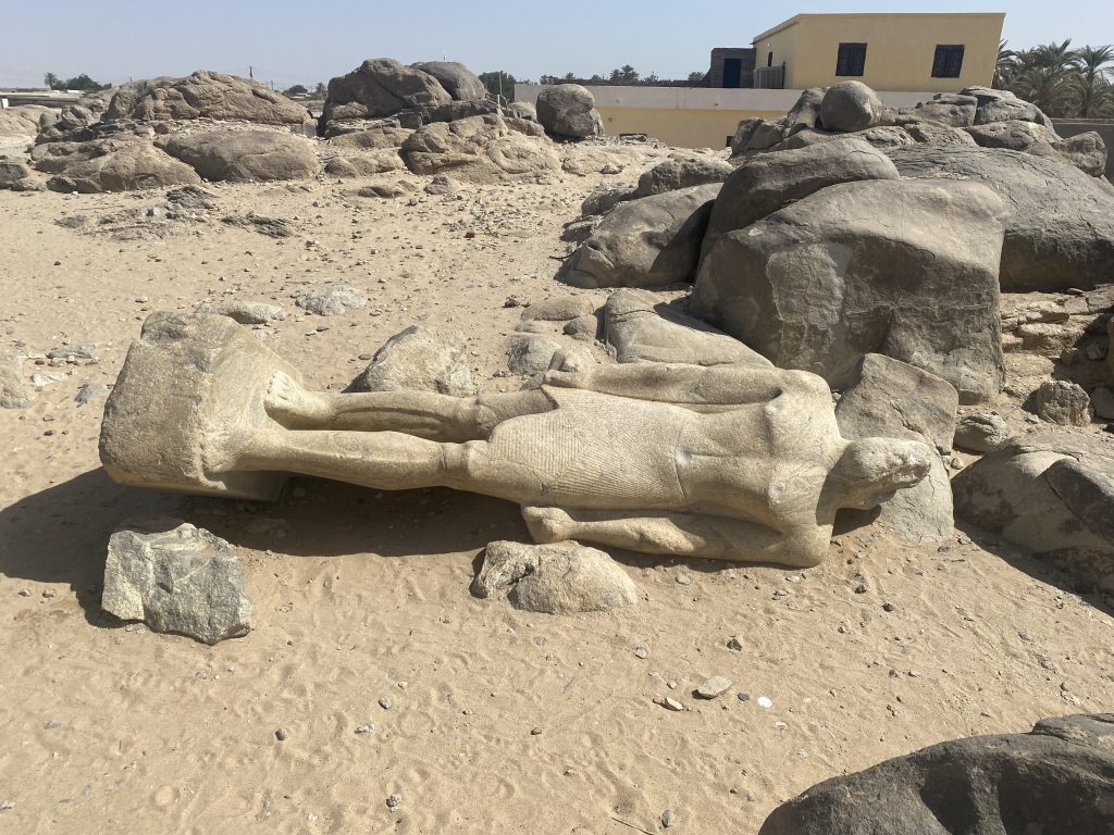
The quarry site of Tombos with an unfinished royal statue.
One quite famous example is the site of Tombos close to the Third Nile Cataract. The site includes a large quarry of magmatic rocks, principally granite and granitic gneisses, with known activity from the 18th Dynasty until Napatan and Meroitic times, particularly for statues and stelae. One particularly striking left-over in the quarry is the beautiful, although unfinished royal statue of presumably Napatan date.
There is no clear evidence that the quarry site of Tombos was used prior to the New Kingdom (Klemm, Klemm and Murr 2019, 28).
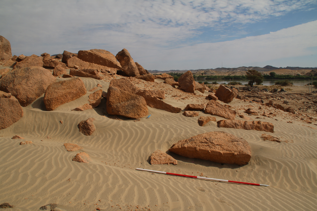
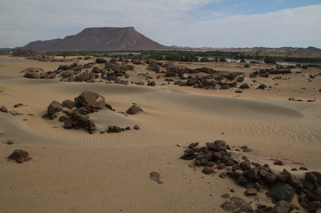
Another type of granite, pink granite, is available just south of the Dal Cataract in the MUAFS concession. This brings me to my case study: site 3-L-6 is a large red granite quarry at the foot of Jebel Kitfoggo in Ferka West – well noted by Vila and others during the 1970s survey (Vila 1976, 72−73). We visited the site during our 2022 survey of the MUAFS project – the landscape is fantastic and the pink granite very picturesque.
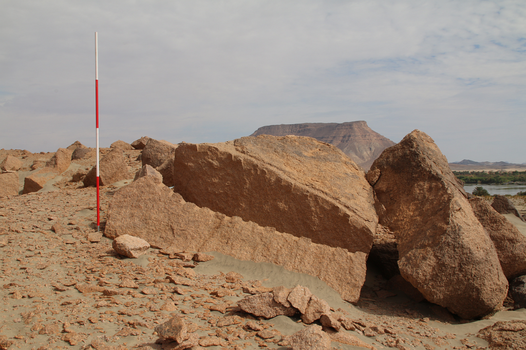
The site 3-L-6 at Jebel Kitfoggo is one of the highlights in the MUAFS concession area.A large number of stone working traces can be observed at the pink granite quarry 3-L-6.
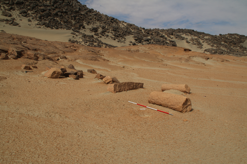
Fragments of unfinished columns in the southern part of the site testify to an intensive use in Medieval times for architectural pieces (Welsby 2002, 173).
The quarry was clearly used for architectural pieces like columns.
This is supported by evidence from settlement site 3-G-30, just to the north of 3-L-6, where Medieval ceramics were found on the surface. The building technique and general layout of these stone-built huts are also typical of the Medieval era.
Part of site 3-G-30 in close vicinity of the granite quarry.
Although several Kerma sites are also identifiable in the surroundings of 3-L-6, there is no evidence for Bronze Age or Iron Age use of the granite quarry at Jebel Kitfoggo.
It is interesting to stress that both Tombos and Jebel Kitfoggo were used for a relatively limited time span compared to other quarry sites. These examples illustrate regional patterns in quarrying in the Middle Nile, but they also show the need to consider political and historical circumstances when investigating the management of raw material and resources (Budka 2024).
References
Budka 2024 = J. Budka, Introduction. Regionality of resource management in Bronze Age Sudan: an overview and case studies, in: J. Budka and R. Lemos (eds), Landscape and resource management in Bronze Age Nubia: Archaeological perspectives on the exploitation of natural resources and the circulation of commodities in the Middle Nile, Contributions to the Archaeology of Egypt, Nubia and the Levant 17, Wiesbaden 2024, 19−33.
Klemm, Klemm and Murr 2019 = Klemm, D., Klemm, R. and Murr, A., Geologically induced raw materials stimulating the development of Nubian culture, in: D. Raue (ed.), Handbook of Ancient Nubia, Vol. 1, Berlin; Boston 2019, 15−38.
Liszka 2017 = Liszka, K., Egyptian or Nubian? Dry-stone architecture at Wadi el-Hudi, Wadi es-Sebua, and the Eastern Desert, Journal of Egyptian Archaeology 103 (1) (2017), 35−51.
Vila 1976 = Vila, A., La prospection archéologique de la Vallée du Nil, au Sud de la Cataracte de Dal (Nubie Soudanaise). Fascicule 3: District de Ferka (Est et Ouest),Paris 1976.
Welsby 2002 = Welsby, D.A., The Medieval Kingdoms of Nubia: Pagans, Christians and Muslims Along the Middle Nile, London 2002.
The excavation season of the fourth MUAFS campaign lasted from January 23 to March 18 2023, and focused on aims of the ERC Project DiverseNile, investigating Bronze Age sites (Kerma and New Kingdom) and cultural diversity in the region. The team was supported by Huda Magzoub Elbashir as Antiquities Inspector from NCAM. Our major activities in the 2023 season are summarised in the following.
Excavations
We focused on Bronze Age sites in the area of Ginis and Attab. Our selection included two settlement sites, AtW 001 and site 2-S-54, and one cemetery, GiE 003. Work was carried out with the support of a team of 12 local workmen from Ernietta, Ginis and Attab.
AtW 001
In 2023, the complete mound of this site in Attab West was excavated (Trench 2). Substantial layers of mud brick collapse were found as well as several phases of poorly preserved mud brick structures.
Location of Trench 2, situation before the excavation in 2023.
The domestic character of the site is also obvious from many ashy spots, rubbish deposits including much animal bones and charcoal as well as loads of broken pottery and a surprisingly large number of intact and almost intact vessels. In addition, several round and oval-shaped storage pits were documented, some of them with traces of firing/ash and possibly also connected with heating/cooking.
Most importantly, the same ashy layer on the alluvial surface like in 2022 was reached in the northern part of Trench 2. It is now clear that apart from a slight natural slope, most of the mound-like appearance of site AtW 001 was composed of settlement debris and especially mud brick debris in several layers, all dating to the 18th Dynasty.
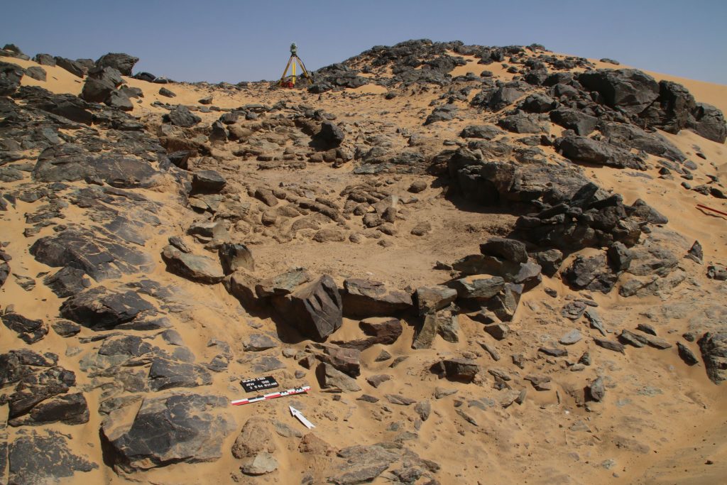
Vila site 2-S-54
Structure 1 at site 2-S-54 is a domestic building measuring 6.5 x 3.5m on the interior and preserved to more than 80cm in height, datable to the 18th Dynasty. We cleaned it from windblown sand and exposed a substantial layer of mud brick debris as well as internal mud brick structures. The feature seems to have been divided in at least three parts, presumably with an open courtyard in the centre. It is still unclear where the main entrance of the structure was originally located (one side entrance seems to have been on the east side in the centre, leading into the open courtyard). Ceramics and collapsed mud bricks were also found on the slope towards the south and this area still needs to be fully cleaned and documented.
Structure 1 at 2-S-54 shows an intriguing mix of stone and mud bricks as building material.
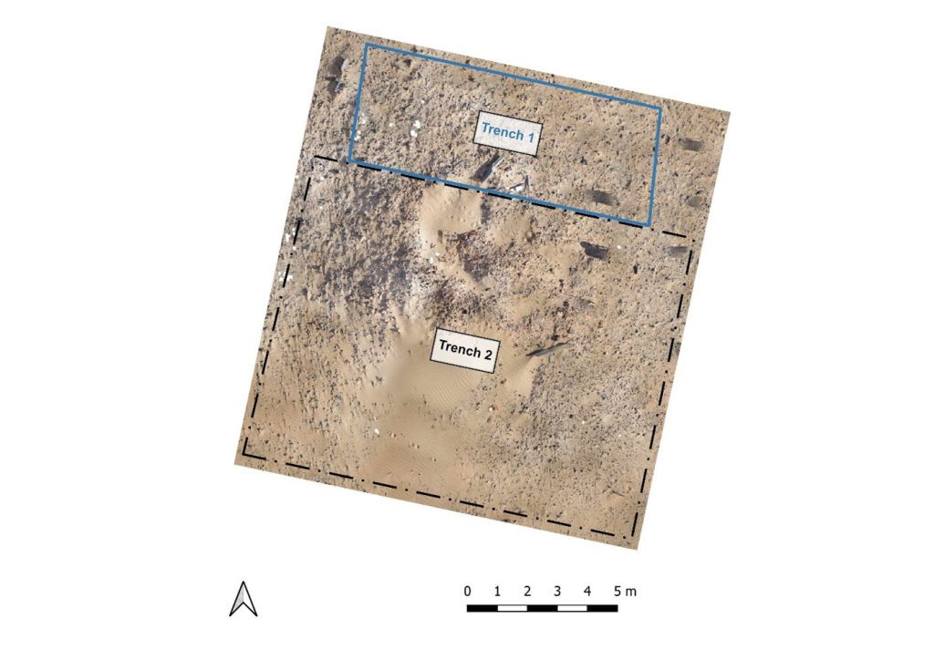
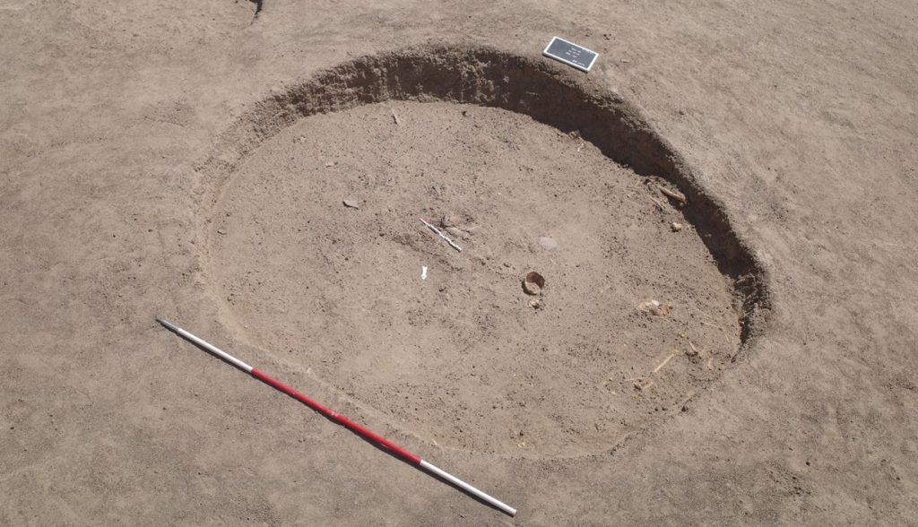
GiE 003
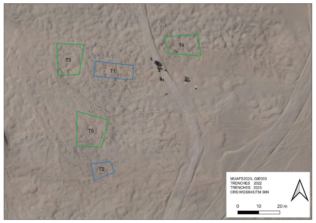
We excavated three new trenches (Trenches 3, 4 and 5) to check the extension of this Kerma cemetery, the distribution of burial types and chronological aspects.
Location of the trenches excavated in GiE 003 in 2023 (including the 2022 trenches in blue).
The oldest material was exposed in Trench 5, just north of the Middle Kerma burials in Trench 2. One Middle Kerma circular pit (Feature 53) and a total of four pits associated with Pan-grave style material were discovered.
The largest pit, Feature 50, contained the remains of a wooden bed frame, the remains of a human contracted burial, several goat offerings and a considerable number of intact pottery vessels, comprising Black-topped fine wares as well as incised and impressed decorated vessels.
Feature 50, the Pan-Grave burial pit (second situation with goat offerings and complete pots).
Trench 3 yielded a total of 14, Trench 4 ten new Classic Kerma burial pits, closely resembling our results from 2022 in Trench 1. These burials are rectangular east-west oriented burial pits with rounded corners, vertical walls, and two depressions in the east and west for the funerary bed of which wooden remains were found in some of the features. Two niche burials in Trench 4 also seem to date to the Classic Kerma time.
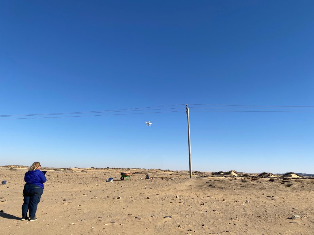
Drone Aerial Photography
Kate Rose was busy conducting Drone aerial photography (DAP) at the excavated sites and on a larger scale at Attab West, Attab East, Ginis East and Ferka East. Many precise measurements were taken with our new Trimble Catalyst GNSS Antenna and extensive mapping of drystone walls in Attab and Ginis West was carried out as well.
Kate documenting the final state of AtW 001 with our drone.
Find documentation
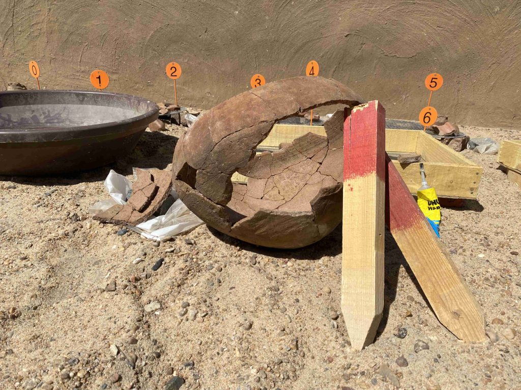
We used a total of 566 find bag numbers in the 2023 spring season. 229 finds were registered, photographed and recorded in detail in the Filemaker Database.
One of the highlights of the ceramic processing 2023: a complete cooking pot from AtW 001 reconstructed from many fragments.
Simultaneously to the excavations, I carried out the recording of the pottery. The numerous settlement material from AtW 001, accounting to more than 10.000 sherds, was very time consuming to process, especially since a large number of pottery vessels could be reconstructed from fragments to complete vessels like an amazing hybrid cooking pot. A total of 43 vessels was documented by drawing in 2023.
The 2023 season survey
Two Vila sites in Attab West and one in Kosha East were newly identified and documented as well as seven new MUAFS site in Attab East, Attab West and Kosha East. A number of these sites is difficult to date and might be sub-recent.
In sum, our 2023 season was very successful, achieving all planned work tasks despite of the looting events and the destruction of site 2-S-54. Especially cemetery GiE 003 with its mixed material culture of Middle Kerma, Pan-Grave and Classic Kerma illustrates cultural encounters between various Nubian groups in the region. The living aspect of these cultural encounters seems to be traceable at sites like 2-S-54 where both Egyptian and Nubian ceramics were found, rectangular and circular buildings appear side by side and mud bricks were used jointly with dry-stone architecture.
Plenty of post-excavation work is now waiting for us and updates will follow soon.
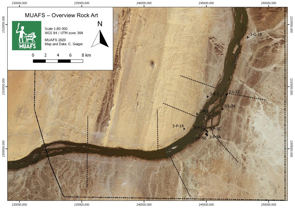
Rock art in Sudan has become one of my favourite topics ever since I worked in the Fourth Cataract region in the 2000s. Within the MUAFS concession between Attab and Ferka, there are not many sites with rock drawings. Unsurprisingly, rock art is restricted to certain areas with fitting geology and large boulders – in our concession these are the districts of Ferka, Mograkka and Kosha (Fig. 1). Close to Mograkka, one particularly handsome engraving was chosen as the basis for the MUAFS logo.
Fig. 1: Map with rock art sites located in the MUAFS concession (status 2020).
Some of these sites are located in close proximity to Kerma funerary sites. This holds especially true for 3-P-14 (Kosha West), 3-G-18 (Ferka East) and 3-P-5 (Kosha East).
3-G-18 is located on rocky outcrops within the large plain of Ferka and directly adjacent to the Kerma cemetery 3-G-16 (Fig. 2). Kerma cemetery 3-G-19 is also not far away. These sites are of particular interest because they are the northernmost Kerma sites in our concession.
Fig. 2: Map showing the close relations between Kerma cemetery 3-G-16 and rock art site 3-G-18.
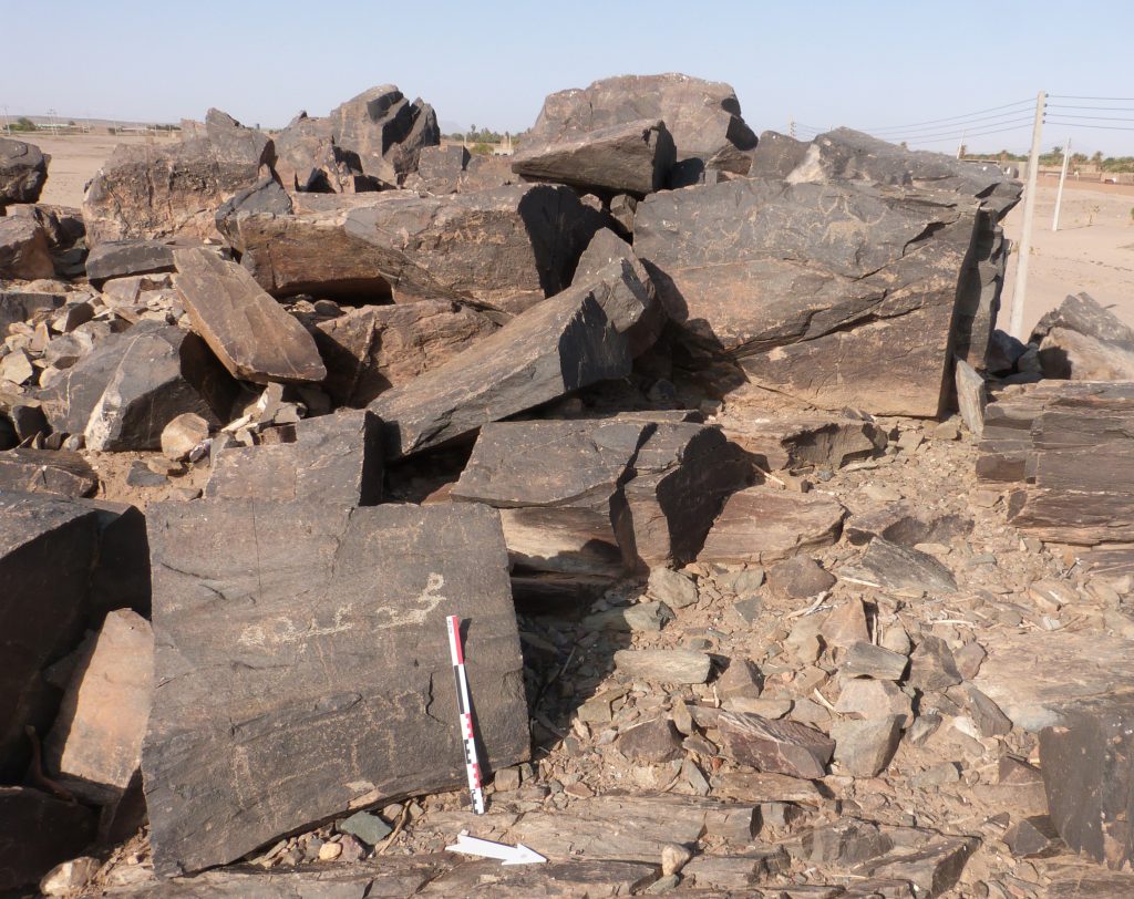
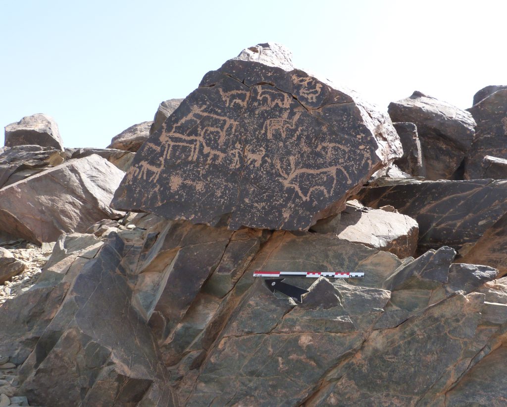
The largest rock art site is located at the border between Mograkka and Kosha East, site 3-P-5, with more than 400 individual rock art pictures (Vila 1976, 79‒87). The motifs comprise mostly cattle, antelopes, some human depictions, birds, dogs and other animals (Figs. 3-4).
Fig. 3: Example of rock engravings in 3-P-5. Cattle is the most frequent motif.Fig. 4: Example of rock engravings in 3-P-5. This boulder shows cattle, but also birds, humans and possibly a dog.
While Vila left the dating as unclear, most of the rock art pictures at 3-P-5 seem to belong to the Kerma period (Budka 2020). Similar to 3-G-18 in Ferka, there are Kerma sites in the close proximity to 3-P-5 which support this dating.
In all phases of the Kerma culture, the dominant motif of rock art is cattle. Of course this reflects the importance of cattle herding to Kerma people – some aspects of which were recently addressed by Jérôme Dubosson at one of our DiverseNile Seminar Series 2022. In the words by Louis Chaix: “Cattle are a key constituent element of the civilization of Kerma. They played a major role in the diet of the population and as a source of secondary products such as milk, hides, and raw materials for making tools. They also contributed to agriculture as traction animals.” (Chaix 2017). Within the DiverseNile project, we aim to address the local role of cattle for the Kerma people by means of a multidisciplinary approach, combining landscape archaeology with bioarchaeology and of course analysing all kinds of archaeological findings like animal bones, animal figurines and engraved figures of cattle in rock art.
Coming back to the question of rock art, the spatial proximity of rock art panels depicting cattle and Kerma funerary sites was already noted by Cornelia Kleinitz in the Fourth Cataract region (Kleinitz 2007). As tempting as it is to link these rock drawings with Kerma funerary cult, at the Fourth Cataract and also in the MUAFS concession, a precise dating of cattle depictions in rock art often remains impossible.
Nevertheless, we will soon be back in the field in Sudan – one of the goals for the 2023 season is to expand the documentation of rock art in our concession, with a special focus on possible Kerma sites. Contextualising rock art sites clearly has much potential for a closer understanding of their date and function.
References
Budka, Julia 2020. Kerma presence at Ginis East: the 2020 season of the Munich University Attab to Ferka survey project. Sudan & Nubia 24, 57-71.
Chaix, Louis 2017. Cattle: a major component of the Kerma culture (Sudan). Edited by Umberto Albarella, Mauro Rizzetto, Hannah Russ, Kim Vickers, and Sarah Viner-Daniels. Oxford Handbooks Online 2017 (April), 15 p.; 4 figs. DOI: 10.1093/oxfordhb/9780199686476.013.2
Kleinitz, Cornelia 2007. Rock art and archaeology: the Hadiab survey. Sudan & Nubia 11, 34-42
Vila, André 1976. La prospection archéologique de la Vallée du Nil, au Sud de la Cataracte de Dal (Nubie Soudanaise).Fascicule 4: District de Mograkka (Est et Ouest), District de Kosha (Est et Ouest). Paris.
Four years have passed since the last International Conference of Nubian Studies in Paris and on Sunday, the 2022 edition of the 15th congress will start in Warsaw.
Rennan, Chloë and I will be attending, and I will present the MUAFS project and its main results of the last years. My paper will give an overview of our activities from 2018 until 2022, with a special focus on the ongoing subproject ERC DiverseNile focusing on the Bronze Age remains. I will introduce our landscape biography approach in the Attab to Ferka region as the investigation of encounters of humans and landscapes in a peripheral borderscape with a longue-durée perspective, considering all attested finds from Palaeolithic times until the Islamic age.
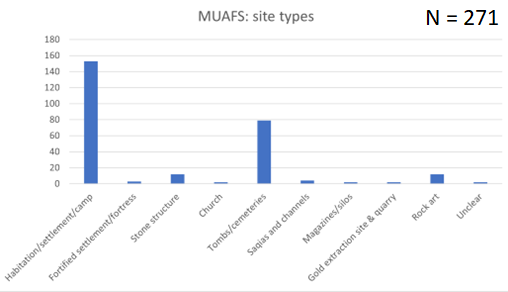
For the presentation, I updated our list of sites and processed some of the quantitative data. At present, a total of 266 sites was documented. This comprises 186 of the 219 Vila sites as well as 80 newly identified sites. This number of sites is still preliminary because parts of Kosha, Mograkka and Ferka on the West bank have not yet been surveyed.
Regarding the types of sites, the most common sites are settlements and burial grounds. However, it is also remarkable that the MUAFS concession includes one granite quarry, one gold extraction site and several rock art sites.
Main types of sites in the MUAFS concession (status 2022).
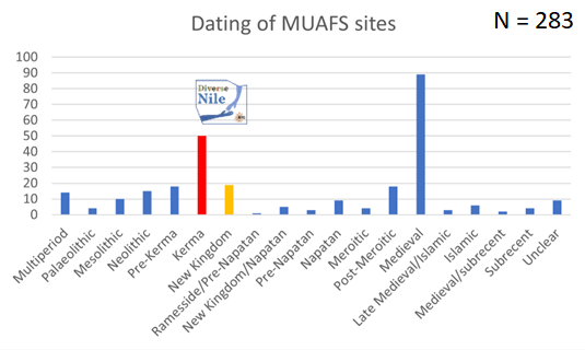
As far as the dating of the sites in concerned, the majority belongs to the Medieval time. However, Bronze Age sites, here labelled as Kerma and New Kingdom sites, which are relevant to the DiverseNile project are also well represented. There are also several multi-period sites and others were re-used in later periods (e.g. Kerma sites in Medieval times).
Dating of the MUAFS sites. Note that the total number of sites for this table is 283 since several sites were used in more than one period. The Kerma and New Kingdom sites are currently being investigated by the DiverseNile project.
I will also present some general patterns of the distribution of sites throughout the ages. This allows to highlight the importance of environmental parameters and changing landscapes in the region.
Although my last visit to Warsaw was just in May this year, I cannot wait to be back in this beautiful town. I am very much looking forward to the Nubian conference and meeting all the international colleagues working in Sudan.
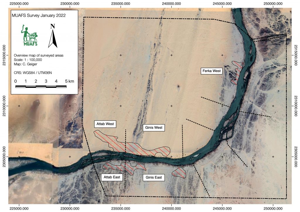
We have returned safely from Sudan and our short preparation season of the Munich University Attab to Ferka Survey Project (MUAFS) in its research concession between Attab and Ferka from Dec. 29 to January 9 was very successful.
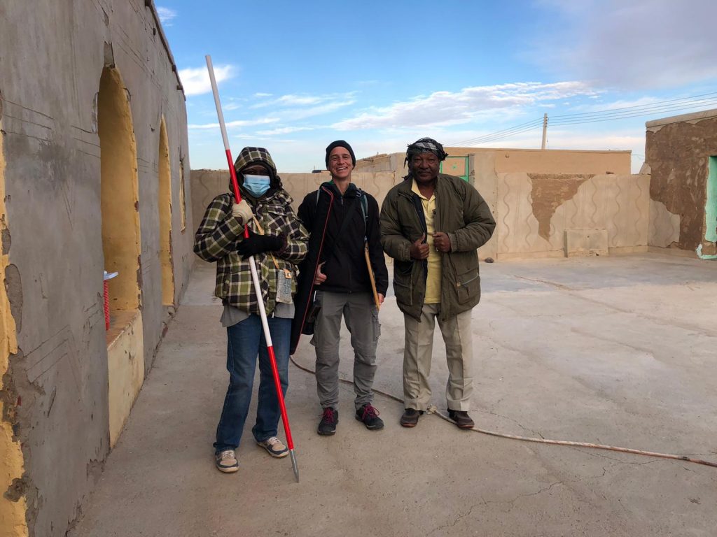
Huda, our driver Saif and I getting ready to leave for another day of surveying the area (photo: C. Geiger).
Huda and I conducted a foot survey in areas of Attab East, Attab West, Ginis East, Ginis West and Ferka West. The focus was on the identification of sites already recorded by Vila. We were able to document a total of 79 sites, comprising 21 new MUAFS sites. The sites range in date from Palaeolithic times to the Medieval and Ottoman eras. The types of sites are mostly camp sites, habitations, and tombs/cemeteries, but also include rock art and stone wadi walls.
Surveyed area of the 2021/2022 season (map: C. Geiger).
Whenever possible, we collected diagnostic pottery and lithics from the sites for dating purposes. I was able to document most of them by photography and also managed to draw 35 Kerma and New Kingdom sherds. Most interesting are some newly documented New Kingdom sites, attesting to both a use in the 18th Dynasty and a Ramesside presence in the periphery of Amara West.
One example of a newly documented site, unfortunatly recently plundered (photo: J. Budka).
One particularly striking site, a cluster of cleft tombs at Ginis East, has never been documented before but was unfortunately lately plundered. And this is not an isolated example! Recent plundering, modern gold working, new electricity lines and damaged caused by car tracks, roads and new buildings are unfortunately very frequent, have increased since 2020 and stress how urgently we need to document this rich area in the Middle Nile.
The surveying campaign carried out by Cajetan resulted in the setup of new benchmarks using a GPS Antenna and a totalstation in Attab East, Ginis East and Ginis West. We will use these benchmarks as basis for future measurements during our planned excavations. Drone aerial photography was successfully conducted in Ginis East, Ginis West and Ferka West.
All in all, I am very grateful to the support of our Sudanese friends and colleagues – without them our work at site would not have been possible in these very difficult times of political changes. We collected a large amount of new data and will now be very busy processing these here in Munich – and of course we will keep you updated.
We are very pleased to announce the DiverseNile Seminar Series for 2022. As a follow up of this year’s event, we will now focus on material culture and society in Bronze Age Nubia and respective perspectives from landscape and resource management.
It is my pleasure to open the Seminar Series on January 25 with an introduction and some ideas about global networks and local agents in the Middle Nile. Middle Nile contact space biographies we are currently reconstructing for the Attab to Ferka region provide a complex picture of a social space as a home to diverse groups and actors, rather than a static landscape and the periphery of centre-oriented narratives of New Kingdom Nubia. Our aim within the DiverseNile project is to decode, through our interdisciplinary studies, the economic role of the Attab to Ferka region for the principal centres, as a production area, and as land for animal husbandry and agriculture as well as for mining activities and gold production.
Rennan Lemos managed to gather a splendid group of speakers for the talks, covering a large set of topics from pottery technology to animal husbandry, gold extraction and much more.
We are looking much forward to this event and registration for the online DiverseNile Seminar Series 2022 is already open! Hoping to see many of you there – we will keep you updated about the specific schedule of the talks (always Tuesday, 1pm CET)!
Before we’re able to go to the field, a lot of work on the cemeteries in our concession area is currently underway from Munich. Marion’s recent blog posts already discussed the potential of magnetometry for us to better understand what we are dealing with, and this is especially true in connection with Cajetan’s remote sensing work. Cajetan’s work has been revealing some interesting aspects of our sites and hopefully you’ll be able to catch glimpses of his work soon in here.
This work provides important background regarding the specificities of our sites. Alongside an assessment of the cemeteries and comparison with other sites across Nubia, this allows us to put together an ‚ideal type‘ (sensu Max Weber) that can guide us through future survey and excavation. The data sets produced by Vila, as well as previous MUAFS seasons, are also crucial for us to establish this ideal type, which works as a methodological tool to confirm our hypotheses (or not).
In my previous posts, I’ve already shared details about the assessment of sites I’ve been carrying out over the past months. Base on Vila’s data, we can know what to expect from the cemeteries in terms of preservation, types of structures etc. For example, the Late New Kingdom „tomb of Isis“ works an example of „elite“ or „sub-elite“ burial ground in the periphery of temple towns, where Egyptian and Nubian features mixed, probably to a greater extent than at temple towns—an example of hypothesis that we can create departing from an ideal type. This mixture occurred, for instance, in the combination of Egyptian substructures and a tumuli superstructure, remains of which were located in previous MUAFS seasons (see my previous posts). Departing from an ideal type such as the „tomb of Isis“ we can approach how the ideal varies across geographical and social spaces within our concession area.
For example, Marion and Cajetan’s work are shedding light on the extension of cemeteries where we can easily see from above those tumuli, some of which already explored by Vila, but also other features. It is difficult to determine from a distance what is the nature of this evidence. Comparative research then comes in handy. I’ve already proposed a discussion on the whereabouts of the majority of the Nubian population during the New Kingdom (a discussion that also applies to the Kerma period).
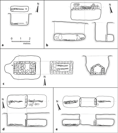
Figure 1: tomb types at Fadrus, adapted from Spence 2019, based on Säve-Söderbergh and Troy 1991.
Other Nubian cemeteries such as Fadrus in Lower Nubia add information about non-elite groups to our ideal type (figure 1). If larger tumuli such as the „tomb of Isis“ are easily located based on drone and satellite imagery, simple non-elite pit graves originally with no extensive superstructures pose more challenges. Though, comparisons allow us to open up to possibilities that include, in our research framework, social groups not clearly represented by evidence accumulated from large temple-town cemeteries. These groups—which comprised the bulk of Nubian populations working in the fields, mines, and probably carrying out other work in the service of larger centres—are yet to be fully understood (and here work at the cemeteries of Amarna provide us interesting comparison points, see Stevens 2018).
Several are the challenges of doing research from the office, as we cannot yet go to the field. But work conducted so far, from various fronts, help us establish a pretty solid starting point from which to explore our sites knowing more or less what to expect. This takes into account old and new evidence, extensive comparisons with other sites and a clear theoretical framework, which is essential to formulate research questions and carry out large scale projects such as DiverseNile.
References
Säve-Söderbergh and Troy 1991. New Kingdom pharaonic sites: the finds and the sites.
Spence 2019. New Kingdom burials in Lower and Upper Nubia. In Handbook of Ancient Nubia, ed. D. Raue.
Stevens 2018. Death and the city: The cemeteries of Amarna in their urban context. Cambridge Archaeological Journal 28 (1): 103–126. doi:10.1017/S0959774317000592


