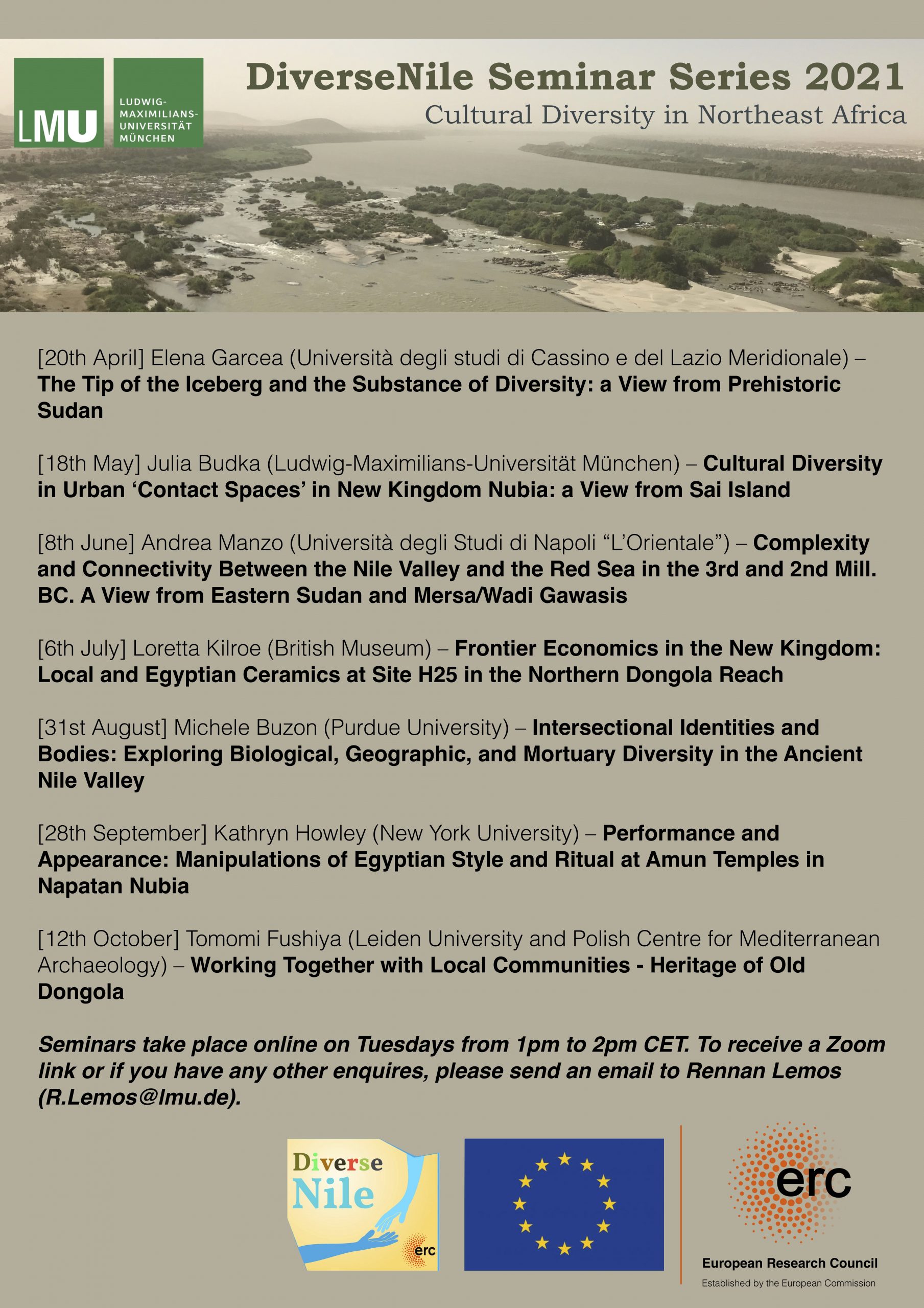
I am delighted that today there will be a joint presentation by my dear friend and colleague Huda Magzoub and me at the SASA conference. Under the title “The Munich University Attab to Ferka Survey Project 2018-2023: Archaeology, gold, and landscape” we will summarize some aspects of our work in Sudan.
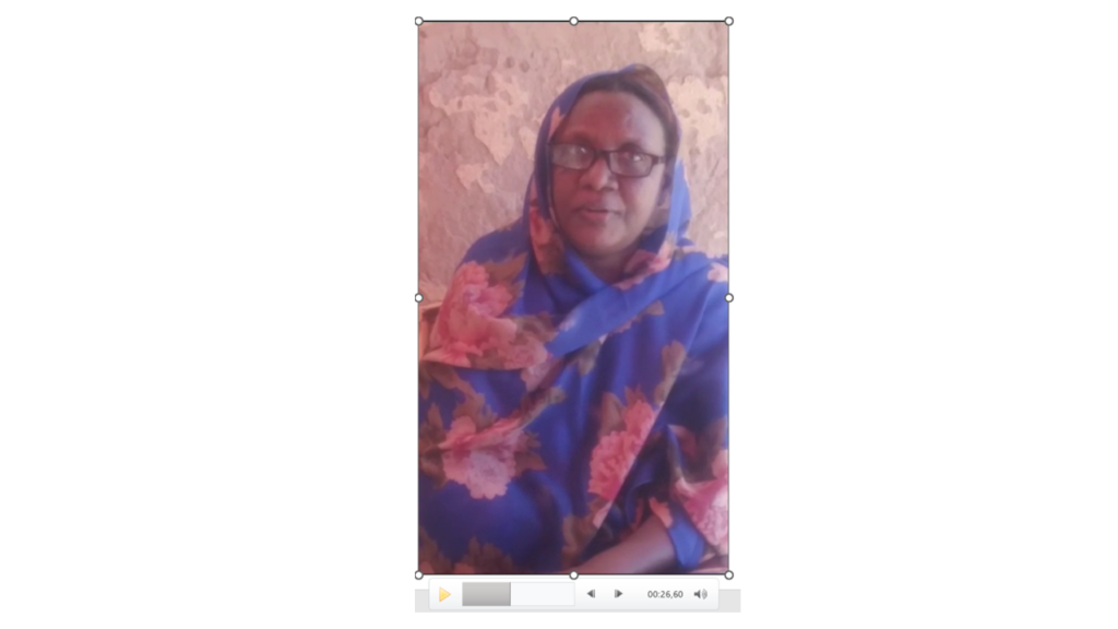
Since Huda is currently having very restricted internet, being displaced with her family in Sudan because of the current war, she sent me a video which I incorporated in the presentation. As much as it hurts not to be able to see her online or in person, it’s a wonderful feeling to present some outcome of our common work and to focus for a change on archaeology & scientific research despite of all the tragedies connected with the war in Sudan.
In our paper today, we will give an overview of the activities and results of the MUAFS project from its start in 2018 until 2023, with a special focus on new findings regarding ancient gold working in the region. In addition, modern gold working and the challenging of preserving cultural heritage in a remote area in times of war will be addressed. Thus, the presentation will follow a comparative approach to analyze gold working throughout the ages. This is especially relevant for Sudan as gold mining has been already in ancient times not just an economic activity but a testament to technological and cultural advancements. Gold has served as a catalyst for cultural evolution, economic prosperity, and sometimes conflict. We will address these aspects and thus highlight some features of the multifaceted story of gold in Sudan, tracing its influence from the dawn of civilization to the contemporary era. Finally, modern concepts of ancient gold working can be critically revisited thanks to the new evidence in the MUAFS concession, making the paper highly relevant for the general theme of the conference.
I am very grateful to the conference organizers for accepting our paper and for giving Huda as a displaced Sudanese archaeologists a forum to share her research in times of war.
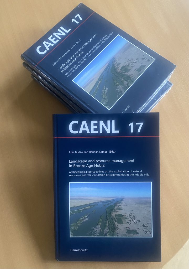
I am very proud to announce the publication of a new volume of the ERC-funded DiverseNile Project: the copies of Landscape and resource management in Bronze Age Nubia: Archaeological perspectives on the exploitation of natural resources and the circulation of commodities in the Middle Nile, Contributions to the Archaeology of Egypt, Nubia and the Levant 17, Harrassowitz Verlag, 2024, edited by Rennan Lemos and me have just arrived and simply look great!
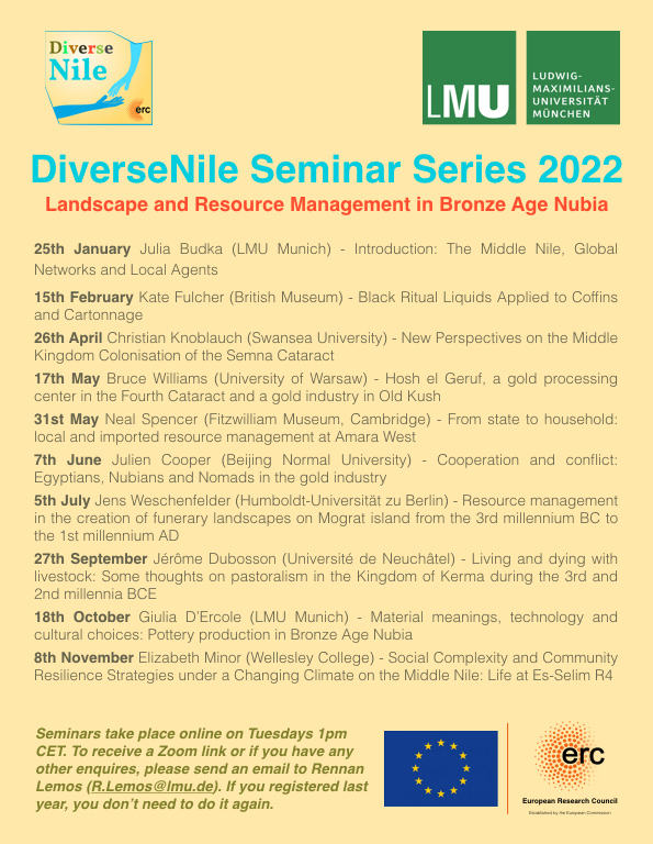
This volume is a direct result of many discussions held in the first DiverseNile seminar series organised by Rennan Lemos in 2021 as well as the second one in 2022, partly co-organised by Chloë Ward. The input of various colleagues working on several aspects of research extraction and management in ancient Nubia provided an opportunity to further develop an idea originally focused on gold into a collective effort to understand Nubian resource management in the Bronze Age. We are deeply grateful to all contributors to this volume, whose work illustrates the rich potential for a better understanding of how resources were extracted, managed, and utilised in complex ways in Nubia by various groups, including both Egyptians and indigenous communities, but also desert nomads. The table of content of the volume can be found here.
We are especially grateful to Manfred Bietak and the CAENL editorial board for accepting this volume for publication in their series and for organising the peer review. The publication was finalised in a difficult time for Sudan as a result of the conflict between the Sudanese Armed Forces and the Rapid Support Forces. As much as we are delighted to offer a further contribution to the investigation of ancient Sudan, we are also deeply concerned about the risks the people and the cultural heritage of Sudan are facing.
We fully support all our friends and colleagues in Sudan and would like to express our appreciation for their commitment to the preservation of the Sudanese cultural heritage in these extremely challending times. With the first anniversary of this terrible conflict and humanitarian tragedy approaching, it is timely to renew our concerns about and thoughts with the Sudanese people. Peace for Sudan!
As announced last week, the first preliminary report about Kerma cemetery GiE 003 in Attab/Ginis East has just been published (Budka 2022).
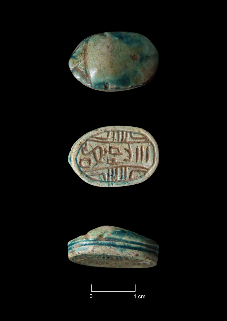
Today, I would like to discuss one of the highlights from this cemetery which was published in the EVO paper: a glazed steatite royal scarab with the name of a Hyksos king.
Found in Feature 4, the name of Pharaoh Y’amu is given on the bottom of this piece, MUAFS 005. Already on the day of its discovery, Manfred Bietak kindly helped remotely with the initial reading of the royal name of this scarab – many thanks for this! I am also particularly grateful to Karin Kopetzky, who provided detailed information about the dating criteria of this piece. The design of its back, head, legs, and sides all directly correspond to other known attestations of Y’amu (Tufnell 1984, 32, 35, 37, pl. 61: 3416, 3417, 3418, 3419; Ward 1984, 164) whose exact position within the sequence of 15th Dynasty rulers is unfortunately not clear (see Ben-Tor 2007, 107-108).
Scarabs are in general rare in cemetery GiE 003 and only two pieces have been found in our excavations. The context of scarab MUAFS 005, Feature 4, appears to belong to the later part of the Classic Kerma period, possibly contemporaneous with the Theban 17th Dynasty. As is known from other marginal regions of the Kerma empire like the Fourth Cataract area, our Hyksos scarab might have been circulating in Nubia for some time before ending up in GiE 003’s Feature 4.
The Hyksos king Y’amu has not been attested to in Nubia before the discovery of his scarab MUAFS 005 in GiE 003. Interestingly, in Ward’s sequence he would postdate the other Hyksos rulers attested to at Sai and Kerma as well as at the northern sites. Ward (1984, 164) placed Y’amu in the second half of the 15th Dynasty, but this sequence has been discussed and is not archaeologically confirmed (Ben-Tor 2007, 108 with references).
The textual evidence for contact between Kerma rulers and Hyksos kings has already been addressed from a variety of perspectives. In this context, the appearance of Tell el-Yahudiyeh ware in Nubia and of Kerma wares in Egypt, especially at the Hyksos capital Avaris, were also noted as possible indicators of exchange. Alexander Ahrens and Karin Kopetzky recently examined the appearance of Hyksos scarabs in the context of Kerma burials (Ahrens, Kopetzky 2021). Royal Hyksos scarabs are known from Ukma, Akasha, Sai, and Kerma, as well as several Lower Nubian sites (Aniba, Dakka, Sayala, Masmas, Faras, Mirgissa, Uronarti and Debeira). All of the kings mentioned on these sealings ruled during the early Hyksos period, and it is logical to assume that this was when the Hyksos engaged in direct trade with the Kerma kingdom (Ahrens, Kopetzky 2021, 295 with references and discussion). During the early Second Intermediate Period, the fortresses in Lower Nubia were under Kerma control, and the Hyksos were probably keen to establish trade and direct contact to achieve “continued access to resources and particularly to the Nubian gold essential for trade in the Eastern Mediterranean” (Ahrens, Kopetzky 2021, 295). The Lower Nubian fortresses have always been linked to gold mines and access to gold – recent work has stressed also the importance of Kerma gold working sites in Batn el-Haggar (Edwards 2020, 406-407; 415), and the same is likely for the Attab to Ferka region, especially for Ginis and Kosha. Could the Hyksos scarabs found at Ukma, Akasha, and Sai reflect not only international trade but also, indirectly, gold exploitation between the Second and Third Cataracts during Kerman rule? And could the same apply for the newly found scarab in Ginis?
It is tempting to assume that this new Hyksos scarab can be seen in connection to an intense period of Kerman exchange with the Hyksos kingdom, which sought gold from not only former Egyptian fortresses in Lower Nubia but also sites further south under Kerma rule. Sai’s importance during the Kerma Period might be linked to both the island’s strategic position and its location in a gold-rich region, making it ideal for supervising gold exploitation as we know it from the New Kingdom. Maybe the halting of trade with the Hyksos in the second part of the 15th Dynasty was one of the reasons why the character of Sai as a Kerman stronghold changed during Classic Kerma times (for this change see Gratien 2014; Manzo 2016). It remains to establish possible changes towards the end of the Classic Kerma period in marginal regions like Ginis – and cemetery GiE 003 with its use from Middle Kerma to Classic Kerma times and its close proximity to gold exploitation sites (as well as its connection to desert nomads presumably involved in the gold trade) has here lots of potential for future analysis.
References:
Ahrens, Kopetzky 2021 = A. Ahrens, K. Kopetzky, “Difficult times and drastic solutions: the diffusion of looted Middle Kingdom objects found in the northern Levant, Egypt and Nubia”, in M. Bietak, S. Prell (eds), The enigma of the Hyksos, volume IV: Changing clusters and migration in the Near Eastern Bronze Age. Collected papers of a workshop held in Vienna 4th-6th of December 2019, Wiesbaden 2021, 253-313.
Ben-Tor 2007 = D. Ben-Tor, Scarabs, Chronology, and Interconnections: Egypt and Palestine in the Second Intermediate Period, Fribourg, Göttingen 2007.
Budka 2022 = J. Budka, Investigating Nubian funerary practices of marginal communities: new evidence from a Kerma cemetery at Ginis, Egitto e Vicino Oriente 45, 2022, 37-62.
Edwards 2020 = D.N. Edwards (ed.), The archaeological survey of Sudanese Nubia, 1963-69: the pharaonic sites, Oxford 2020.
Gratien 2014 = B. Gratien, Saï I. La nécropole Kerma, Paris 1986.
Manzo 2016 = A. Manzo, “Weapons, ideology and identity at Kerma (Upper Nubia, 2500-1500 BC)”, Annali Sezione Orientale 76 (1-2) (2016), 3-29.
Tufnell 1984 = O. Tufnell, Scarab Seals and their Contribution to the History in the Early Second Millennium BC, Warminster 1984.
Ward 1984 = W.A. Ward, “Royal-name scarabs”, in O. Tufnell, Scarab Seals and their Contribution to the History in the Early Second Millennium BC, Warminster 1984, 151-192.
The aim of this paper was to present the preliminary excavation results of this large Kerma cemetery on the outskirts of Sai. Based on our excavation results from 2022, we know that it was continuously used from Middle Kerma to Classic Kerma times and has close parallels to cemeteries in Batn el-Haggar (especially at Ukma). Our excavations allow a better understanding of rural Kerman funerary practices and the types of imported objects that are present or missing within these communities (such as scarabs, pottery vessels), demonstrating local prosperity and the superregional interconnectedness of these groups.
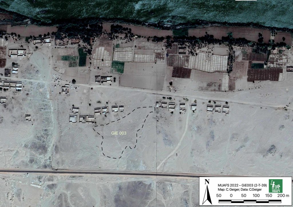
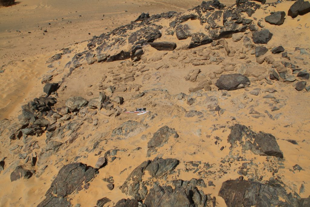
The Kerma cemetery, which Vila documented as 2-T-39, was labelled GiE 003 by the MUAFS project. It comprises an estimated 150 tombs in an area of c. 200 x 100m. The actual extent of the cemetery requires further investigation; in the northern part, the site partially overlaps with the Medieval habitation 2-T-43.
Estimated outline of cemetery GiE 003 (Map: C. Geiger, courtesy of the DiverseNile project).
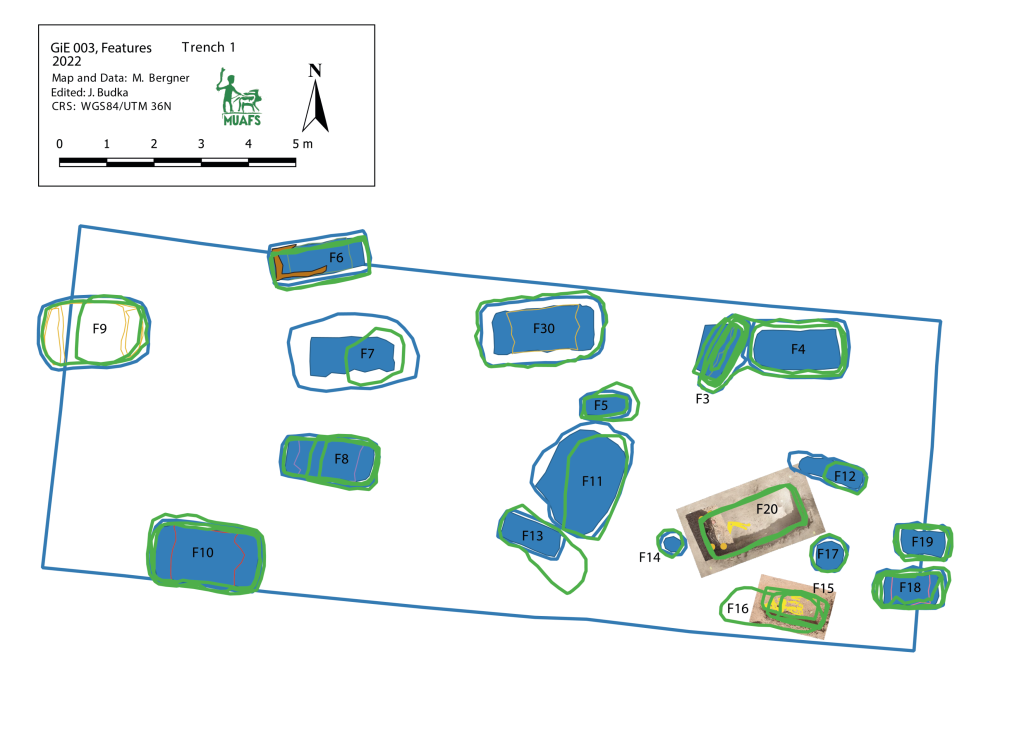
In March 2022, two trenches were opened in GiE 003 and are discussed in the EVO paper. Both trenches had eroded circular tumuli structures on their surfaces, which were covered with pottery sherds and human bones, clearly indicating ancient looting. Despite the age of the looting, some of the Kerma burials unearthed were well preserved and could be dated through the finds. The finds include fly pendants, a scarab with the name of a Hyksos king, a dagger, remains of funerary beds and plenty of beads as well as pottery.
A total of 27 pits were excavated in 2022. Through stratigraphic and pottery analysis it is also possible to make suggestions on the spatial and chronological development of the site. The EVO article is a preliminary assessment based on fieldwork results from 2022, including my detailed study of all the ceramics, but excluding bioarchaeological studies of human and animal bones, as well as the botanical remains.
The most important result of the 2022 excavation is the dating of the southern trench, Trench 2, to the Middle Kerma Period (c. 2000-1750 BCE) and of the northern trench, Trench 1, to the Classic Kerma Period (c. 1750-1500 BCE). This is especially significant, given that there were no notable differences in the surface structures.
In the EVO article, I proposed a possible relation of the Kerma community using GiE 003 to gold exploitation. First, in the MUAFS concession area, gold-rich quartz-veins have been found in Attab, Ginis, and Kosha, and some archaeological sites point to gold exploitation throughout the centuries, starting well before the Egyptian New Kingdom. Moreover, recent surveys in the Eastern Desert suggest that both control of gold mines and trade relationships with desert nomads played a major role in Kerman access to gold before Egyptian colonisation in the New Kingdom (see Cooper 2021). The affiliation of some of the pottery from GiE 003 with the Pan-Grave horizon seemed to illustrate in 2022 connections to nomadic people, possibly in relation to gold mining. This thesis could now be partly confirmed in 2023: in Trench 5 several Pan-Grave style burials were found (see my short summary of the 2023 season).
Here, I would like to follow Claudia Näser and her appeal for an “archaeology of interaction” (Näser 2012) – during the Kerma period, there were a number of Pan-Grave people present in the Nile Valley and for sure also in the Attab and Ginis area. They were community members (at least seasonally) interacting in various ways with other members – and our focus should be on understanding these interactions and reconstructing them as best we can. This is one of the core interests of the DiverseNile project and will keep us busy in the next years.
Our work in GiE 003 in the 2023 season resulted in many important new insights, supporting and strengthening ideas raised in the EVO article based on the 2022 season.
Coming back to cemetery GiE 003: one of the results of our excavation work is clearly that funerary practices reflecting social practices in the periphery of the Kerma kingdom must be considered in a more complex light than previously thought. Cultural diversity in the Middle Nile is well traceable during the Middle and Classic Kerma age in terms of architecture, location, burial types and grave goods. However, this requires further material assistance, with a focus on the social impact of cultural contact and the emerging patterns of globalisation during the Kerma kingdom’s heyday. The proximity of Kerma cemeteries (and thus also of possible settlements), especially also of dome grave assemblages well attested in the Attab to Ferka region, to potential gold working sites is clearly an interesting research question to be investigated in the future.
All in all, it seems likely that there was no single Kerman cultural input to interactions with the Hyksos, Egyptians and nomadic people like the Pan-Grave horizon. Rather, we must consider various hierarchical local responses determined by different communities’ ability to consume, shaping what can be called marginal communities in the Kerma state (see also Walsh 2022).
To concluse, the rich finds in GiE 003 enable us to compare this newly excavated Kerma cemetery to the well-known cemeteries of Ukma and Akasha further north. There are very close parallels, as well as notable differences and what appears to be local variations (for details see Budka 2022). This opens new avenues for future research on Kerma communities outside of the Third Cataract region, shifting the focus away from cultural and chronological classification and toward aspects of the social relationships among Middle Nile groups (and their neighbours).
References:
Budka 2022 = J. Budka, Investigating Nubian funerary practices of marginal communities: new evidence from a Kerma cemetery at Ginis, Egitto e Vicino Oriente 45, 2022, 37-62.
Cooper 2021 = J. Cooper, Between the Nile and the Red Sea: Medjay desert polities in the third to first millennium BCE. Old World: Journal of Ancient Africa and Eurasia 1 (1), 2021, 1-22.
Näser 2012 = C. Näser, Nomads at the Nile: towards an archaeology of interaction, in: H. Barnard and K. Duistermaat (eds), The history of the peoples of the Eastern Desert, Los Angeles: University of California 2012, 80-89.
Walsh 2022 = C. Walsh, Marginal Communities and Cooperative Strategies in the Kerma Pastoral State. Journal of Ancient Near Eastern History, 9/2, 2022, 195-220.
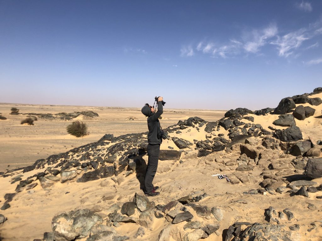
Our week 3 of the 2023 season was dominated by another drop in temperatures and very windy weather – there were only three days when we could work all day, on the other days too much sand in the air forced us to stop work early and continue with documentation and processing in the digging house.
Most importantly, our totalstation was fixed and is back to its normal daily routine. The wind prevented Kate to do much drone aerial photography, but thanks to the new Trimble Catalyst Antenna she was very busy documenting the landscape and many dry-stone walls in the area of Attab West and Ginis West.
While we were waiting for our totalstation, Chloe, Jose and I continued at the intriguing site 2-S-54, the 18th Dynasty building made of mud bricks and stones located on a steep slope of a rocky outcrop within the district of Foshu. A stunning view to work!
Chloe working at site 2-S-54.Photographing the dense mud brick collapse in the northern part of the structure. We also took 3D models of all surfaces exposed so far.
We exposed more of the surface around the structure and worked on the dense mud brick debris on its interior – more early 18th Dynasty ceramics, including Nubian style pots and also one hybrid cooking pot were unearthed – extremely exciting! A good number of large fragments of sandstone grindstones came to light and these were already documented by Sofia. This could already be a small hint that also this site is associated with goldmining. Modern gold working is carried out in large scale just next to us – in general a nice continuation illustrating the long-lasting impact of the natural resources for this part of the Middle Nile. However, since some of these modern pits and diggings also threaten the archaeological sites, I am rather concerned about this new development at Attab West.
Much progress was made exposing the 18th Dynasty structure at site 2-S-54.
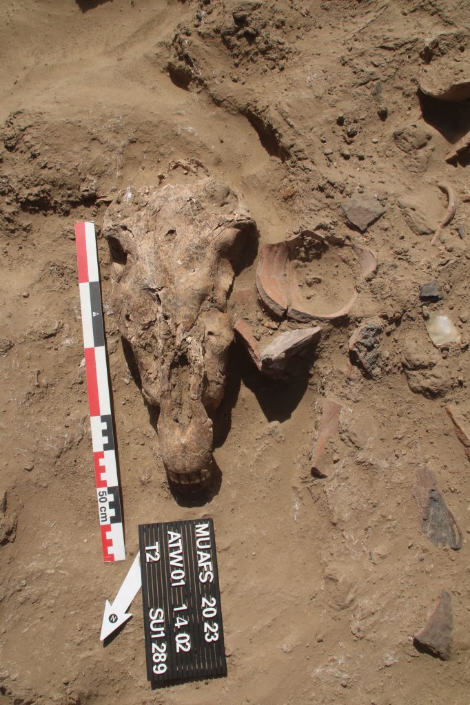
Work at 2-S-54 will continue in week 4, since we moved back to the domestic site AtW 001 with our gang of local workmen during week 3. Here, the dense mud brick debris revealed further complete pottery vessels as well as a very well preserved animal skull, most probably of a donkey.
Well-preserved animal skull in the mud brick debris layer at AtW 001. It was found at the bottom of a slight slope, sourrounded by brick debris and pottery fragments.
There are plenty of other animal jaws and bones in the collapse and it really seems as if most of this debris is partly rubbish. In addition, we have exposed more circular pits, presumably fire pits or storage structures.
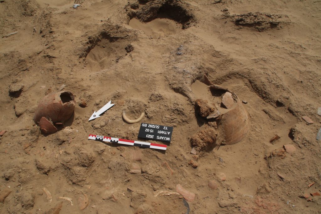
More complete pottery vessels were found in week 3 at ATW 001. Especially exciting is the complete zir in the pit on the right of the picture.
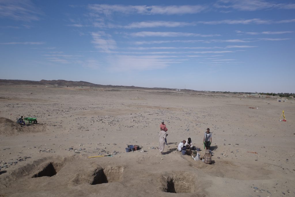
Since we have reached a level where the contexts are now quite delicate and also space for work is limited, we moved our team of local workmen to the East bank (this is the “better” bank regarding wind and was thus received with much enthusiasm by the workmen). Jose and Huda started yesterday at the Kerma cemetery GiE 003 with two new trenches, aiming for a better understanding of the distribution patterns of burials at the site. Chloe and Sofia were busy setting up the new fix points and conducting measurements with the totalstation. The first burial pits are already visible in the new Trench 3 and I am sure I will be able to report interesting finds on the next update coming Friday.
It’s a great pleasure to introduce our new team member of the ERC DiverseNile project: Maria Sofia Patrevita joined us this week as a new PhD student.
Sofia Patrevita earned her MA degree in Ethiopian archaeology at the University of Naples “L’Orientale”, specialized in goldsmithing and metalworking in ancient Ethiopia. Furthermore, she is herself a goldsmith apprentice – allow her to assess ancient gold working from a very specific and highly promising perspective.
I am very happy that Sofia is now strengthening our common interests in gold exploitation in ancient Sudan and more specifically in the Attab to Ferka region. In her PhD project with the working title „Ancient goldworking and goldsmithing in the Middle Nile region“ she will focus on questions related to styles, technologies, and experimental archaeology. She already has great experience in ethno-archaeology and experimental studies and will continue these lines of research with us in Munich. Her project is particularly well-timed because recent fieldwork is shedding new light on Nubia’s gold production and processing, stressing the active role of Nubian communities in the gold working business. Updates will follow here, stay tuned!
One of the first associations most archaeologists have with ancient Nubia is as a source of gold. Although it is well known that raw gold was extracted from various locations across Nubia (see Klemm & Klemm 2013), the previous focus of research was on Lower Nubia, the region between the Second and Third Cataract as well as the Eastern Desert (see most recently Davies & Welsby 2020).
Recent fieldwork in the Forth Cataract region is shedding new light on Nubia’s gold production and processing in regions previously considered as marginal. Of prime importance are the excavations at Hosh el-Guruf (Emberling & Williams 2010: 22; Williams 2020: 188).
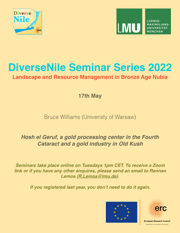
I am delighted that tomorrow’s DiverseNile Seminar will be focusing on “Hosh el Guruf, a gold processing centre on the Fourth Cataract and a gold industry in Old Kush”. Bruce Williams will present evidence from this important site which offers glimpses of early gold processing activities, among others numerous large grindstones associated with quartz crushing to extract gold.
One of the big questions about gold processing in Nubia is the origin of this grindstone technology (see Meyer 2010) – was it an innovation brought by the Egyptians or is it rather a local technique? Hosh el-Guruf has the potential to provide here answers and to illustrate the complexity of Nubian organisation of gold processing before the Egyptian colonisation (Williams 2020: 188).
I am very much looing forward to tomorrow’s lecture and highly recommend not to miss it!
References
Davies, W. Vivian & Derek A. Welsby (eds) 2020. Travelling the Korosko Road: archaeological exploration in Sudanʼs Eastern Desert. Sudan Archaeological Research Society Publication 24. Oxford: Archaeopress.
Emberling, G. & B. Williams. 2010. The Kingdom of Kush in the 4th Cataract: Archaeological Salvage of the Oriental Institute Nubian Expedition 2007 Season. Part I. Preliminary Report on the Sites of Hosh el-Guruf and El-Widay. Gdańsk Archaeological Museum and Heritage Protection Fund African Reports7: 17–38.
Klemm, R. & D. Klemm. 2013. Gold and Gold Mining in Ancient Egypt and Nubia. Geoarchaeology of the Ancient Gold Mining Sites in the Egyptian and Sudanese Eastern Deserts. New York: Springer.
Meyer, C. 2010. The Kingdom of Kush in the 4th Cataract: Archaeological Salvage of the Oriental Institute Nubian Expedition 2007 Season. Part II. Grinding Stones and Gold Mining at Hosh el Guruf, Sudan. Gdańsk Archaeological Museum and Heritage Protection Fund African Reports 7: 39–52.
Williams, B. 2020. Kush in the Wider World during the Kerma Period, in G. Emberling & B. Williams (eds) The Oxford Handbook of Ancient Nubia: 179–200. Oxford: Oxford University Press.
We have returned safely from Sudan and our short preparation season of the Munich University Attab to Ferka Survey Project (MUAFS) in its research concession between Attab and Ferka from Dec. 29 to January 9 was very successful.
Huda, our driver Saif and I getting ready to leave for another day of surveying the area (photo: C. Geiger).
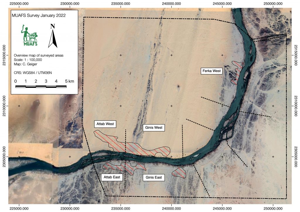
Huda and I conducted a foot survey in areas of Attab East, Attab West, Ginis East, Ginis West and Ferka West. The focus was on the identification of sites already recorded by Vila. We were able to document a total of 79 sites, comprising 21 new MUAFS sites. The sites range in date from Palaeolithic times to the Medieval and Ottoman eras. The types of sites are mostly camp sites, habitations, and tombs/cemeteries, but also include rock art and stone wadi walls.
Surveyed area of the 2021/2022 season (map: C. Geiger).
Whenever possible, we collected diagnostic pottery and lithics from the sites for dating purposes. I was able to document most of them by photography and also managed to draw 35 Kerma and New Kingdom sherds. Most interesting are some newly documented New Kingdom sites, attesting to both a use in the 18th Dynasty and a Ramesside presence in the periphery of Amara West.
One example of a newly documented site, unfortunatly recently plundered (photo: J. Budka).
One particularly striking site, a cluster of cleft tombs at Ginis East, has never been documented before but was unfortunately lately plundered. And this is not an isolated example! Recent plundering, modern gold working, new electricity lines and damaged caused by car tracks, roads and new buildings are unfortunately very frequent, have increased since 2020 and stress how urgently we need to document this rich area in the Middle Nile.
The surveying campaign carried out by Cajetan resulted in the setup of new benchmarks using a GPS Antenna and a totalstation in Attab East, Ginis East and Ginis West. We will use these benchmarks as basis for future measurements during our planned excavations. Drone aerial photography was successfully conducted in Ginis East, Ginis West and Ferka West.
All in all, I am very grateful to the support of our Sudanese friends and colleagues – without them our work at site would not have been possible in these very difficult times of political changes. We collected a large amount of new data and will now be very busy processing these here in Munich – and of course we will keep you updated.
We are very pleased to announce the DiverseNile Seminar Series for 2022. As a follow up of this year’s event, we will now focus on material culture and society in Bronze Age Nubia and respective perspectives from landscape and resource management.
It is my pleasure to open the Seminar Series on January 25 with an introduction and some ideas about global networks and local agents in the Middle Nile. Middle Nile contact space biographies we are currently reconstructing for the Attab to Ferka region provide a complex picture of a social space as a home to diverse groups and actors, rather than a static landscape and the periphery of centre-oriented narratives of New Kingdom Nubia. Our aim within the DiverseNile project is to decode, through our interdisciplinary studies, the economic role of the Attab to Ferka region for the principal centres, as a production area, and as land for animal husbandry and agriculture as well as for mining activities and gold production.
Rennan Lemos managed to gather a splendid group of speakers for the talks, covering a large set of topics from pottery technology to animal husbandry, gold extraction and much more.
We are looking much forward to this event and registration for the online DiverseNile Seminar Series 2022 is already open! Hoping to see many of you there – we will keep you updated about the specific schedule of the talks (always Tuesday, 1pm CET)!
Studying Kerma remains in the MUAFS concession area will provide fresh and urgently needed input for manifold, still open questions about a region far north of the Kerma capital, as our PI Julia Budka stated lately in her article about the Kerma presence in Ginis East (Budka 2020).
Today, I would like to give a short outlook over the settlements of the Kerma horizon in the Attab to Ferka region and exemplarily introducing you to an intriguing site, which seems to hold the potential for further thought (for Kerma tombs in Attab to Ferka see the blog entry of my colleague Rennan Lemos with his presentation of a fascinating Kerma burial).
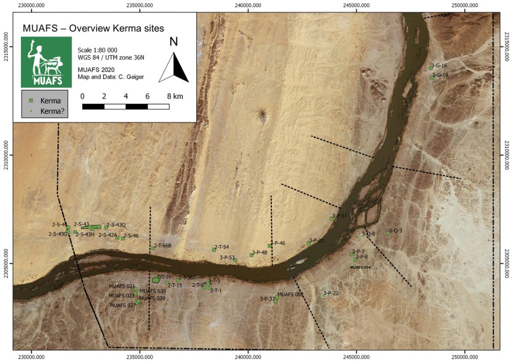
Currently, 30 settlements classified as Kerma are included in our database – whereby Egyptian New Kingdom presence at some of them and vice versa clearly illustrates the need to move away from the previous used interpretation of sites as rigid ‘Egyptian and ‘Nubian’ cultural units, addressing them as more closer interconnected cultures in this region (Budka 2020: 63).
Concerning their location, the settlements with Kerma presence are consistently distributed between both river banks with a certain dominance (18) on the right bank. Kerma sites on the left bank (12) were often situated in an impressive distance from the modern Nile, thus following the ancient course of the river. Besides a striking number of Kerma remains in the districts Attab and Ginis, Kerma sites can also be traced much further north (see Fig. 1).
Figure 1: Kerma sites in the region from Attab to Ferka (status 2020). Budka 2020: fig. 13 (modified).
These observations will not only shed further light on Sai during the Kerma period and its periphery, or the northern borders of the Kerma kingdom. Particularly important will be the insight how people lived there in the period of the New Kingdom occupation of Nubia – how the diverse social and cultural groups interacted with each other away from the major urban centres, collectively shaping, exploiting and making the landscape their home (Budka 2020: 63, Budka 2019: 24).
In a contact space like Attab to Ferka, it is the physical manifestations of the living that can shed light on how a cultural exchange could have happened, not only through the adoption or modification of ‘Egyptian’ patterns by the Nubians, but clearly vice versa – visible in the choice of design or used building material. Concerning the latter, with the fascinating site we will have a closer look now, I will focus today on dry-stone as building technique – a method Liszka states that “appears to have been passed down through generations of Nubians for many millennia” (Liszka 2017: 41).
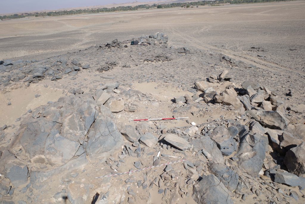
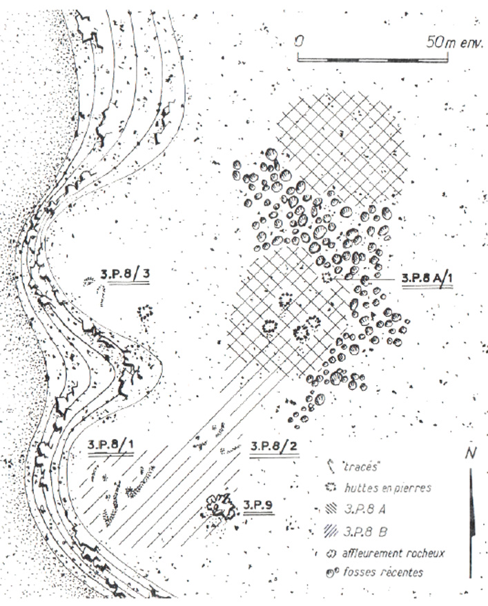
Besides the material the second characteristic of this site, detected by Vila and his team at Mindiq and numbered as NF-36-M/3-P-8 is its location further in the north of the MUAFS concession (Vila 1976: 90–96). More precisely the archaeological remains were found in the north-eastern part of Kosha East, situated in an impressive distance of 750 m to the modern Nile on the first hills rising 10 to 12m above the Kosha plain. The site occupied an overall surface of 200 x 60m (NE-SW), with intermediate sterile zones.Within this area, the areal NF-36-M/3-P-8A/B is from special interest (Fig. 2), being categorised by Vila as habitation site – a term he specifically used for remains of organised structures, perhaps being once a permanent settlement.
Whereas Vila still proposed a Neolithic or Nubien Ancien/Moyen context of the site, his attribution could be revised by our PI during our last campaign, giving, besides the Neolithic, a presumptive Old or Middle Kerma date, based on a large number of Kerma pottery.
Looking closer at Vila’s description of the character and the nature of the site, the division in 3-P-8A and 3-P-8B is explained by the existence of stone structures together with sherds and stone tools in part 3-P-8A at the centre and in the northern part of the site, whereas 3-P-8B consisted of a massive amount of stone tools scattered all over the site, with a certain concentration in the southern part, where no sherds were found.
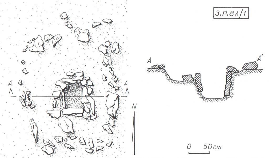
Figure 2: Mindiq, General sketch plan of site NF-36-M/3-P-8A/B (Kosha E). Vila 1976: fig. 41 (modified).
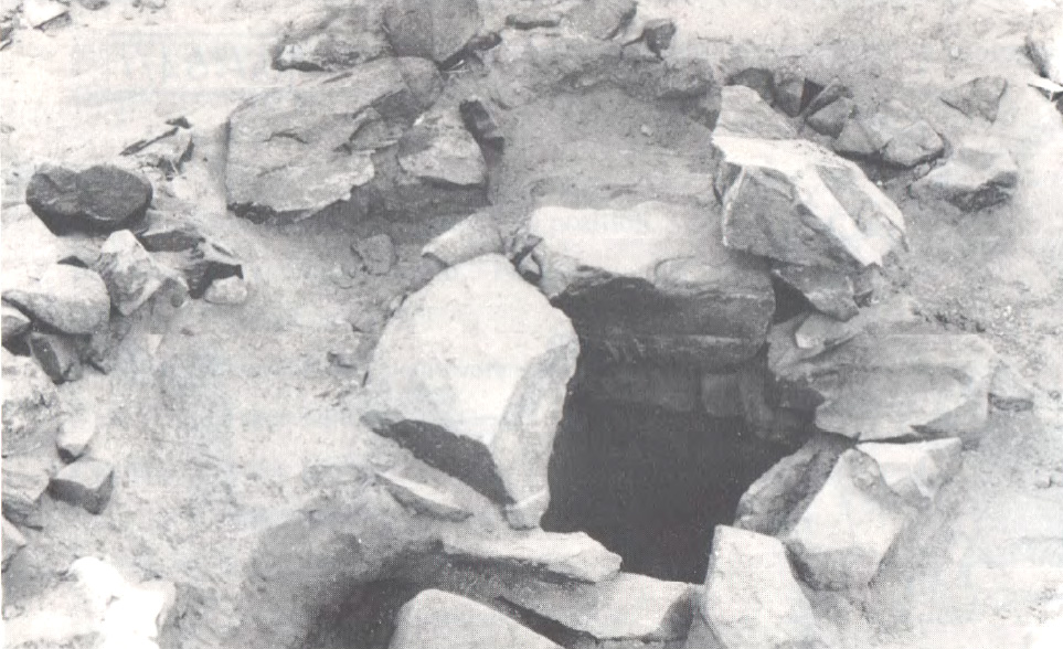
Concerning the questions of used material and building techniques the design of the stone remains in 3-P-8A are highly interesting – for a tentative interpretation of the site’s purpose also the nature of 3-P-8B can add some hints. In 3-P-8A Vila noted the remains of five dry stone huts – and in close proximity to them (originally connected?) – a feature from special interest (3-P-8A/1) (only) for which he gave a more detailed sketch plan and description: Its visible remains consisted of a quite circular structure made of stone blocks (possibly continuing with similar adjoining structures further north) with a diameter of approx. 4m. Within this stone structure the most interesting detail is a square stone-lined bin measuring approx. 60 cm x 60cm, with a depth of around 50/60cm, whose vertical walls were reinforced with raised slabs (Figs. 3a, b).
Figure 3a: Sketch plan and section of circular structure with stone-lined bin (NF-36-M/3-P-8A/1). (Vila 1976: fig. 42).Figure 3b: Detail of stone-lined bin in NF-36-M/3-P-8A/1, view towards S. (Vila 1976: fig. 44.1).
When visiting the place in the 1970ies, Vila and his team noted a heavily disturbed area in the northern part of the site, dividing 3-P-8A in two zones (Fig. 2), and consisting of pits of modern stone extractions. A similar picture emerged during our visit in the last campaign, when we found the site badly damaged by modern gold mining. These endangering activities not only clearly illustrate the urgent need of our research in the MUAFS concession, but also the richness of resources of this region, especially in this area, still being extracted today.
Thus, together with the abundance of stone tools indicated by Vila in 3-P-8A/B – further attested by the numerous quartz flakes we found on site – may point to an original purpose of the site associated with gold processing activities. In this context, one may wonder what role the above mentioned stone-lined bin might have played and if the architectural nature of the site 3-P-8/A with its dry-stone constructions could strengthen this assumption? Looking outside the box – thus beyond the MUAFS research area to other comparable frontier and contact spaces of similar time periods within Nubia may help to gain more thought-provoking hints.
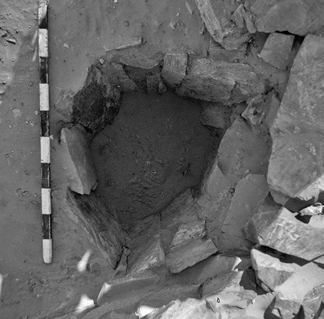
Here I will just refer to the evidence in the Batn el-Hagar, recently published by Edwards who introduced the occurrence of a fascinating category of Pharaonic sites, that clearly outnumbered other types of settlements in this region. Besides their number, their peculiarity consists especially of their dry-stone architecture and their often curvilinear layout – representing as Edwards stated “a still unfamiliar form of an ‘Egyptian’ presence” in Nubia (Edwards 2020: 378). These sites were apparently linked to gold mining activities within the region, which is why Edwards refers to them as ‘workshop sites’. Mostly situated in larger distances to the Nile their architecture consists of a number or dry-stone walls forming complexes of subcircular or curvilinear rooms. The different equipment found in these rooms points to different working units and working steps, as illustrated by large granite mortars and grinding installations of diverse types – but it is especially indicated by numerous stone-lined bins or tanks (Fig. 4) comparable to “our” example from Mindiq. Some of the latter seemed to be originally associated withworking processes using water and still contained accumulations of fine water-laid crushed gold bearing quartz (Edwards 2020: 404).
Figure 4: Example of a stone-lined bin (diam: 55 cm, depth: 45 cm, workshop site 11-Q-61, Saras E). Edwards 2020: fig. 3.3.31.
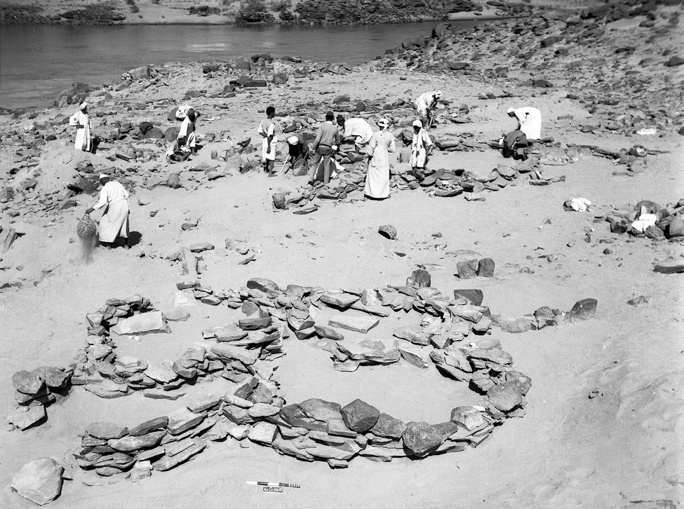
Concerning the rather unusual ‘Egyptian’ architectural appearance of those workshop sites, Edwards suggested a possible more complex history of Egyptian gold mining in this region – and a very plausible stronger role of Nubians in this context. His assumption was not only based on often found Nubian or Kerma style pottery within these workshops (f. ex. Duweishat area, workshop 16-O-12, Attiri – Sorki, with even a predominance of Nubian style ceramics, Edwards 2020: 226–234), but also on the existence of at least one similar site clearly dating in the Middle Kerma period (Duweishat area, workshop 16-S-16, also addressed as ‘Kerma/C-Group’ workshop site). The layout, finds and crushed quartz debris of his clearly Nubian site hold striking similarities to those qualified as Pharaonic workshop sites in this region (Edwards 2020: 406–407).
Figure 5: ‘Kerma/C-Group’ workshop site (16-S-16, Duweishat), 1967. Several large grindstones are visible at floor level of the nearest structure. Edwards 2020: Fig. 7.32.
Returning to our site in Kosha E, 3-P-8A/B, it would be tempting not only to assume a similar functional purpose, but – indicated by the today still visible remains – an original possibly related architectural layout. With clearly still needed further research in the coming years, this site with its presumed Old and Middle Kerma context already is from special interest due to its possible earlier date than the aforementioned site 16-S-16 in the Duweishat region. Thus site 3-P-8A/B, holds not only important hints about the gold-working activities in the Attab to Ferka area but also may help to shed further light on early Nubian gold exploitation.
Not least this early site has the potential to deeper explore the still pending ‘chicken or the egg-problem’ – so the question (is it) ‘Egyptian or Nubian?’ that Liszka chose concisely as title of her important article (Liszka 2017) on the matter of dry-stone architecture in Nubia in ‘Egyptian’ contexts. It is precisely such sites, that not only allow us to find answers concerning the activities of ancient people living there and the reasons for the choice of diverse building techniques, for different materials or locations (f. ex. being possible rather pragmatic choices depending on the better availability of stone or are they rather hinting to an internal cultural variability? Or point they to a rather seasonal occupation resp. are explained by the sites purpose?). But most importantly, architectural remains, such as these dry-stone buildings used by ‘Nubians’ or ‘Egyptians’ can also contribute to reconstruct the dynamics of such an ancient ‘contact space’ as the Attab and Ferka region – does it point, f. ex. to knowledge transfer throughout the times and cultures or to the inclusion of craftsmanship of well-trained people, thus not only resulting in acceptance or appropriation of various cultural influences, but also in possible fusions creating together something new.
In this regard – stay tuned for further insights in the fascinating topic of exploring the settlement-scape and the nature of living in the Attab to Ferka region!
References
Budka, J. 2019 (with contributions by G. D’Ercole, C. Geiger, V. Hinterhuber and M. Scheiblecker). Towards Middle Nile Biographies: the Munich University Attab to Ferka Survey Project 2018/2019, in: Sudan & Nubia 23, 13–26.
Budka, J. 2020. Kerma presence at Ginis East: The 2020 season of the Munich University Attab to Ferka Survey Project, in: Sudan & Nubia 24, 57–71.
Edwards, D.N (ed.). 2020. The Archaeological Survey of Sudanese Nubia, 1963–69. The Pharaonic Sites. Oxford.
Liszka, K. 2017. Egyptian or Nubian? Dry-Stone Architecture at Wadi el-Hudi, Wadi es-Sebua, and the Eastern Desert’, in: Journal of Egyptian Archaeology 103(1), 35–51.
Vila. A. 1976. La prospection archéologique de la vallée du Nil au sud de la Cataracte de Dal. Fascicule 4. District de Mograkka (Est et Ouest). District de Kosha (Est et Ouest).Paris.
