
Following up my last blog entry I would like to provide you an insight into the first archaeological prospection campaign almost two years ago, the work in the field and our challenges.
The first geophysical campaign in the Attab to Ferka region included magnetometry as well as magnetic susceptibility measurements. It took place during the first MUAFS season in December 2018/January 2019 and covered more than 6 ha at four different sites on the East bank of the Nile (GiE001 – GiE004). Our grid system for magnetic measurements consists of 40 x 40 m squares, which were staked out using a right-angle prism, measuring tapes and ranging poles. The advantage of staking out by hand is that we could perfectly orientate our grid system regarding the site and its visible traces as well as the topography. Excepting some quartz outcrops, burial mounds, dense bushes and deep wadis, staking out and walking with the magnetometer was feasible.
For every grid corner we were using wooden sticks to fix our marked base lines for the measurements. For taking magnetic measurements we used the Foerster Ferex 4.032 Gradiometer (65 cm Gradient) in handheld Quadro-sensor configuration. The grids are measured in zig-zag mode every 2 m to reach a spatial coverage of 0,5 x 0,125 m. It is important not to use ferromagnetic pieces for the instrument, that’s why the frame is completely non-magnetic. Furthermore, the measuring person as well as the helping people around are not wearing magnetic clothes/accessories.
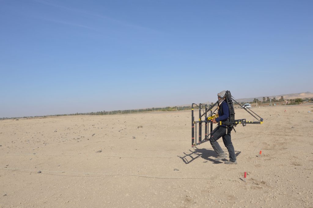
Not only the measuring equipment and person have to be non-magnetic, there shouldn’t be magnetic disturbances in the surrounding area as well, for example streets, train, powerlines etc. Their noise is affecting the measurements and at its worst making them impossible or useless. Our investigated sites were suitable for magnetic measurements; solely the pillars of the powerline were disturbing the measurements in the direct surrounding of the pillars at our first site.
But there were other challenges: strong winds during our campaign made it quite difficult to stake out the grids properly. That’s why it took longer as usual and influenced also the communication as you couldn’t understand each other standing 40 m apart. Additionally, it was quite tricky to walk straight, with the same speed and with a constant distance between the probes and the ground (ideally 30 cm). It was not only more time consuming but also taking more strength to do the measurements in that windy, squally surrounding and also to avoid vibrations of the bag-pack and the magnetometer frame, which would affect the measurements.
A crucial part of fieldwork though is the exact positioning of the investigated areas! As magnetometry is a passive method, you can repeat the measurements as often as needed. Using precise positioning you can come back to specific spots you are interested in. For example, excavation trenches can be specified easily avoiding time consuming and expensive large area trenches. Furthermore, archaeological survey results can be combined, at best including dating of architectural features. Altogether it is feasible to follow special issues and questions regarding the micro and macro region of sites.
To georeference our magnetic data we took the coordinates of every wooden stick marking the corners of the grids. Therefore, we were using our dGPS (Differential Global Positioning System). As no official benchmarks are available in the Attab to Ferka region new fixpoints were set. The advantage is that we can use them not only for surveys but also for integrating the excavation trenches into our GIS-projects.
Unfortunately, several of our benchmarks set in 2018/2019 and embedded in concrete were missing when coming back to the region for the excavation campaign in early 2020. That’s why a quick solution had to be found to use the created measurement grid further on, where not only the benchmarks and survey points were integrated, but also the data collected during drone mapping and magnetic survey. A fictive grid was set up based on the remaining benchmarks to embed the new excavation trenches and their photogrammetry data.
Our challenge now is to merge both datasets to be able to compare the excavated features with all collected magnetic data as well as our high-resolution drone images. This allows to verify the magnetometry results and learn more for new measurements in future.