
Studying Kerma remains in the MUAFS concession area will provide fresh and urgently needed input for manifold, still open questions about a region far north of the Kerma capital, as our PI Julia Budka stated lately in her article about the Kerma presence in Ginis East (Budka 2020).
Today, I would like to give a short outlook over the settlements of the Kerma horizon in the Attab to Ferka region and exemplarily introducing you to an intriguing site, which seems to hold the potential for further thought (for Kerma tombs in Attab to Ferka see the blog entry of my colleague Rennan Lemos with his presentation of a fascinating Kerma burial).
Currently, 30 settlements classified as Kerma are included in our database – whereby Egyptian New Kingdom presence at some of them and vice versa clearly illustrates the need to move away from the previous used interpretation of sites as rigid ‘Egyptian and ‘Nubian’ cultural units, addressing them as more closer interconnected cultures in this region (Budka 2020: 63).
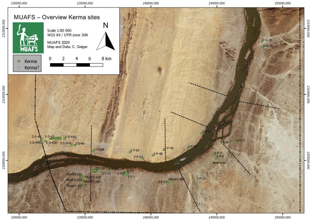
Concerning their location, the settlements with Kerma presence are consistently distributed between both river banks with a certain dominance (18) on the right bank. Kerma sites on the left bank (12) were often situated in an impressive distance from the modern Nile, thus following the ancient course of the river. Besides a striking number of Kerma remains in the districts Attab and Ginis, Kerma sites can also be traced much further north (see Fig. 1).
These observations will not only shed further light on Sai during the Kerma period and its periphery, or the northern borders of the Kerma kingdom. Particularly important will be the insight how people lived there in the period of the New Kingdom occupation of Nubia – how the diverse social and cultural groups interacted with each other away from the major urban centres, collectively shaping, exploiting and making the landscape their home (Budka 2020: 63, Budka 2019: 24).
In a contact space like Attab to Ferka, it is the physical manifestations of the living that can shed light on how a cultural exchange could have happened, not only through the adoption or modification of ‘Egyptian’ patterns by the Nubians, but clearly vice versa – visible in the choice of design or used building material. Concerning the latter, with the fascinating site we will have a closer look now, I will focus today on dry-stone as building technique – a method Liszka states that “appears to have been passed down through generations of Nubians for many millennia” (Liszka 2017: 41).
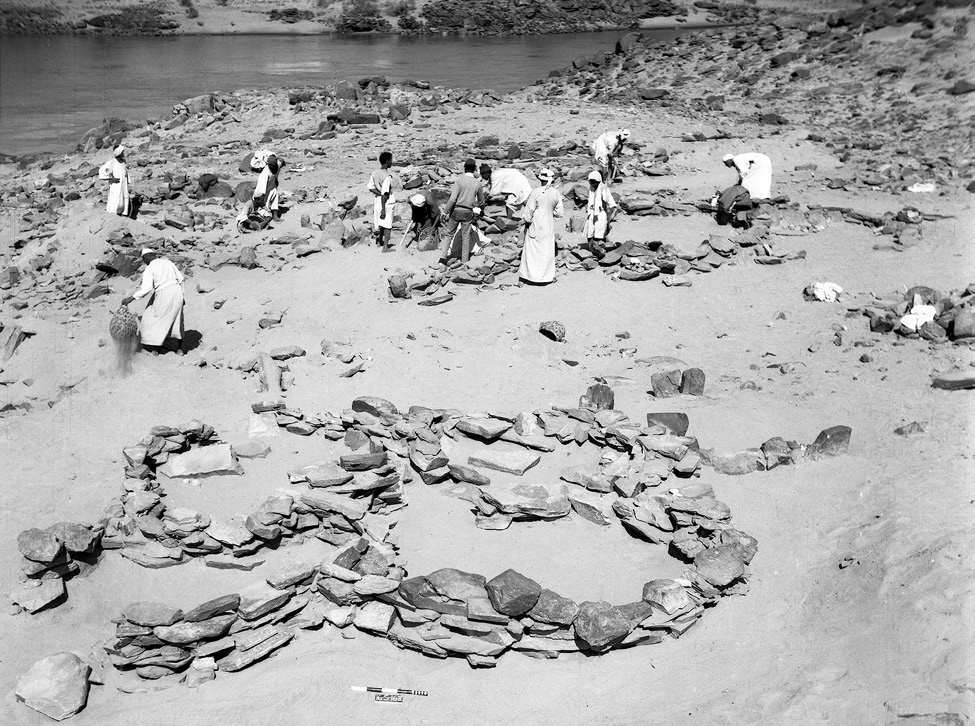
Besides the material the second characteristic of this site, detected by Vila and his team at Mindiq and numbered as NF-36-M/3-P-8 is its location further in the north of the MUAFS concession (Vila 1976: 90–96). More precisely the archaeological remains were found in the north-eastern part of Kosha East, situated in an impressive distance of 750 m to the modern Nile on the first hills rising 10 to 12m above the Kosha plain. The site occupied an overall surface of 200 x 60m (NE-SW), with intermediate sterile zones.Within this area, the areal NF-36-M/3-P-8A/B is from special interest (Fig. 2), being categorised by Vila as habitation site – a term he specifically used for remains of organised structures, perhaps being once a permanent settlement.
Whereas Vila still proposed a Neolithic or Nubien Ancien/Moyen context of the site, his attribution could be revised by our PI during our last campaign, giving, besides the Neolithic, a presumptive Old or Middle Kerma date, based on a large number of Kerma pottery.
Looking closer at Vila’s description of the character and the nature of the site, the division in 3-P-8A and 3-P-8B is explained by the existence of stone structures together with sherds and stone tools in part 3-P-8A at the centre and in the northern part of the site, whereas 3-P-8B consisted of a massive amount of stone tools scattered all over the site, with a certain concentration in the southern part, where no sherds were found.
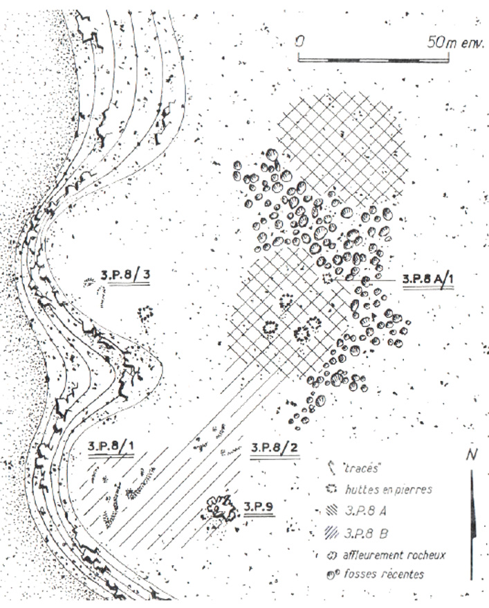
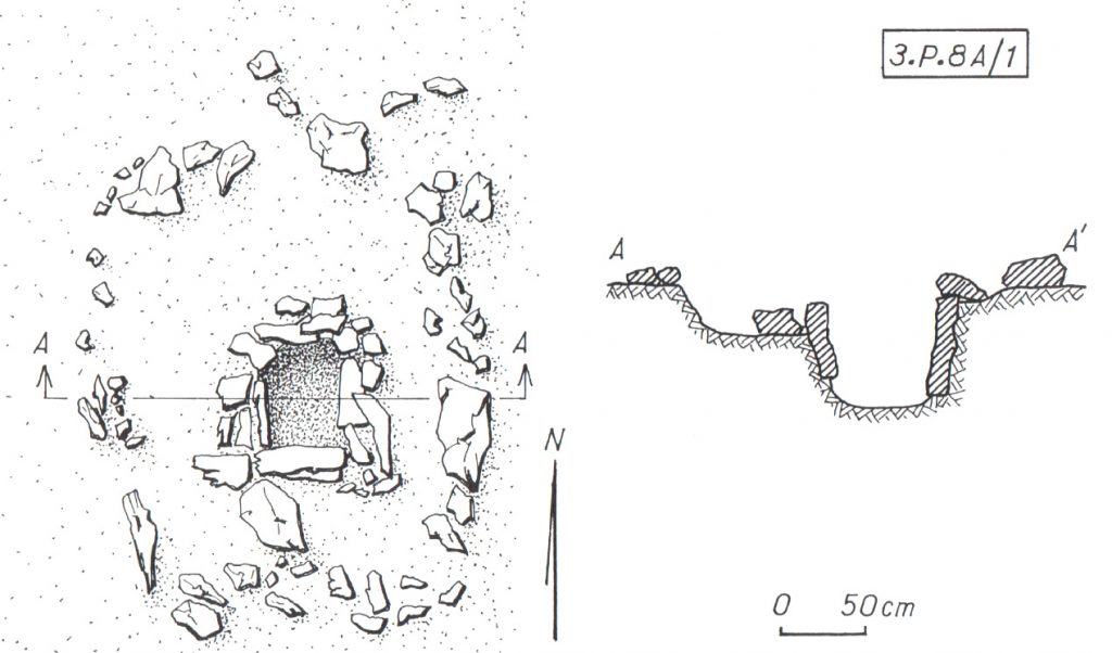
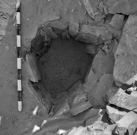
Concerning the questions of used material and building techniques the design of the stone remains in 3-P-8A are highly interesting – for a tentative interpretation of the site’s purpose also the nature of 3-P-8B can add some hints. In 3-P-8A Vila noted the remains of five dry stone huts – and in close proximity to them (originally connected?) – a feature from special interest (3-P-8A/1) (only) for which he gave a more detailed sketch plan and description: Its visible remains consisted of a quite circular structure made of stone blocks (possibly continuing with similar adjoining structures further north) with a diameter of approx. 4m. Within this stone structure the most interesting detail is a square stone-lined bin measuring approx. 60 cm x 60cm, with a depth of around 50/60cm, whose vertical walls were reinforced with raised slabs (Figs. 3a, b).
When visiting the place in the 1970ies, Vila and his team noted a heavily disturbed area in the northern part of the site, dividing 3-P-8A in two zones (Fig. 2), and consisting of pits of modern stone extractions. A similar picture emerged during our visit in the last campaign, when we found the site badly damaged by modern gold mining. These endangering activities not only clearly illustrate the urgent need of our research in the MUAFS concession, but also the richness of resources of this region, especially in this area, still being extracted today.
Thus, together with the abundance of stone tools indicated by Vila in 3-P-8A/B – further attested by the numerous quartz flakes we found on site – may point to an original purpose of the site associated with gold processing activities. In this context, one may wonder what role the above mentioned stone-lined bin might have played and if the architectural nature of the site 3-P-8/A with its dry-stone constructions could strengthen this assumption? Looking outside the box – thus beyond the MUAFS research area to other comparable frontier and contact spaces of similar time periods within Nubia may help to gain more thought-provoking hints.
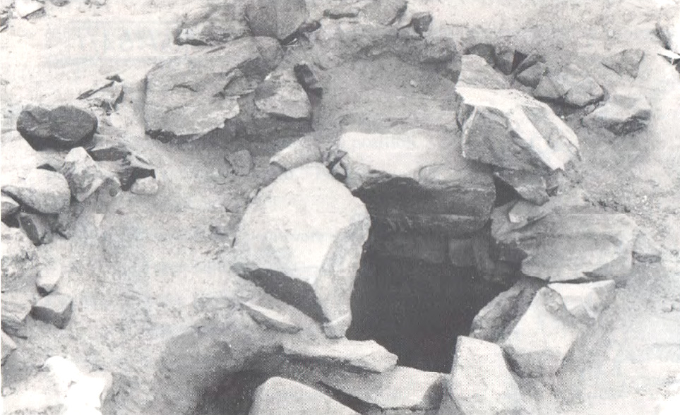
Here I will just refer to the evidence in the Batn el-Hagar, recently published by Edwards who introduced the occurrence of a fascinating category of Pharaonic sites, that clearly outnumbered other types of settlements in this region. Besides their number, their peculiarity consists especially of their dry-stone architecture and their often curvilinear layout – representing as Edwards stated “a still unfamiliar form of an ‘Egyptian’ presence” in Nubia (Edwards 2020: 378). These sites were apparently linked to gold mining activities within the region, which is why Edwards refers to them as ‘workshop sites’. Mostly situated in larger distances to the Nile their architecture consists of a number or dry-stone walls forming complexes of subcircular or curvilinear rooms. The different equipment found in these rooms points to different working units and working steps, as illustrated by large granite mortars and grinding installations of diverse types – but it is especially indicated by numerous stone-lined bins or tanks (Fig. 4) comparable to “our” example from Mindiq. Some of the latter seemed to be originally associated withworking processes using water and still contained accumulations of fine water-laid crushed gold bearing quartz (Edwards 2020: 404).
Concerning the rather unusual ‘Egyptian’ architectural appearance of those workshop sites, Edwards suggested a possible more complex history of Egyptian gold mining in this region – and a very plausible stronger role of Nubians in this context. His assumption was not only based on often found Nubian or Kerma style pottery within these workshops (f. ex. Duweishat area, workshop 16-O-12, Attiri – Sorki, with even a predominance of Nubian style ceramics, Edwards 2020: 226–234), but also on the existence of at least one similar site clearly dating in the Middle Kerma period (Duweishat area, workshop 16-S-16, also addressed as ‘Kerma/C-Group’ workshop site). The layout, finds and crushed quartz debris of his clearly Nubian site hold striking similarities to those qualified as Pharaonic workshop sites in this region (Edwards 2020: 406–407).
Returning to our site in Kosha E, 3-P-8A/B, it would be tempting not only to assume a similar functional purpose, but – indicated by the today still visible remains – an original possibly related architectural layout. With clearly still needed further research in the coming years, this site with its presumed Old and Middle Kerma context already is from special interest due to its possible earlier date than the aforementioned site 16-S-16 in the Duweishat region. Thus site 3-P-8A/B, holds not only important hints about the gold-working activities in the Attab to Ferka area but also may help to shed further light on early Nubian gold exploitation.
Not least this early site has the potential to deeper explore the still pending ‘chicken or the egg-problem’ – so the question (is it) ‘Egyptian or Nubian?’ that Liszka chose concisely as title of her important article (Liszka 2017) on the matter of dry-stone architecture in Nubia in ‘Egyptian’ contexts. It is precisely such sites, that not only allow us to find answers concerning the activities of ancient people living there and the reasons for the choice of diverse building techniques, for different materials or locations (f. ex. being possible rather pragmatic choices depending on the better availability of stone or are they rather hinting to an internal cultural variability? Or point they to a rather seasonal occupation resp. are explained by the sites purpose?). But most importantly, architectural remains, such as these dry-stone buildings used by ‘Nubians’ or ‘Egyptians’ can also contribute to reconstruct the dynamics of such an ancient ‘contact space’ as the Attab and Ferka region – does it point, f. ex. to knowledge transfer throughout the times and cultures or to the inclusion of craftsmanship of well-trained people, thus not only resulting in acceptance or appropriation of various cultural influences, but also in possible fusions creating together something new.
In this regard – stay tuned for further insights in the fascinating topic of exploring the settlement-scape and the nature of living in the Attab to Ferka region!
References
Budka, J. 2019 (with contributions by G. D’Ercole, C. Geiger, V. Hinterhuber and M. Scheiblecker). Towards Middle Nile Biographies: the Munich University Attab to Ferka Survey Project 2018/2019, in: Sudan & Nubia 23, 13–26.
Budka, J. 2020. Kerma presence at Ginis East: The 2020 season of the Munich University Attab to Ferka Survey Project, in: Sudan & Nubia 24, 57–71.
Edwards, D.N (ed.). 2020. The Archaeological Survey of Sudanese Nubia, 1963–69. The Pharaonic Sites. Oxford.
Liszka, K. 2017. Egyptian or Nubian? Dry-Stone Architecture at Wadi el-Hudi, Wadi es-Sebua, and the Eastern Desert’, in: Journal of Egyptian Archaeology 103(1), 35–51.
Vila. A. 1976. La prospection archéologique de la vallée du Nil au sud de la Cataracte de Dal. Fascicule 4. District de Mograkka (Est et Ouest). District de Kosha (Est et Ouest).Paris.