This past season in Sudan, our drone program took flight (pun-intended) in more ways than one. We dedicated most of our efforts to flying programmed missions over large areas of the landscape mainly in Attab West, to collect data for the generation of Digital Elevation Models (DEMs) and orthophotos. In addition, we found time to make targeted flights of standing architecture for 3D modeling and visualization purposes. Digital recording of archaeological sites using the methods and principles of photogrammetry has immense implications for cultural heritage preservation.
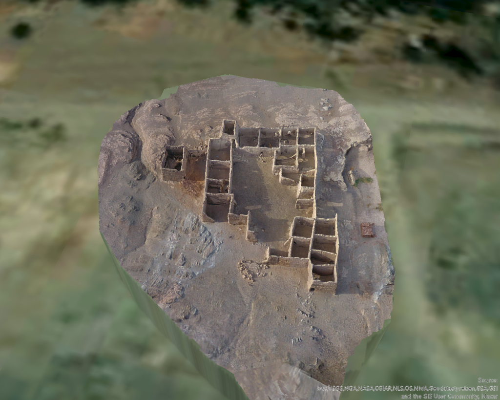
I was able to spend an entire day in Attab East documenting an extremely interesting, and remarkably well-preserved Islamic house, located just south of the Nile. The structure was identified and recorded by André Vila as site 2-S-57, a fortified Islamic house. It was built on a small raised rocky plateau, east of a small drainage channel.
Image of the Islamic house 3D model in Drone2Map, facing north.
The house is especially interesting in that many of its walls are still very well preserved, along with evidence of a second story, multiple small staircases, and a larger staircase in the northwestern corner of the house, leading to a tower-like structure. Several walls have also collapsed in recent years, and the collapsed building material remains in situ in the southeastern corner of the structure.
The house itself is designed with a large central courtyard surrounded by relatively small interior rooms. These rooms are all roughly rectangular in shape, seem to be similar sizes, and are mostly oriented east to west. Some rooms contain interior sub-divisions, as well as windows and doorways preserved along the northern exterior wall. The rooms form a cellular pattern around the central courtyard, a common architectural pattern in Islamic houses (Abu-Lughod 1987; Petruccioli 2008; Zolfagharkhani and Ostwald 2021). It would certainly be interesting to consider the use of domestic space in this house, as activity areas and movement patterns are surely present.
Current challenges exist to the house’s preservation, including erosion, flooding, and modern use of the house’s rooms as animal pens. It is interesting that there is continuity in the use of this structure for subsistence activities. However, it is extremely important to have the opportunity to digitally document well-preserved, at-risk sites such as this one. I collected approximately 700 images using our Phantom 4 drone of the site and processed a 3D model in Drone2Map.
Given the high-quality model, the site can be virtually “visited” on open-access sites like Sketchfab. This gives diverse publics the opportunity to engage with and experience the site. Furthermore, systematic analyses such as space syntax can be conducted to further understand the use of the site with the data from the model. Digital representations of archaeological sites are especially valuable during periods of political turmoil when cultural heritage may come under threat. Given the on-going conflict and humanitarian crisis in Sudan, and the enduring impact of the Covid 19 pandemic on research disciplines in general, archaeologists must continue to develop innovative solutions to critical problems of cultural heritage management and preservation.
Check out the model of the Islamic house for yourself on MUAFS’s Sketchfab profile:
Here you can play with the model, manipulate the view, zoom in on rooms and features, and experiment with the size of the model. Sketchfab is a completely free educational platform for all users. Be on the lookout for more models from the project in the future!
References:
Abu-Lughod, J.L. (1987). “The Islamic City–Historic Myth, Islamic essence, and Contemporary Relevance”, International Journal of Middle East Studies, 19(2), pp. 155-176.
Petruccioli, A. (2008). “House and Fabric in the Islamic Mediterranean City” in S.K. Jayyusi, R. Holod, A. Petruccioli, and A. Raymond (eds.), The City in the Islamic World: Volume 1. Leiden: Brill: pp. 851-876.
Zolfagharkhani, M. and Ostwald, M.J. (2021). “The Spatial Structure of Yazd Courtyard Houses: A Space Syntax Analysis of the Topological Characteristics of the Courtyard”, Buildings, 11(262), pp. 1-22.
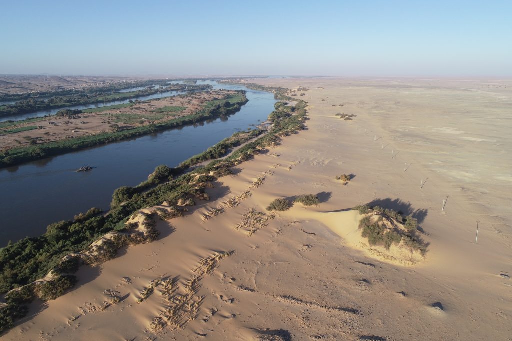
As a “landscape” archaeologist, I often have to ask myself, “What do I actually mean when I talk about landscapes?” This is far from a simple exercise, as landscapes seem to defy singular definition. Landscapes are also inherently multidimensional and interact with multi-layered social phenomena and processes such as economy, subsistence, religion, ritual, and political organization. I define landscape as the integration of natural surroundings with cultural phenomena which constitute and are constituted by social relationships. Landscapes are continuously reinvigorated and transformed by the experiences and identities of humans operating within them, and the interactions between humans, animals, ecosystems, climate, and topography. As I delve further into analysis of the landscapes of the Munich University Attab to Ferka Survey region, I try to revisit these central questions; what are landscapes and how can we best approach them from an archaeological and theoretical toolkit?
Drone photo taken in February 2023 by K. Rose showing the landscape near the Nile, from Attab West.
Landscape archaeology tackles the nuances of culture, environment, memory, meaning, and place-making. Landscape perspectives have evolved to recognize the permeability and relativity of landscapes, in that societies imbue their own sense of place and time on spaces (Anschuetz et al. 2001). This is a realization that extends beyond archaeology, as works from the realms of architecture, design, environmental studies, geography, history, psychology, and others reiterate the same principles. As the architect Amos Rapoport writes, “People seem to shape and interact with built environments/material culture primarily through meaning and this seems to hold over time, cross-culturally, and in all kinds of environments, contexts, and situations” (1990: 42). Anschuetz et al. (2001) argue for the adoption of a unified landscape perspective, which accounts for the theoretical and methodological development of the field and builds an epistemology of landscapes. The authors claim, “a landscape approach complements traditional archaeological space and time systematics through its processual and scientific means of analysis while at the same time integrating human history and agency into their constructions” (187). This perspective unites the main concerns and objectives of the two most dominant theoretical schools within the discipline of archaeology, Processualism (New Archaeology) and Post-processualism.
As someone who also is particularly interested in cemeteries, I often think about the intersections between landscapes and death. Neither death, nor landscapes were static components of ancient life. Cemeteries can be reconceptualized within archaeology as “mortuary landscapes.” Mortuary landscapes are not isolated phenomena; monuments of death scattered throughout the landscape. They, in concert with the natural landscape, are physically and ideologically transformative embodiments of long term social and cultural processes. Many works have explored this reconceptualization of cemeteries as inextricable from their natural and cultural surroundings (for examples pertaining to North Africa, see Stone and Stirling 2007 and Richards 1999, 2005). My working definition of mortuary landscapes is that they are built landscapes of burial, consisting of tombs, temples, and other constructions dedicated to death, strategically integrated with natural surroundings. These landscapes are complex, hubs of activity that develop and change over time due to natural and cultural processes. We must consider mortuary landscapes as active and dynamic spaces for the maintenance of identities of the dead and living.
Many past studies since the mid-20th century have situated a discussion of landscape archaeology within the context of the culture, history, geography, and environment of ancient Nubia and modern-day Sudan (Ahmed 1984; Caneva 1988; Edwards 1989; Garcea and Sebastiani 1998; Grzymski 2004; Hinkel 1994; Trigger 1965, 1982; Welsby 1998; Williams 1985). With respect to cemeteries, landscapes have also been integrated into studies from Neolithic to post-Medieval Nubia (Bashir 2021; Costanzo et al 2021; Emberling 2012; Weschenfelder 2015). There is a need for more studies that evaluate diachronic relationships between mortuary practices and landscapes using systematic, spatial methodologies. I intend to delve further into the application of systematic and spatial methodologies to Nubian contexts in a future blog post.
A framework that I think is helpful in achieving this mortuary landscape approach is “inscribing” the landscape. Inscription as a concept and a process has been discussed within the field of archaeology broadly. For example, in David and Wilson’s edited volume, Inscribed Landscapes: Marking and Making Place, landscape inscription is presented as a two-fold process: 1) the physical marking of the natural environment through monument construction such as rock art, and 2) and the social engagement of people with their environment that embodies landscapes with memories and “anchors people in place” (2002: 6). In studies of Nubia, the process of inscribing is discussed with reference to identity formation (Buzon et al 2016: 285) as well as landscape formation (Ambridge 2007). While there are many ways to describe this concept, I want to emphasize landscape inscription as a continuous process of imprinting and reproducing social meaning and relationships onto the physical environment through interactions and alterations that create a material signature. This includes the construction of architecture, and the use and manipulation of natural resources and features in creating patterns. Inscribing the landscape is akin to creating a dialogue between material culture and natural surroundings to translate the immaterial aspects of social relationships and phenomena. The landscape is the canvas on which the images of social meaning are drawn. This does not imply that social meaning can only be viewed or understood in one way. Interpretations will differ according to the perspectives, objectives, and biases of the inscribers and the viewers. Landscape inscription does not have an end point, so long as humans are interacting with their surroundings.
As archaeology for decades has attempted to reconcile structure and agency within the past, I conceive of landscapes as both agents and products of actions, processes, and changes. Furthermore, considering the process of death and veneration of the dead adds an interesting dimension to the landscape equation. In many cultures, such as the ones under investigation by the DiverseNile Project, death is obviously not viewed as an end result or product of a life. It is the continuation, an open door to another stage of being, an unfinished sentence. Landscapes, to me, exist in a similar plane, always in a process of becoming, never serving as a conclusion.
Ultimately, we hope that through a social biography approach to landscape (Budka 2020: 57; Kolen and Renes 2015) that delves into the interconnectedness of people, environment, material culture, and all organisms we can elucidate further patterns in landscape use and management over time; and identify more trajectories of continuity and change the inscribed landscapes of the Attab to Ferka region.
References:
Ahmed, K. A. (1984) Meroitic Settlement in the Central Sudan: An analysis of Sites in the Nile Valley and the Western Butana. Oxford: British Archaeological Reports, International Series 197.
Ambridge, L. (2007) ‘Inscribing the Napatan Landscape: Architecture and Royal Identity’ in N. Yoffee (ed.), Negotiating the Past in the Past: Identity, Memory, and Landscape in Archaeological Research. Tucson: The University of Arizona Press, pp. 128-154.
Anschuetz, K.F., Wilshusen, R.H. and Scheick, C.L. (2001) ‘An Archaeology of Landscapes: Perspectives and Directions,’ Journal of Archaeological Research, 9(2), pp.157-211.
Bashir, M.A.S. (2021) ‘Medieval and Post-Medieval Archaeology in the Sudan: A Study of Two Cemeteries at Mura, Northern State,’ The Algerian Journal of Humanities, 3(1), pp. 178-201.
Budka, J. (2020) ‘Kerma Presence at Ginis East: The 2020 Season of the Munich University Attab to Ferka Survey Project,’ Sudan & Nubia, 24, pp.57-71.
Caneva, I. (1988) El Geili: The History of a Middle Nile Environment, 7000 B.C.–A.D. 1500. Oxford: British Archaeological Reports, International Series 424.
Costanzo, S., Brandolini, F., Idriss Ahmed, H., Zerboni, A. and Manzo, A. (2021) ‘Creating the Funerary Landscape of Eastern Sudan,’ PLoS ONE, 16(7), pp. e0253511–e0253511.
David, B. and M. Wilson (eds.) (2002) Inscribed Landscapes: Marking and Making Place. Honolulu: University of Hawai’i Press.
Edwards, D. (1989) Archaeology and Settlement in Upper Nubia in the 1st Millennium A.D. Oxford: British Archaeological Reports, International Series 537.
Emberling, G. (2012) ‘Archaeological Salvage in the Fourth Cataract, Northern Sudan (1991 2008)’ in M. Fisher, P. Lacovara, S. D’Auria, and S. Ikram (eds.), Ancient Nubia: African Kingdoms on the Nile. Cairo: American University in Cairo Press: pp. 71-77.
Garcea, E. and R. Sebastiani (1998) ‘Advantages and Limitations of Surveys: The Case of the Napatan Region,’ Archéologie du Nil Moyen, 8, pp. 55-83.
Grzymski, K., (2004) ‘Landscape Archaeology of Nubia and Central Sudan.’ African Archaeological Review, 21(1), pp.7-30.
Hinkel, M. (1994) ‘The Water Reservoirs in Ancient Sudan’ in C. Bonnet (ed.), Etudes nubiennes. Conférence de Genève. Actes du VIIe Congrès International d’études nubiennes. Volume II. Genève: Mission Archéologique de l’Université de Genève au Soudan, pp. 171-175.
Kolen, J. and J. Renes (2015) ‘Landscape Biographies: Key Issues’, in J. Kolen, J. Renes and R. Hermans (eds.), Landscape Biographies: Geographical, Historical and Archaeological Perspectives on the Production and Transmission of Landscapes. Amsterdam: Amsterdam University Press, pp. 21-47.
Rapoport, A. (1990) History and Precedent in American Design. New York: Plenum Press.
Richards, J. (1999) ‘Conceptual landscapes in the Egyptian Nile valley’ in Ashmore, W. and B. Knapp (eds.), Archaeologies of Landscape: Contemporary Perspectives. Cambridge: Cambridge University Press, pp. 83-100.
Richards, J. (2005) Society and Death in Ancient Egypt: Mortuary Landscapes of the Middle Kingdom. Cambridge: Cambridge University Press.
Trigger, B. G. (1965) History and Settlement in Lower Nubia. New Haven: Yale University, Department of Anthropology (Yale University Publications in Anthropology 69).
Trigger, B. G. (1982) ‘Reisner to Adams: Paradigms of Nubian cultural history’ in J.M. Plumley (ed.), Nubian Studies. Warminster, pp. 223–226.
Welsby, D. (1998) ‘Roman Military Installations Along the Nile South of the First Cataract,’ Archeologie du Nil Moyen, 8, pp. 157–182.
Weschenfelder, J. (2015) ‘The Terminal Neolithic Cemetery in the Funerary Landscape of MOG034, Mograt Island, Sudan,’ Der Antike Sudan. Mitteilungen der Sudanarchäologischen Gesellschaft zu Berlin, 26, pp.145-152.
Williams, B. (1985) ‘A Chronology of Meroitic Occupation Below the Fourth Cataract,’ Journal of the American Research Center in Egypt, 22, pp. 149–195.
Digital technologies continue to inundate archaeology as a means of bridging scientific and humanistic approaches. More than merely an exercise in playing with flashy machines and fancy toys, 3D printing has wide-ranging implications for fostering education and outreach, the accessibility of archaeological heritage, and explorations in experimental archaeology.
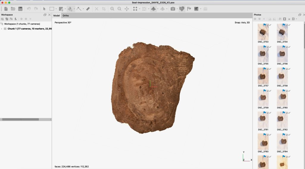
In my first month as a postdoc with the DiverseNile project, I began looking into different strategies and methodologies for making 3D models and prints of small objects. First up, we looked into printing a seal impression from the AcrossBorders project’s excavations at Sai Island. This mid-18th dynasty mud seal impression bears the name of Nehi and the title “Overseer of the Gateway” and is intact apart from a finger smudge in the lower left corner.
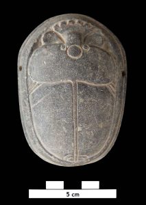
We also decided to experiment with printing an inscribed stone heart scarab also from the AcrossBorders project at Sai Island (figure 1). This object was excavated from the 18th dynasty burial of Khnum-mes and is inscribed on the bottom with Chapter 30 from the Book of the Dead (Budka 2021). Check out a blog post from 2017 about this find here.
Figure 1: The large stone heart scarab from the burial of Khnum-mes
To create models, we use photogrammetric methods to align photos of the object in Agisoft’s Metashape to create a textured mesh (figure 2). The photos of this object were taken during a study season in Khartoum in 2017 by Cajetan Geiger.
Figure 2: The 3D model of the seal impression in the Metashape interface
For this project, we needed a printed object quickly for a television appearance (keep reading to find out more!) so I looked into commercial printing options. I came across Xometry, a Germany-based company offering on-demand manufacturing of industrial parts. I like to think that they were both confused and delighted when they saw the small, inscribed objects on their platform!
Pros of this service: Xometry has a well-designed, functional, and easy to use website. With their instant quoting engine, you can upload 3D models (.stl, .obj, and many other formats) and immediately receive a cost and shopping estimate. Also, if there are issues with your model the engine will detect them. You can also choose the specific color, material, weight, and finish of your print.
Cons: While the website has extensive options for types of printing materials, most of the options are obviously very light-weight industrial plastics, polycarbonates, silica glasses, and nylons. If you are aiming for realism in your 3D print, you will not come across colors or materials on this site that can replicate those of many archaeological objects. Also, it should be noted that for this company, the minimum order is €50. If you just want one or two prototypes of small objects, you will have to order A LOT of copies just to come close to this high of a minimum!
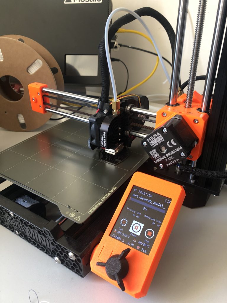
Given the drawbacks of working with large 3D printing companies like Xometry, I began to look into the possibility of collaborating with institutes on campus that may offer printers. After a bit of digging, I contacted the Medieninformatik Lab at LMU. Luckily, they have, not one, not two, but three (!) high quality, professional 3D printers; a Prusa Mini+ (PLA-3D printer), a Prusa i3 MK3S+ (PLA-3D printer), and the pièce de resistance, a Formlabs Form 3 (SLA-3D printer). The Prusa Mini+ and Prusa i3 models are some of the most ubiquitous printers (figure 3). They are extrusion-based printers which operate by heating a plastic material through a tube (filament) and distributing the heated material on a platform layer by layer, until it takes the full form of the object. The material is Polylactic acid (PLA) and can be heated at a low temperature. It is a robust, low-cost, and biodegradable material. Xometry prints using this method.
Figure 3: The Prusa Mini+ in action printing the heart scarab.
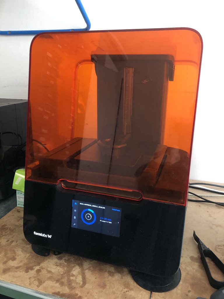
The Formlabs 3 printer operates with an entirely different method (figure 4). It uses stereolithography (SLA), which is a type of additive manufactory technology employing resin 3D printing. A light source like a laser or projector heats and cures liquid resin at a high temperature into hardened plastic in the shape of a 3D model. SLA printers have the ability to capture the highest resolution and most accurate details of objects, along with smoother surfaces and more complex geometries (size and shape of the print).
Figure 4: The Formlabs 3 printer preparing to cure resin for the print in the large orange vat.
Preliminary Results Printing with Xometry and the Medieninformatik Lab:
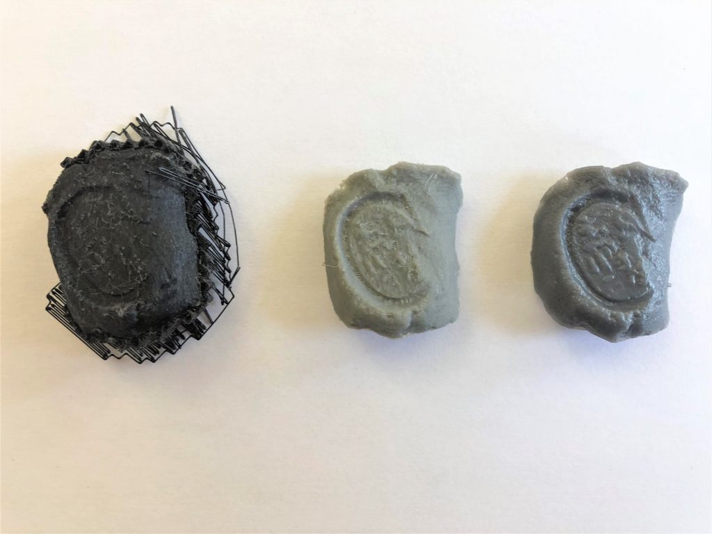
As apparent in figure 5, three different printing methods yielded three vastly different results. On the far left of the image is a print of the seal impression using a Prusa Mini+. As is evident, the fine details of the inscription of Nehi were too high resolution for the printer to capture with accuracy. The inscription is not legible and overall, the surface and geometry of the object are not clean. The middle print is of the seal impression from Xometry. Even though Xometry used a PLA printer (like the Prusa) the print is of a higher resolution, and the geometry of the object is more accurate. The surface is smoother and the inscription, while not perfect, is legible. Lastly, the far-right print is from the Formlabs 3 printer. This by far, is the highest quality and highest resolution print! The inscription is very legible, and the geometry of the object is extremely accurate. The surface is also smooth, extremely detailed, and shows no signs of lumps or imperfections in the raw material. While the Formlabs 3 printer is a more time-intensive and expensive process, the cured resin clearly is the superior material to capture intricate and complex details of smaller objects (figure 6).
Figure 5: Three prints of the seal impression from left to right: Prusa Mini+, Xometry print, and the Formlabs 3 print.Figure 6: Detail of the Formlabs 3 print
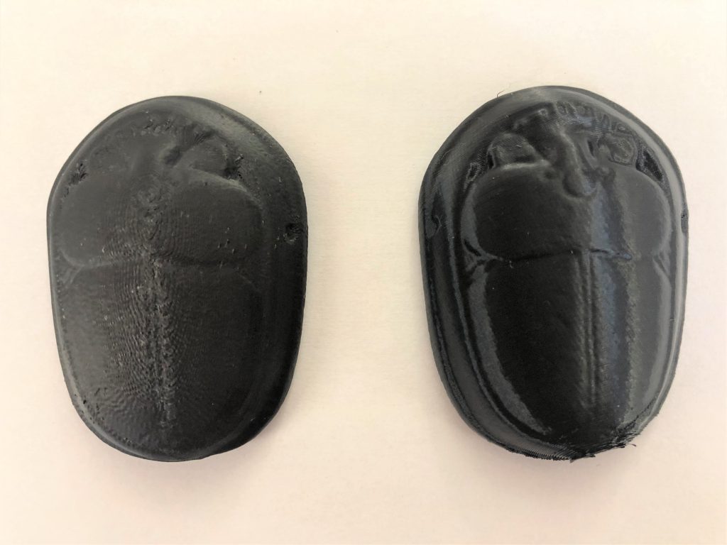
In terms of the heart scarab, the differences between prints are less stark but still significant. As evident in figure 7, the Xometry print (on the left) and the Prusa Mini+ print (on the right) are similar in shape and detail. The Prusa print has a smoother and cleaner surface, and slightly more legible details near the top of the scarab.
Figure 7: The Xometry print of the heart scarab (top) on the left and the Prusa Mini+ print on the right.Figure 8: The Xometry print of the heart scarab (bottom) on the left and the Prusa Mini+ print on the right.
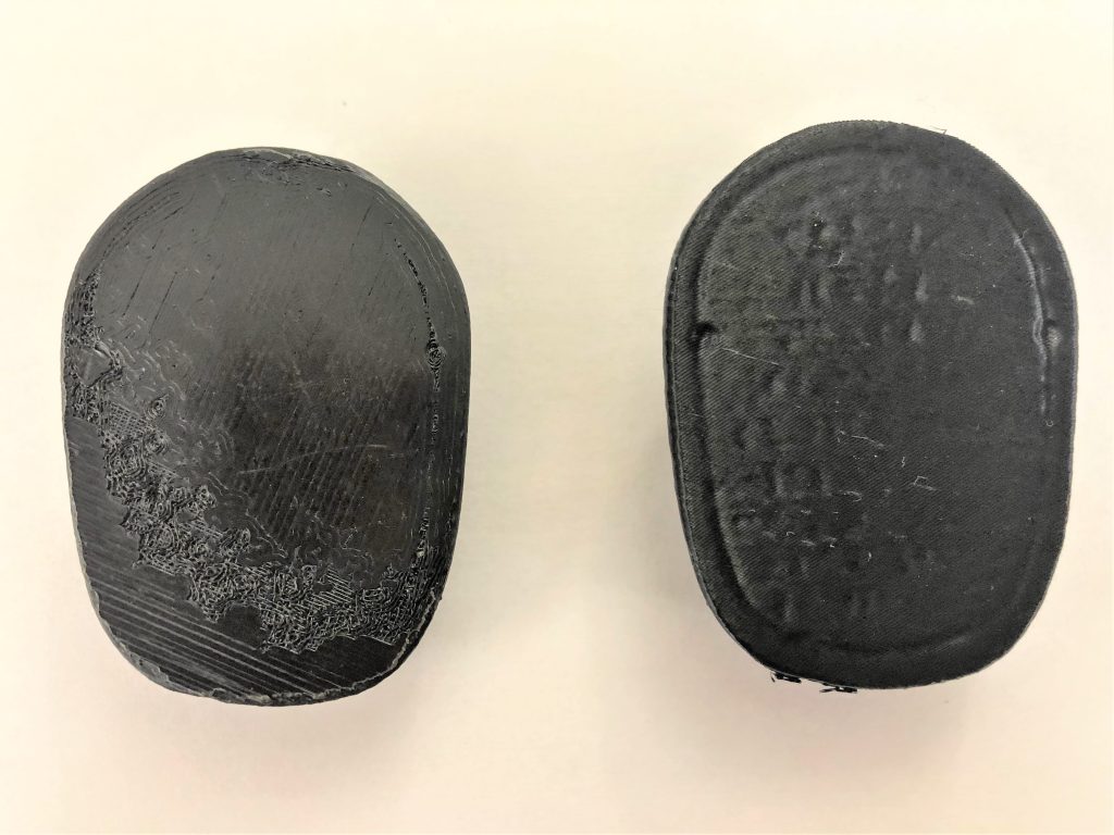
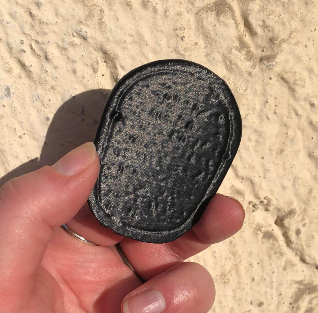
The bottom of the scarab demonstrates the biggest difference between the two prints (figure 8). The inscription was not captured at all on the Xometry print (left), due to the direction in which the print was oriented. If the print is rendered layer by layer with the bottom of the object flat on the printing platform, then any detail on the bottom of the object will not be captured. However, with the Prusa Mini+ print (right) the object was printed at an angle, and the result is a legible inscription (figure 9).
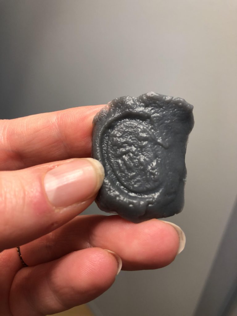
Figure 9: A detailed image of the inscription on the heart scarab in natural light
From these preliminary printing exercises, it was fascinating to see just how different prints of the same object can turn out given the variety of available printers, raw materials, and approaches. Clearly the various methods explored here have their pros and cons. 3D printing methods must be tailored to the specific goals of the project and qualities of the object/3D model. Trial and error, if you have the available resources and time, is a terrific way to start!
The Significance and Broader Impact of 3D Modeling and Printing
As an archaeologist who is interested in digital technologies, I am asked all the time (by fellow archaeologists and non-specialists alike), what is the purpose of making 3D models of artifacts that already exist? What keeps us from creating glorified toys that just sit and gather dust on shelves?
The truth is….3D modeling applications in archaeology is a means of addressing several unique problems of studying the ancient past. Firstly, 3D prints of archaeological objects that can be handled and shared without any risk of damage to the original artifact is invaluable. For objects that are restricted to museum collections or excavation archives, 3D models increase the accessibility of the archaeological record, not only to scholars in different regions, but also to members of the public. High quality 3D models that capture valuable information such as inscriptions and technological means of production can be used as tools in public outreach and education. In fact, our PI Julia Budka just demonstrated this during her recent appearance on the wildly popular children’s show, “1, 2, oder 3?” On a show dedicated to ancient Egypt, she brought our Xometry print of the seal impression to teach children that even objects made of seemingly quotidian materials like mud can be extremely important to archaeologists. 3D models expand and diversify the types of environments in which objects can be used in teaching.
Here is a link to the full episode if you would like to check it out!
Lastly, 3D printing can be used alongside other experimental archaeological approaches. For example, our graduate student Sofia Patrevita is studying goldsmithing techniques in Nubian jewelry making, including the lost wax technique. See her recent blog post here. The 3D printing lab at LMU has the ability to print objects in wax (among other materials), which could allow us to experiment with recreating jewelry in various stages of production, giving us insight into the chaîne opératoire of Nubian goldsmithing. Sofia and I are looking forward to exploring this possibility in future collaborations!
A huge thanks to the Medieninformatik Lab at LMU for access to their printers and resources, and especially to Boris Kegels for providing the access and printer training. Thanks also too Christine Mayer and Prof. Dr. Nicola Lercari of the Institute for Digital Cultural Heritage Studies at LMU for helping facilitate this collaboration!
Stay tuned for an update on our most ambitious 3D printing project yet, a to-scale reproduction of Khnum-mes’s shabti from Sai Island!
Reference:
Budka, Julia. 2021. Tomb 26 on Sai Island: a New Kingdom Elite Tomb and Its Relevance for Sai and Beyond. Leiden: Sidestone Press.