While winter is back in Munich, Chloe, Sofia and I have safely arrived in Khartoum this night. It’s wonderful to be back in Sudan and we cannot wait to be heading to the north on Monday insha’allah. Paperwork and shopping still need to be done, but then all is set.
In the field in the Attab to Ferka region we will be busy with several tasks:
Excavations at Ginish East and Attab West, especially the continuation of work at the Kerma cemetery GiE 003 and at the intriguing settlement site AtW 001
Survey in various areas, especially on the west bank and into the desert
Drone Aerial Photography in all of the concession area, but especially on the west bank.
Furthermore, we plan some ethnoarchaeological research about pottery making and goldworking/goldsmithing and metal working.
The 2023 team comprises all our ERC DiverseNile staff – Chloe, José, Kate, Giulia and Sofia. I am delighted that our team will be strengthened by two students of Al-Neelain University (Tasabeh Obaid Hassan and Mohamed Abdeldaim Khairi Ibrahim) and one PhD Candidate from the Cotsen Institute of Archaeology, University of California, Los Angeles (Matei Tichindelean). Our NCAM inspector will be our old friend and colleague Huda Magzoub who has been supporting us in the last years.
We have a very promising 2-month season ahead of us and we will keep you updated (if the connection in the north allows it ;-)).
Time passes quickly, we know, especially when good things happen. Only last January with a 9-months pregnant belly – and an inspired although easily forgetful pregnancy brain – I wrote the blog post “Some thoughts around the concepts of materiality, identity and style”. By that time, I already had some ideas jumbling around in my mind, I was reading quite some articles about materiality, entanglement, and style, taking notes, and in a way I wanted to back them up somewhere, in a safe place, before starting my parental leave. Meanwhile, my second baby, Filippo, was born and he is now an eight months healthy and curious boy who crawls everywhere and chews anything (with a preference for books!) all around the apartment. Meanwhile, I have also ended my maternity leave and I am officially back in the office! And there could not be a more excited and effective return than being able to draw on those preliminary thoughts and notes and make them flow into my lecture on “Material meanings, technology and cultural choices. Pottery production in Bronze Age Nubia”, the penultimate within our 2022 DiverseNile Seminar Series of lectures on Landscape and Resource Management in Bronze Age Nubia.
Once again, I wish to express my gratitude to both Julia Budka and Rennan Lemos for having invited me to give this talk. Also, I take the chance to thank the colleagues who were present in the audience and took part in the discussion. For those who have not had the opportunity to attend the lecture, you can find it recorded on our website at the following link: DiverseNile Seminar Series 2022 (uni-muenchen.de). Eventually, I am going to summarize below some of the main topics I covered. In principle, there was the idea of taking stock of the state of the art of my results and current research aims within the Work Package 3 of the project. Also, I meant to compare the large-scope technological and compositional study conducted within the frame of the ERC AcrossBorders project on the ceramic assemblage from the New Kingdom colonial town of Sai Island with the results available from the analysis of the ceramic material from the Kerma/New Kingdom site of Dukki Gel. The latter have been actually already included in our DiverseNile database and together with the Sai Island corpus constitute a pretty massive reference collection of over 300 samples.
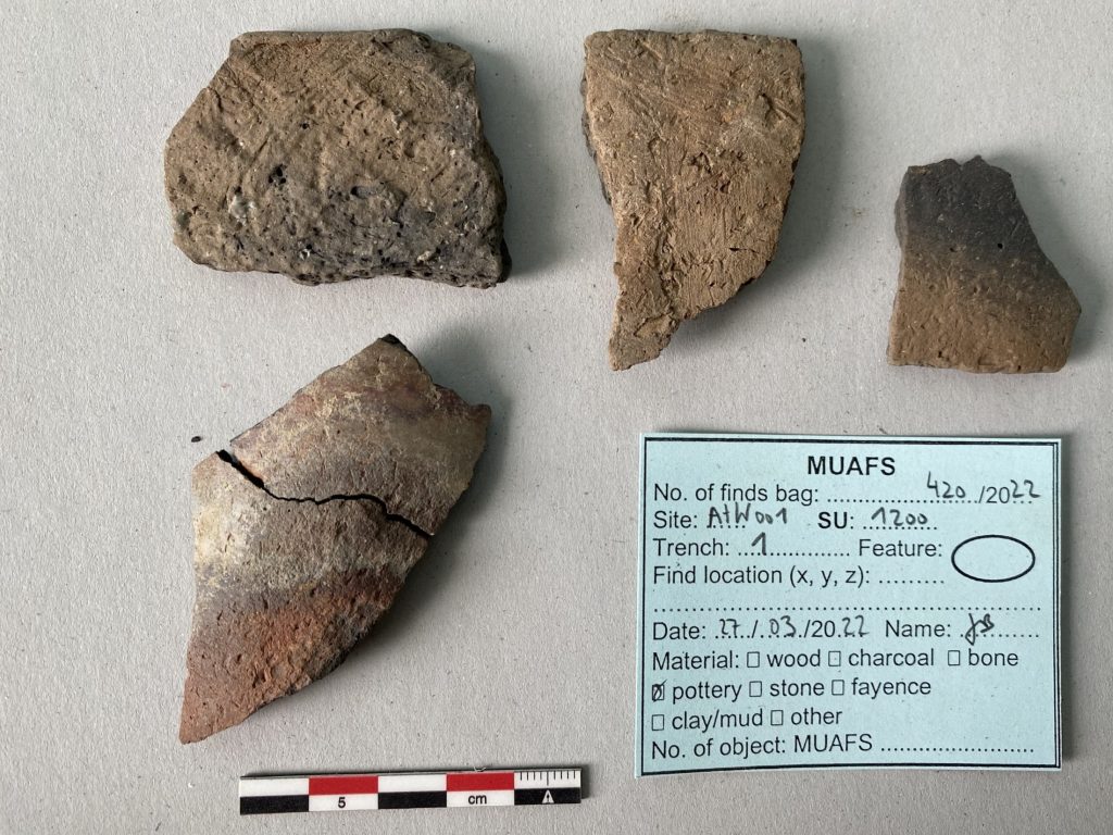
Fig. 1: One example for our new samples from the MUAFS concession – here a collection of Nubian-style sherds from the domestic site AtW 001 (photo: J. Budka).
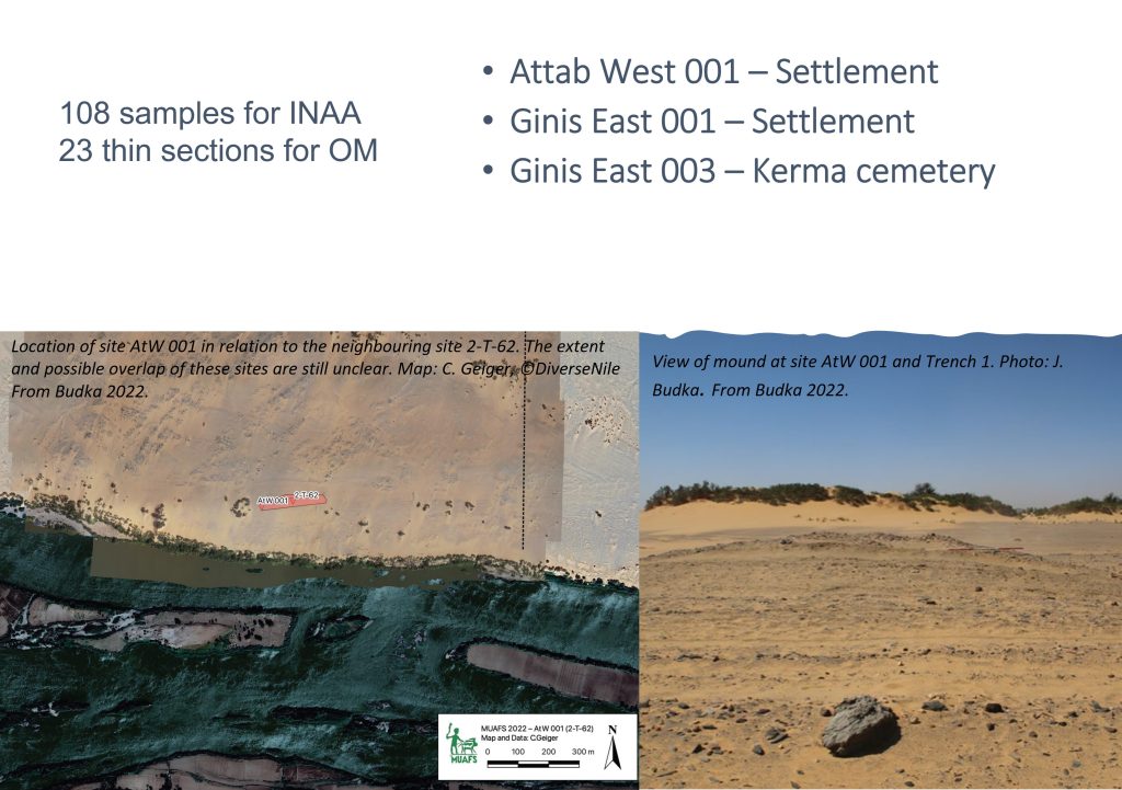
Eventually, I was keen to introduce our new set of samples – 108 beautiful and highly promising ceramic sherds, among which diverse examples of Nubian-style and Egyptian-style wares in Nile clay, selected during our last field season from the region between Attab and Ferka, namely from the sites of Attab West 001, Ginis East 001, and Ginis East 003, two settlement sites and a Kerma cemetery (Figures 1 and 2).
Fig. 2: A summary of the number and provenience of our new set of samples from the MUAFS concession.
For presenting these data, I built up a consistent theoretical frame that provided for the concepts of materiality, style, and “chaîne opératoire”. I started by talking about the meaning that we attribute to objects, not only those with high symbolic value like luxury goods or amulets, but also and above all those objects of domestic use, which we all have in our kitchens and which intersect daily with our traditions, culinary practices, gestures, and phares so that every family, and in a broad sense every culture, has not only its own family lexicon (sensu Ginzburg 1963) but also a familiar lexicon of the material culture that has belonged to it. I have therefore examined the etymology of the word object, from the Medieval Latin obiectum „thing put before“ (the mind or sight), from which comes the idea of the object aseverything that the subject (human/culture) perceives as different from himself. Hence the reference to a long tradition of philosophical and linguistic studies in which the objects, and material culture in the extended sense, has been interpreted according to an anthropocentric one-way perspective mainly as static representation of the (human) subject (for further details see Fahalander 2008). The discussion continued by examining the concept of material culture in archaeology and anthropology with reference to the academic movement of ‘Processual archaeology’ and then in accordance to the ‘post-Processualism’. Eventually, I have talked upon the recently increasing interest on ‘things and materiality’, the so-called New Materialism (see e.g., Olsen et al. 2012) and with it a new way of perceiving the material reality as centred on itself, if not freed by the human subject (it can never be completely so), at least less depended on the human apparatus of symbolic representation and functional meanings. Not by chance in the last decades, we have also witnessed a progressive change of terminology with the use of the words things and materiality gradually replaced that of material culture.
I therefore examined the concepts of materiality and style in reference to the manufacturing sequence linked to the production of Egyptian-style and Nubian-style vessels in Nile clay, with case studies from both Sai Island and Dukki Gel, and thus observed in which stages of the chaîne opératoire were the identity aspects of the aforementioned cultures and ceramic traditions more (or less) emphasized.
Looking at the ceramic manufacture not just as a finished product resulted from the human action and intended for functional, social, and representative needs, but as the outcome of a series of gestures and corporeal actions that take shape in the first place in direct contact with the environment, by means the choice and manipulation of the raw materials, implies putting ourselves in a new multi-scale perspective, so that we can move forward from the anthropocentric dimension and add to the dialectical relation objects vs. humans a third party, namely the environment with its vegetation, animals, bodies, and various materials such as clay, water and sand.
Secondly, can we ask ourselves with greater knowledge and detail “Who produced the vessels?” That is, who, among the Nubian and / or Egyptian potters having their workshops settled in Upper Nubia – most of the analysed Egyptian style and Nubian style Nile wares in Nile clay from Sai Island have showed indeed the same chemical fingerprint (D’Ercole and Sterba forthcoming) – selected the raw material for making their vessels, kneaded the pastes, and then went to shape the pots, to treat the surfaces, to apply the decorations and finally to make the fire? It is plausible to think that if not all, at least some of the gestures and stages of the manufacturing sequences took place simultaneously in the same workshop without a too rigid separation between Egyptian and Nubian production. That is, that the same potter/s possibly prepared and fired together Nubian and Egyptian style vessels and that only the stages related to the production and finishing (those where we have observed the greater diversity of style!) took place separately on the basis of specific technological skills and regional traditions.
It is still plausible to think that in such promiscuous contexts some of the so-called hybrid vessels, showing a mixture of Egyptian and Nubian stylistic aspects and technologies, have taken shape, perhaps initially accidentally, to then become objects possibly intentionally sought and widespread as the expression of a shared use of the same territory and mostly of the progressive entanglement between the Egyptian and Nubian cultures. To what extent were these isolated cases or is it realistic (and ethically correct) to speak about “Creolization” or “Koinezation” of ceramic styles? (for the term koiné and “International artistic koiné” cf., Feldman 2006).
A solid theoretical background combined with a broad-spectrum analytical approach based on the combined macroscopic and microscopic analysis of several ceramic collections from several bordering regions environmentally and culturally highly similar but also extremity distinctive (e.g., Sai Island, Kerma/Dukki Gel, and the Attab to Ferka region) is already allowing us to answer some of these questions and to formulate many others more and more punctual on the way of expanding our knowledge on the complex system of socio-cultural, economical, and ecological dynamics that took place during the Bronze Age period in the various regions of Nubia.
References
D’Ercole, G. and Sterba, J. H. Forthcoming. Chemical analyses of the pottery corpus from the New Kingdom town of Sai. In: J. Budka (with contributions by G. D’Ercole, J.H. Sterba and P. Ruffieux). AcrossBorders 3: Vessels for the home away from Egypt. The pottery corpus from the New Kingdom town of Sai Island. Archaeology of Egypt, Sudan and the Levant, Vienna: Austrian Academy of Sciences Press.
Fahlander, F. 2008. Differences that matter. Materialities, material culture and social practice (127-154). In: Glørstad, H., & Hedeager, L. eds. Six essays on the materiality of society and culture. Bricoleur Press.
Feldman, M. H. 2006. Diplomacy by Design: Luxury Arts and an ‘International Style’ in the Ancient Near East, 1400–1200BCE. Chicago: University of Chicago Press.
Ginzburg, N. 1963. Family Lexicon. Daunt Books.
Olsen, B., Shanks, M., Webmoor, T., Witmore, C. 2012.Archaeology: The Discipline of Things. University of California Press.
Four years have passed since the last International Conference of Nubian Studies in Paris and on Sunday, the 2022 edition of the 15th congress will start in Warsaw.
Rennan, Chloë and I will be attending, and I will present the MUAFS project and its main results of the last years. My paper will give an overview of our activities from 2018 until 2022, with a special focus on the ongoing subproject ERC DiverseNile focusing on the Bronze Age remains. I will introduce our landscape biography approach in the Attab to Ferka region as the investigation of encounters of humans and landscapes in a peripheral borderscape with a longue-durée perspective, considering all attested finds from Palaeolithic times until the Islamic age.
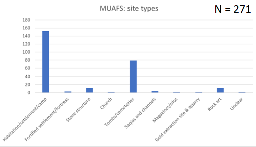
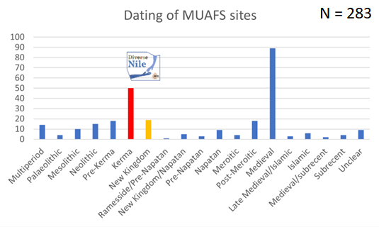
For the presentation, I updated our list of sites and processed some of the quantitative data. At present, a total of 266 sites was documented. This comprises 186 of the 219 Vila sites as well as 80 newly identified sites. This number of sites is still preliminary because parts of Kosha, Mograkka and Ferka on the West bank have not yet been surveyed.
Regarding the types of sites, the most common sites are settlements and burial grounds. However, it is also remarkable that the MUAFS concession includes one granite quarry, one gold extraction site and several rock art sites.
Main types of sites in the MUAFS concession (status 2022).
As far as the dating of the sites in concerned, the majority belongs to the Medieval time. However, Bronze Age sites, here labelled as Kerma and New Kingdom sites, which are relevant to the DiverseNile project are also well represented. There are also several multi-period sites and others were re-used in later periods (e.g. Kerma sites in Medieval times).
Dating of the MUAFS sites. Note that the total number of sites for this table is 283 since several sites were used in more than one period. The Kerma and New Kingdom sites are currently being investigated by the DiverseNile project.
I will also present some general patterns of the distribution of sites throughout the ages. This allows to highlight the importance of environmental parameters and changing landscapes in the region.
Although my last visit to Warsaw was just in May this year, I cannot wait to be back in this beautiful town. I am very much looking forward to the Nubian conference and meeting all the international colleagues working in Sudan.
The 15th International Conference for Nubian Studies in Warsaw is approaching at the end of this month, and I am currently busy preparing my paper. I will give a brief overview of the main results of the MUAFS project in the past years – and thus I revisited some of the sites of major interest between Attab and Ferka.
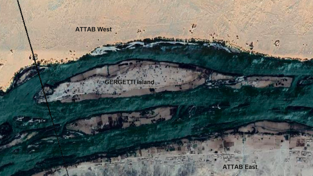
Until now, our work only focused on the left and right banks of the Nile – but my concession also comprises all the islands of the region. While we still have to visit Firkinarti island close to Ferka with its impressive archaeological remains, Huda and I spent one productive day this January on Gergetti island during our survey season.
Location of Gergetti island between Attab East and Attab West.
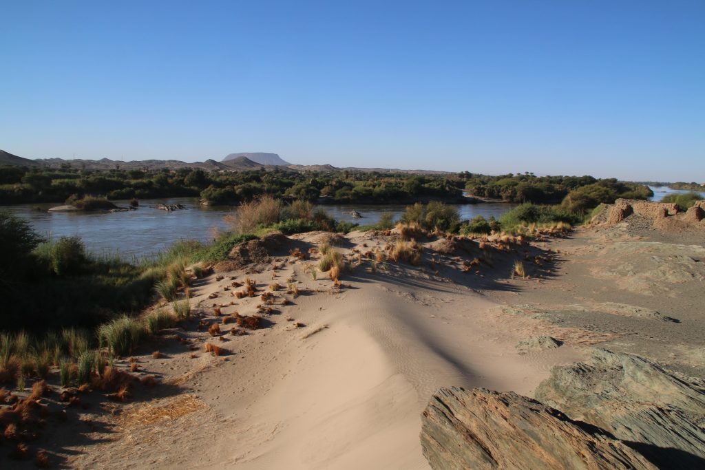
Gergetti island is a beautiful island dominated by sandy dunes, located between Attab East and Attab West with an East West extension of c. 1.7km and a North South extension of c. 250m. The landscape and the view to the east bank is stunning – and provides a completely different view of Gebel Abri than I was used to when working on Sai island.
View from Gergetti island towards the Southwest, with Gebel Abri in the background.
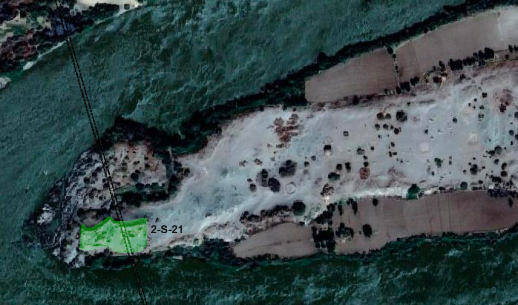
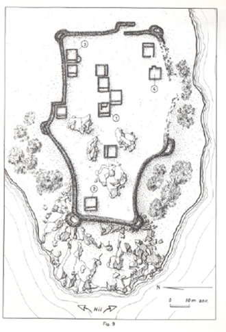
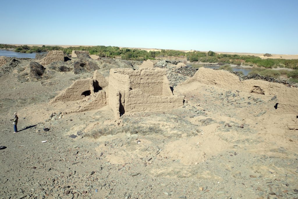
Vila documented two sites on the island – the better preserved one is 2-S-21, a fortified village of 110 x 70m in size which Vila associated with the Terminal Medieval period (Vila 1977: 32-37) in the southwestern corner of the island. He provided an excellent map of the site, and we could follow in his footsteps and check the present day preservation.
Location of site 2-S-21 on Gergetti island.
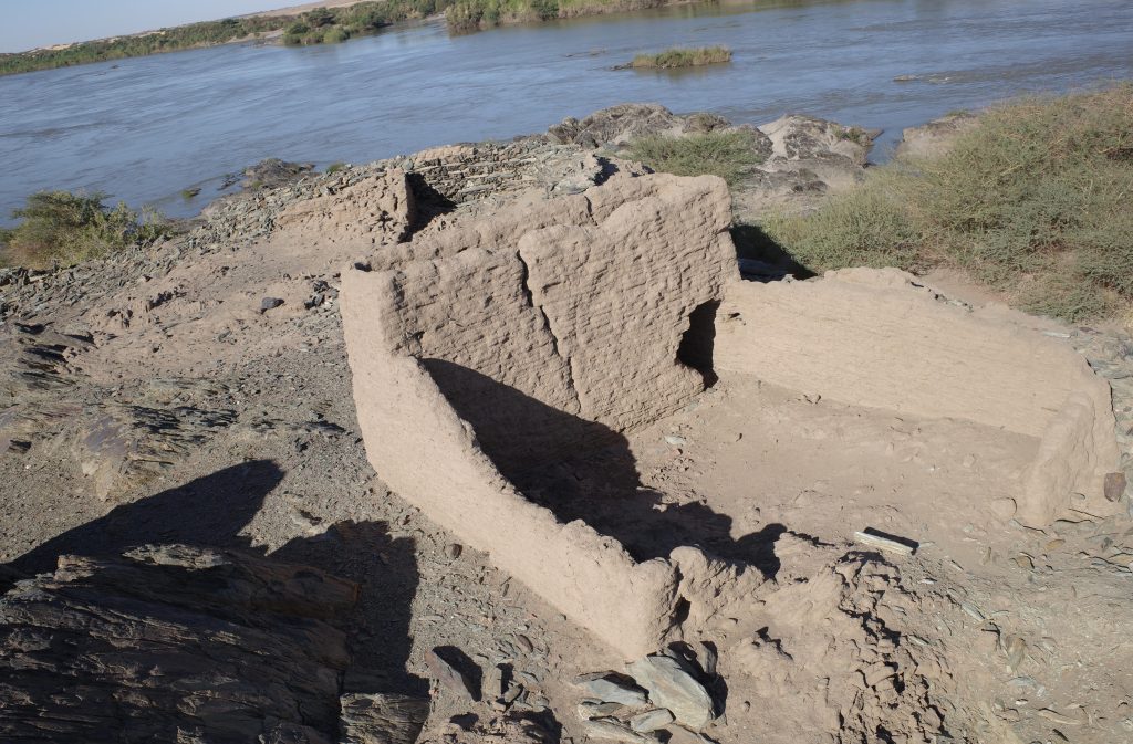
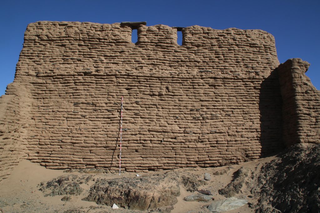
The enclosure wall has a hexagon shape and is made of mud brick with blocks and pieces of schist stone. In the southern part, the enclosure has already partly collapsed in the times of Vila, but the buildings in the interior are still very well preserved.
Plan of the fortifed village by Vila (1977).
Overview of the interior of the site in January 2022.
A dozen of preserved mud brick houses are square or rectangular buildings with one very small room in the back and a larger room in the front. Such a layout as well as the general appearance of the settlement 2-S-21 seems typical of the Funj period. Much progress in research on Funj house architecture has just been made in the last years, most prominently by the UMMA project at Old Dongola. In one of their recent publications, Obłuski and Dzierzbicka point out the main characteristics and differences to the medieval Nubian house types. They also mentioned Gergetti island as a close parallel to Old Dongola (Obłuski & Dzierzbicka 2021, 237, 242).
One of the houses along the northern wall (view to west).
Especially since research of Funj period domestic architecture between the Second and Third Cataracts is still limited, the site 2-S-21 has much potential for future exploration. It became obvious that the map of Vila, as useful as it is, needs to be improved in several respects and that some buildings were also omitted on his plan. One possibility would be to document the site by drone aerial photography and thus to generate a new georeferenced 3D model as well as detailled plans. Excavations should also be undertaken in selected parts of the town, especially for clarifying building phases. The earliest phase of the settlement would be extremely relevant – not only for further comparisons with Old Dongola and other sites, but also from a historical view for the region of Attab to Ferka. Apart from the architecture, the material culture will give important information on the fine dating (as well as on so many other questions like room function, activities etc.). There is plenty of pottery on the surface, including nice painted wares and we also found one small piece of glazed ware. Without doubt, undisturbed contexts more useful for dating can be expected below some of the collapsed walls.
The state of preservation of the buildings at 2-S-21 is just amazing.
For now, Vila’s association of the site with Late Medieval times should be modified as most likely Funj period – more on this will follow when we return to the beautiful island of Gergetti.
References
Obłuski, A. and Dzierzbicka, D. (eds) 2021. Old Dongola: development, heritage, archaeology. Fieldwork in 2018-2019. Volume 1: Excavations. Polish Publications in Mediterranean Archaeology 1. Leuven et al.
Vila, A. 1977. La prospection archéologique de la Vallée du Nil, au Sud de la Cataracte de Dal (Nubie Sudanaise). Fascicule 6: Le district de Attab, Est et Ouest. Paris: CNRS.
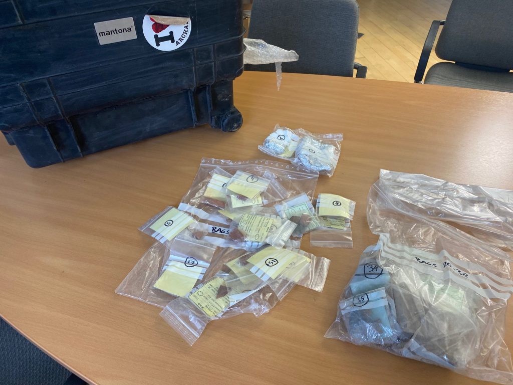
One of our objectives within the DiverseNile project, to reconstruct cultural encounters based on the material record by the detailed assessment of the most important productive activities, technologies and foodways, has received plenty of new material evidence during the 2022 excavation season. Most importantly, thanks to the support of NCAM and especially our inspector Huda Magzoub, I was able to export a selection of pottery samples for scientific analysis to Germany. These new samples from our excavations in Ginis East (sites GiE 001 and 003) and Attab West (site AtW 001) are of huge importance for the project, especially because due to the restrictions caused by the corona pandemic for archaeological fieldwork in the last two years, we could until now only investigate the petrography of ceramic samples from Dukki Gel.
Such a privilege: unpacking ceramic samples in Munich just one month after excavating the sherds and their contexts in Sudan!
This ties in with what our PostDoc Giulia D’Ercole has summarised in a recent paper: „For over seventy years, theoretical approaches and methods of classification of ceramic objects in Sudan have gradually changed, as have the perspectives and the general purposes of archaeological research. In general, scholarly attention has progressively shifted from forms (i.e., decoration and shape) to mineral and chemical compositions of ceramics and vessel contents (i.e., petrographic, compositional, and organic residue analyses)“ (D’Ercole 2021). This changed focus already influenced our research within the framework of the AcrossBorders project and is now continued with the DiverseNile project.
The analysis of the material culture in Work Package 3 of the DiverseNile project is undertaken from a multi-perspective level, including scientific analyses focusing on provenience studies (e.g. ceramic petrography and iNAA, see already D’Ercole and Sterba 2018). For the ceramics, we will combine macroscopic observations with analytical approaches and evaluate the results of optical microscopy (OM) and chemical analyses (XRF and iNAA) in conjunction. Together with LMU colleagues, Giulia has also introduced Raman spectroscopy as a new application to answer various technological questions, in particular on the manufacturing stages of production and firing of the pots. This will especially help to understand questions about local productions and influences of Nubian ceramic traditions for preparing wheel made pots in the Middle Nile region.
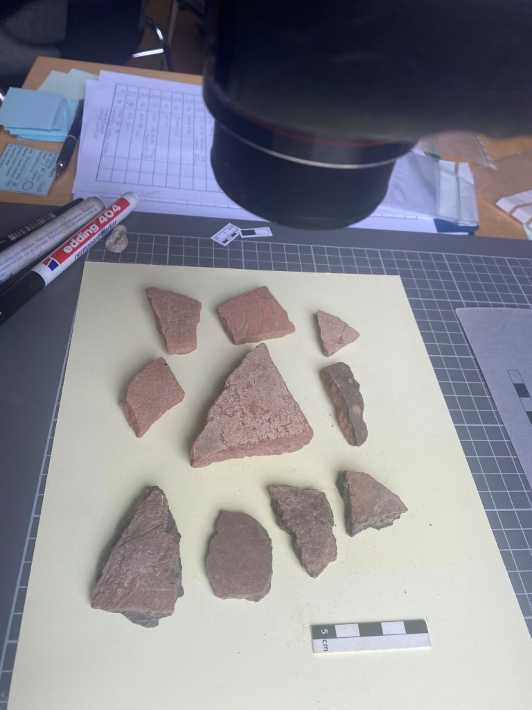
In the last days, I was busy preparing the documentation of our new ceramic samples from Ginis East and Attab West. I selected twenty-one samples for optical microscopy (OM) and thus for the preparation of thin sections, while I will bring 108 samples later this week to the Atominstitute in Vienna where they are being analysed for instrumental Neutron Activation Analysis (iNAA) by our colleague and external expert in the project, Johannes Sterba.
Documenting a set of early New Kingdom samples from Attab West.
The new samples comprise sherds of various surface treatments and different fabrics of the Kerma ceramic tradition as well as diverse Egyptian style wheel made samples of which the majority seems to attest to a local pottery production in the Attab to Ferka region. Photographing the samples, I was again struck by the extremely interesting appearance of the material from the domestic site AtW 001. Although I know that the scientific analyses will take some time and I need to be patient, I cannot wait to integrate the results from iNAA and petrography with my archaeological assessment and macroscopical observations and discuss them further with Giulia and Johannes.
Like Aaron M. de Souza and Mary F. Ownby very truly remarked in a recent paper: more micro-analyses of Nubian material culture need to be undertaken to achieve a better understanding of cultural diversity in the Middle Nile (de Souza and Ownby 2022, 55).
References
D’Ercole, G. 2021. Seventy Years of Pottery Studies in the Archaeology of Mesolithic and Neolithic Sudan. Afr Archaeol Rev 38, 345–372. https://doi.org/10.1007/s10437-021-09432-y
D’Ercole, G. and Sterba, J. H. 2018. From macro wares to micro fabrics and INAA compositional groups: the Pottery Corpus of the New Kingdom town on Sai Island (northern Sudan), 171–183, in: J. Budka and J. Auenmüller (eds.), From Microcosm to Macrocosm: Individual households and cities in Ancient Egypt and Nubia. Leiden.
de Souza, A.M., Ownby, M.F. 2022. Re-assessing Middle Nubian cultural constructs through ceramic petrography. Afr Archaeol Rev 39, 35–58. https://doi.org/10.1007/s10437-022-09473-x
One thing that always strikes me on excavations is the bizarre feeling of time one develops – it seems ages ago that we left Munich, but also years ago that we closed the excavation in Attab West (on March 31) and also as if at least a week has passed since we left Ginis yesterday morning!
Well – here we are – getting ready to leave this beautiful country with its rich archaeological and cultural heritage tonight after a very successful season´and a busy day in Khartoum with final paperworks and preparing accounts.
A summary of the 2022 spring season will follow soon – for now I am really grateful to all international team members, our wonderful inspector Huda Magzoub and all the other extremely helpful Sudanese colleagues at NCAM! Many thanks!
We collected large amounts of data from Ginis as well as Attab that will keep us busy in the next months! And hopefully we will be back in our concession area with its stunning landscape later this year!
Week 5 of our 2022 spring season is almost finished and we are getting ready to leave to Khartoum early next week.
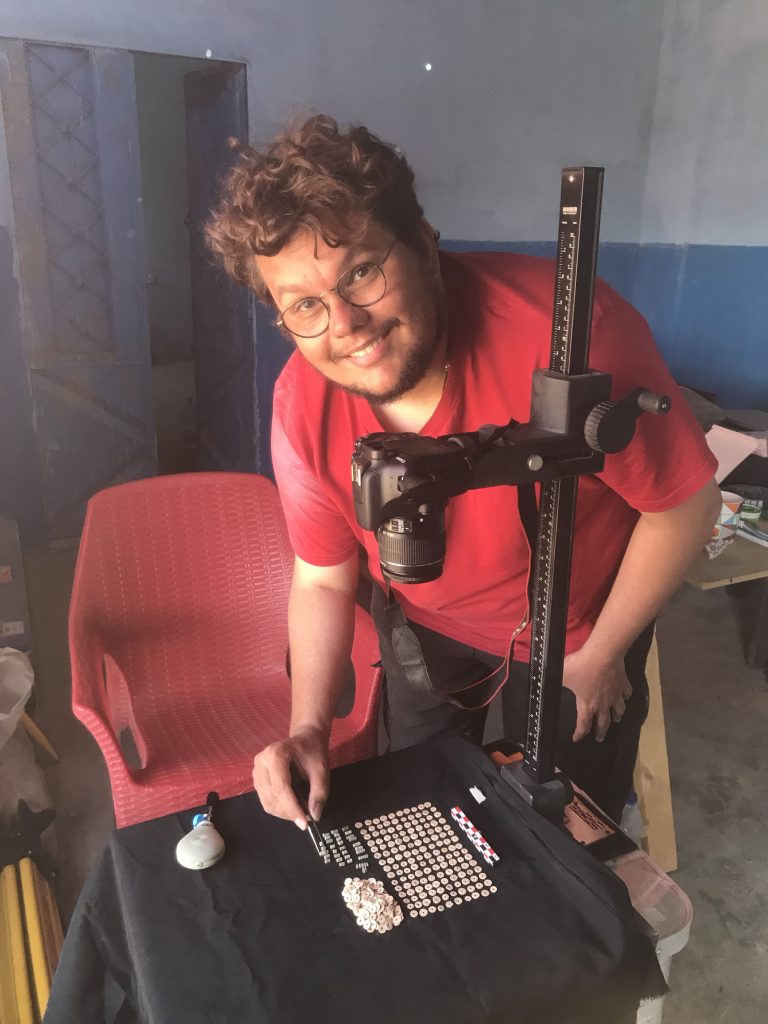
We made great progress processing and documenting our recent finds. Sawyer and I were busy with drawing pottery and small finds, Rennan took last photos (Fig. 1). A special focus was on the rich material from the Kerma cemetery GiE 003.
Fig. 1: Rennan was busy photographing beads and other objects from GiE 003.
Because of the large amounts of ceramics, I could spend less time than I hoped for the continuation of the survey. Nevertheless, I managed to document some nice sites in the close vicinity of our digging house. For example, I re-traced the site labelled by Vila as 2-T-23 in Ginis East. Here, dwellings and remains of four saqiyas of a Medieval village are situated on a length of 1500m in the alluvial plain, still partly preserved. Sherds are scattered around the site which is now in parts covered by modern fields and has suffered from some destruction by car tracks.
One of the saqiya Vila documented in the 1970s is especially well preserved (Fig. 2). Recording this site was extremely pleasant because the setting close to the Nile is simply beautiful. One just needs to avoid the early morning hours – since it is hot, the nimiti flies are quite numerous at this time of the day.
Fig. 2: One of the stone-built saqiyas of site 2-T-23.
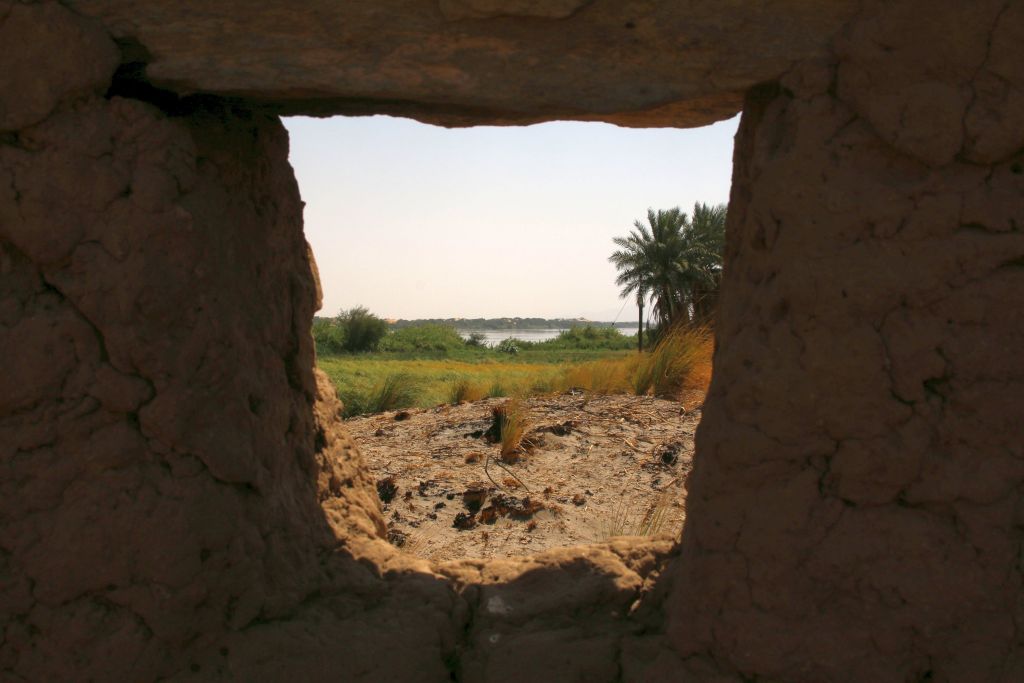
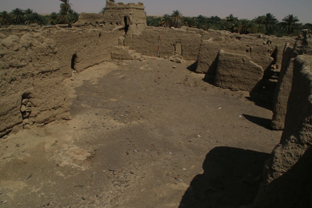
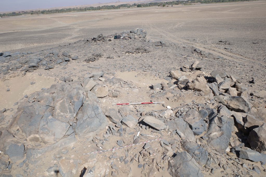
Yesterday, I covered another stretch of the east bank of the MUAFS concession and went to its very south-western part in Attab East. Here, the most spectacular monument is the extremely well preserved Islamic fortress Kourfa Hemmet, 2-T-57 (Fig. 3), which is surrounded by some Late Medieval remains. In this part of Attab, the Nile is very close to the sites, with a narrow strip of fields and one can already make out the Amara cataract in the water.
Fig. 3: View of the inner courtyard of the islamic fortress 2-T-57.
All these important monuments in a beautiful setting underline the general richness of archaeological sites in the MUAFS concession – and luckily we still have a few more days left in this gorgeous and peaceful part of northern Sudan!
While the first weeks of our 2022 season focused on mortuary remains and excavations in cemeteries, first of all the Kerma cemetery GiE 003, we switched focus and location in our week 4.
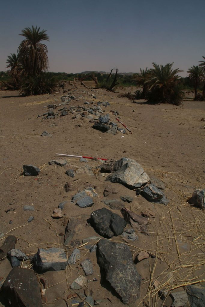
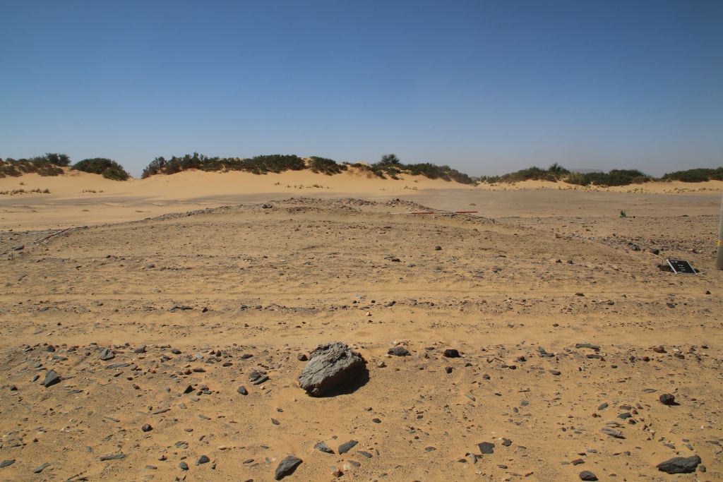
Earlier this year during our MUAFS survey, I noted an extremely interesting site at Attab West, with loads of early 18th Dynasty potsherds as well as scatters of local schist pieces on the surface. This site, AtW 001, is a small almost circular mound (Fig. 1). Unfortunately, the new line of electricity runs right through the site and seems to have destroyed part of it. This week, we went back there and excavated one trench as a first check of whether stratigraphy is preserved and any structures are traceable.
Fig. 1: Work in Week 4 focused on site AtW 001 at Attab West. View of Trench 1 to the south, with the loose surface removed. The mound covered with potsherds and schist pieces on the surface is still visible in the back.
It was our first excavation on the west bank, which differs considerably from the east bank in terms of landscape and general conditions. Logistics are a bit more complicated as well, bringing the team and the equipment to the site by boat and through large sandy dunes with picturesque tamarisks.
In sum, the test excavation at AtW 001 was a challenge but also very rewarding – we found what can be classified as domestic rubbish, loads of ashy deposits, plant remains, animal bones and lots of pottery sherds as well as debris from fires and other everyday activities. The ceramics are nicely datable to the early 18th Dynasty to Thutmoside times. Interestingly, the amount of Nubian wares in the various horizons of fill was really high, accounting to ca. 30% of the ceramics. The lower fills only had very little ceramics inside and here the Nubian wares were more common than Egyptian style wheelmade pots – this is just a first impression and I will follow up on this with a more detailed assessment soon!
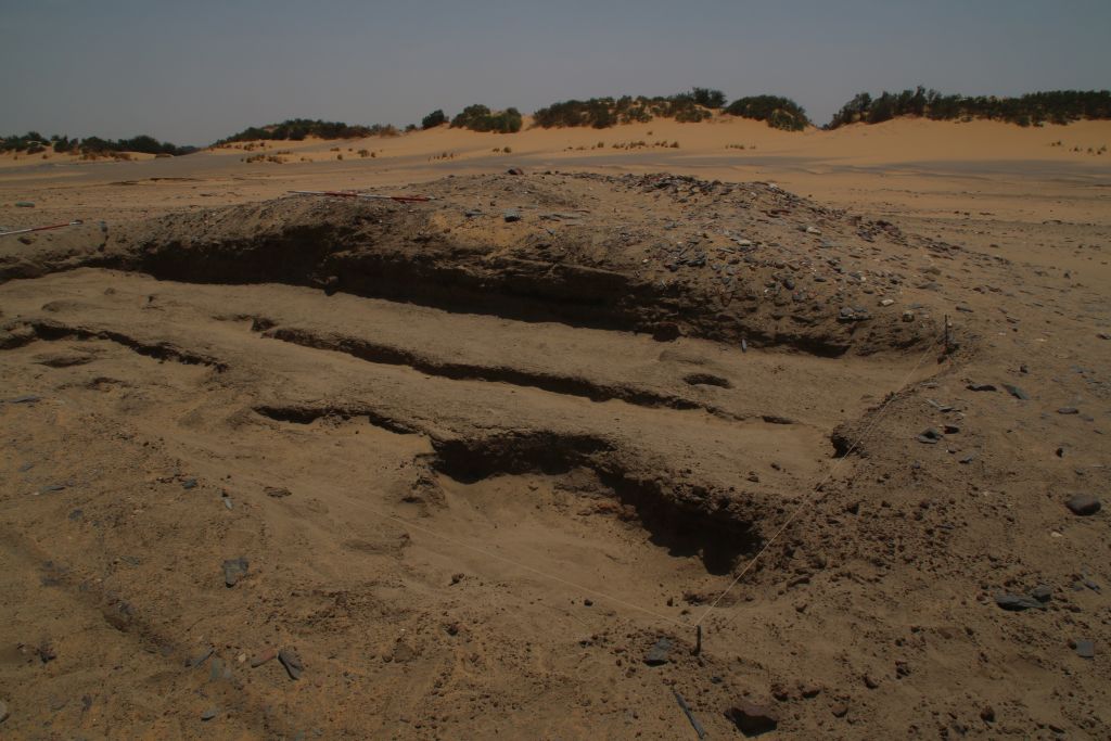
We seem to have at least two phases of activity in the New Kingdom period preserved, possibly an early phase and a slightly later one which can be dated to Thutmose III. Remains of collapsed mud bricks and overfired sherds indicate the former existence of buildings and possible also ovens or kilns, but no standing remains of architecture was identified up to now. There were several homogenous deposits of silt, partly showing some ash. The ashy spots of the earliest phase are directly on top of the natural alluvium, suggesting that we either have an open courtyard or maybe part of the periphery of a domestic site. Apart from ceramics, the finds included some grindstones and stone tools like pounders, testifying to some grinding and crushing activities. However, many questions about this site are still open and AtW 001 needs to be excavated on larger scale in the near future.
Fig. 2: Final status of Trench 1 at AtW 001 in 2022 – there is still much work waiting for us at this domestic site!
Overall, our site finds a perfect parallel in the nearby site 2-R-18 in the desert hinterland of Amara West (Stevens and Garnett 2017, previously documented by Vila in the 1970s). As highlighted by Anna Stevens and Anna Garnett, there were also rubbish deposits above homogenous deposits of silt and ash, which seem to have accumulated directly on top of the natural surface. Similar to our site, no traces of architecture were preserved at 2-R-18. The material culture, especially of the pottery and the stone tools, is extremely well comparable to our finds. The dating to the early 18th Dynasty is also almost identical.
Thus, the results of our trench are clearly promising and work at AtW 001 will continue in the near future. Especially the function and duration of use of this site will make a considerable impact to our aims of addressing seasonal sites as well as sites connected with gold working (as suggested by Stevens and Garnett 2017 for 2-R-18 and other desert hinterland sites) and other activities in the 18th Dynasty periphery of Sai Island.
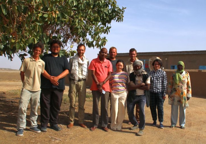
With the final day of work at AtW 001 yesterday, our fieldwork with workmen and excavation has come to an end – just in time before Ramadan starts tomorrow. Part of the team – all of them fully recovered from the corona infection by now – has already left and is heading back to Vienna and Munich. A small team will continue with processing finds here at Ginis and documenting the rich material culture from our very successful excavations in 2022.
Fig. 3: Group picture of the DiverseNile 2022 fieldwork team.
Many thanks go to all team members of 2022 – it has been a challenging season with so much wind, cold weather, covid-19 and a dense excavation programme at four different sites. The results are clearly remarkable and I am very grateful to all! For now, I am really keen to process the new material in more detail in the upcoming week.
Reference
Stevens and Garnett 2017 = Stevens, A. and Garnett, A. 2017. Surveying the pharaonic desert hinterland of Amara West, 287‒306, in: N. Spencer, A. Stevens and M. Binder (eds.), Nubia in the New Kingdom. Lived Experience, Pharaonic Control and Indigenous Traditions. British Museum Publications on Egypt and Sudan 3. Leuven.
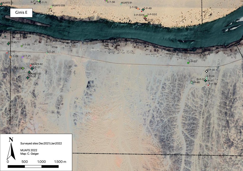
During our short season in December 2021/January 2022, we were able to record 14 sites on the East bank of the district of Ginis. These are 12 sites previously recorded by Vila as well as two new MUAFS sites (Fig. 1).
Fig. 1: Recorded sites in Ginis East, Dec. 2021/Jan. 2022. Map: C. Geiger.
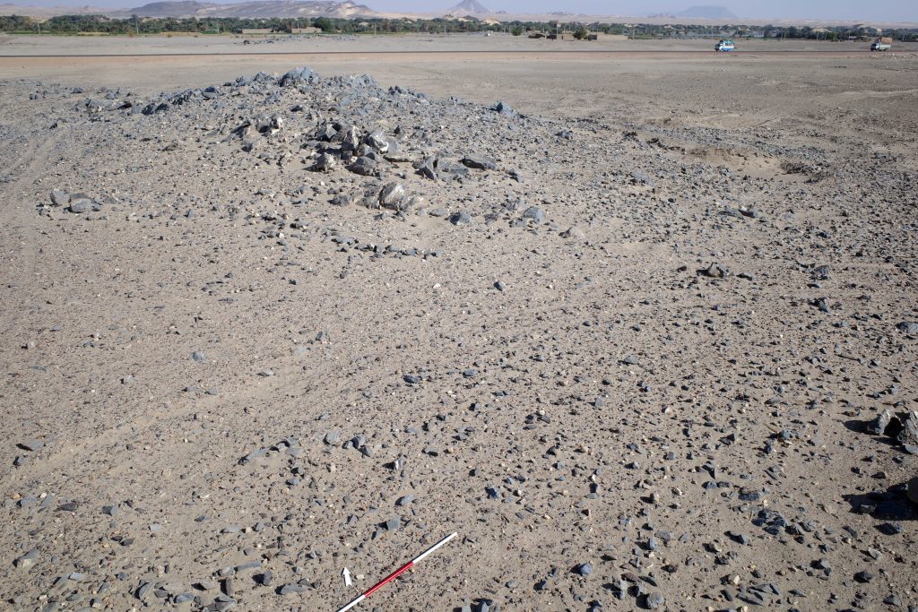
One particularly noteworthy site is the Abkan occupation site 2-T-21 at Ginis East, on a hill above the modern asphalt road (Fig. 2). According to the current chronologies, the Abkan period is dated to between c. 5500 and 3700 cal BCE (see D’Ercole 2021 with discussion and references).
Fig. 2: Overview of site 2-T-21. Photo: J. Budka.
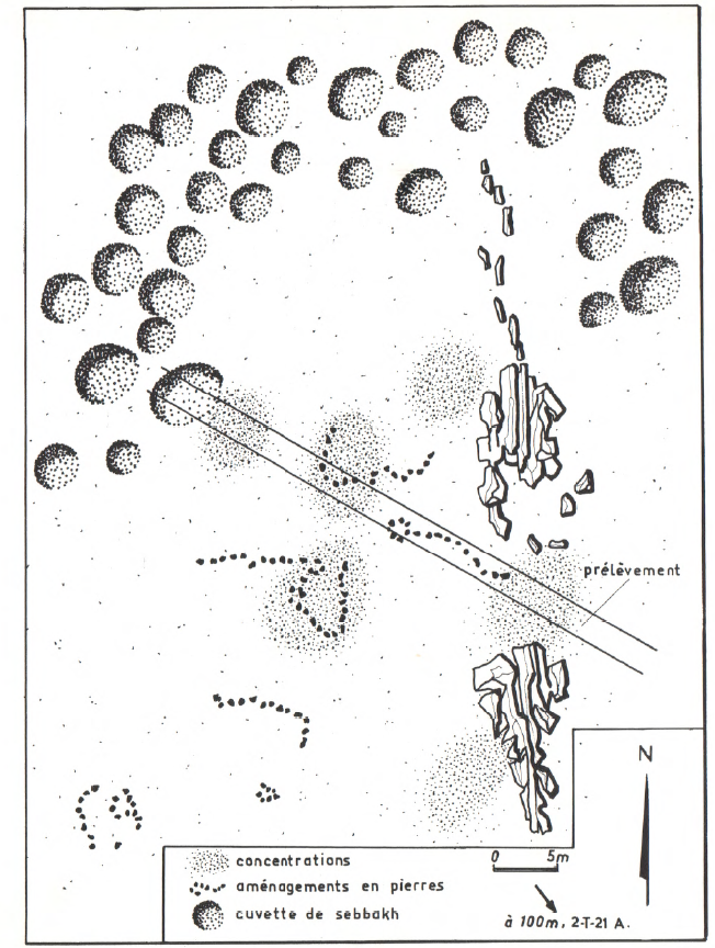
We could note that the meticulous documentation by Vila (1977) for 2-T-21 was correct (Fig. 3). Many diagnostic pottery sherds are still scattered on the surface. This site is clearly worth a more detailed investigation, although it has recently suffered from modern destruction like car tracks running through the site.
Vila’s sketch map of site 2-T-21 (Vila 1977, 60, Fig. 23).
Significant traces of Abkan occupation were recently documented by Elena Garcea on the island of Sai (Garcea 2020, 50 and 94 with references). The contemporaneous sites in our concession, of which several were documented on both riverbanks in Attab and Ginis, hold much potential and have received until now only little attention. Especially the relations of the Neolithic Abkan sites to Khartoum Variant sites in the region between the Dal Cataract and Sai Island needs to be explored in detail, not only regarding the chronology and possible overlaps but also in terms of subsistence strategies of these prehistoric communities as semi-sedentary hunter-gatherers and/or herding groups. This ties in with general questions about changes in the settlement strategies by Mesolithic groups compared to Neolithic communities (see D’Ercole 2021). Furthermore, until today, no cemeteries of the Abkan cultural complex have been identified – a highly unusual feature for a Neolithic culture in Sudan and something worth investigating in the future. Maybe the region between Attab and Ferka will provide some answers in this respect.
References
D’Ercole, G. 2021. Seventy Years of Pottery Studies in the Archaeology of Mesolithic and Neolithic Sudan. Afr Archaeol Rev 38, 345–372. https://doi.org/10.1007/s10437-021-09432-y
Garcea, E. 2020. The Prehistory of the Sudan. Springers Briefs in Archaeology. Cham.
Vila, A. 1977. La prospection archéologique de la Vallée du Nil, au Sud de la Cataracte de Dal (Nubie Soudanaise). Fascicule 5: Le district de Ginis, Est et Ouest. Paris.
We have returned safely from Sudan and our short preparation season of the Munich University Attab to Ferka Survey Project (MUAFS) in its research concession between Attab and Ferka from Dec. 29 to January 9 was very successful.
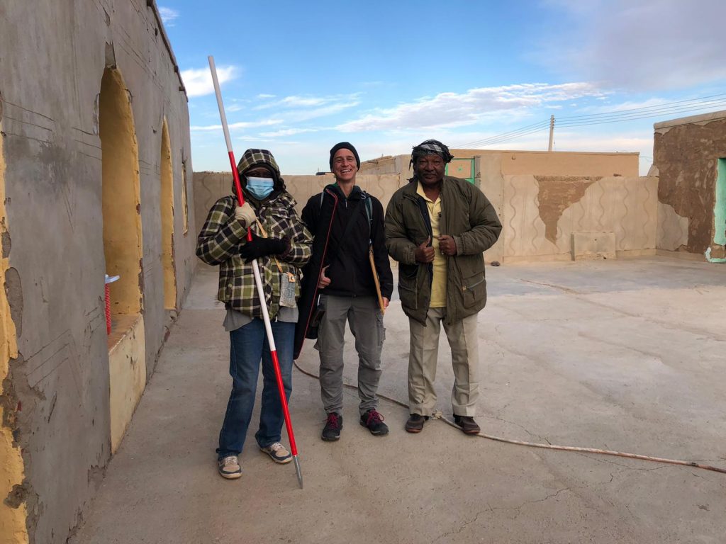
Huda, our driver Saif and I getting ready to leave for another day of surveying the area (photo: C. Geiger).
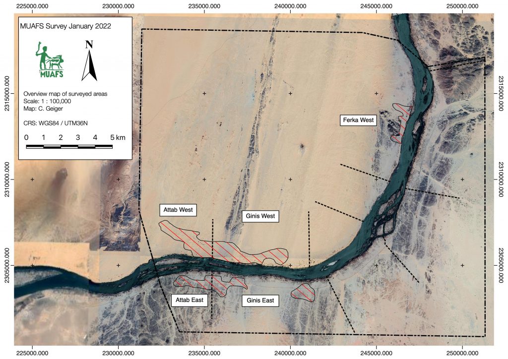
Huda and I conducted a foot survey in areas of Attab East, Attab West, Ginis East, Ginis West and Ferka West. The focus was on the identification of sites already recorded by Vila. We were able to document a total of 79 sites, comprising 21 new MUAFS sites. The sites range in date from Palaeolithic times to the Medieval and Ottoman eras. The types of sites are mostly camp sites, habitations, and tombs/cemeteries, but also include rock art and stone wadi walls.
Surveyed area of the 2021/2022 season (map: C. Geiger).
Whenever possible, we collected diagnostic pottery and lithics from the sites for dating purposes. I was able to document most of them by photography and also managed to draw 35 Kerma and New Kingdom sherds. Most interesting are some newly documented New Kingdom sites, attesting to both a use in the 18th Dynasty and a Ramesside presence in the periphery of Amara West.
One example of a newly documented site, unfortunatly recently plundered (photo: J. Budka).
One particularly striking site, a cluster of cleft tombs at Ginis East, has never been documented before but was unfortunately lately plundered. And this is not an isolated example! Recent plundering, modern gold working, new electricity lines and damaged caused by car tracks, roads and new buildings are unfortunately very frequent, have increased since 2020 and stress how urgently we need to document this rich area in the Middle Nile.
The surveying campaign carried out by Cajetan resulted in the setup of new benchmarks using a GPS Antenna and a totalstation in Attab East, Ginis East and Ginis West. We will use these benchmarks as basis for future measurements during our planned excavations. Drone aerial photography was successfully conducted in Ginis East, Ginis West and Ferka West.
All in all, I am very grateful to the support of our Sudanese friends and colleagues – without them our work at site would not have been possible in these very difficult times of political changes. We collected a large amount of new data and will now be very busy processing these here in Munich – and of course we will keep you updated.