
I studied various cemeteries throughout Nubia for my PhD on the role of foreign objects in local contexts in New Kingdom colonial Nubia. The most important of these cemeteries are Aniba, Sai and Soleb. Other important cemeteries are either gradually coming to light (e.g., Amara West) or remain totally unpublished (e.g., Sesebi). I was interested mostly in variation across sites, which I explored through an analysis of distributions of types of objects at each of them. However, the sites that I just mentioned also have a lot in common.
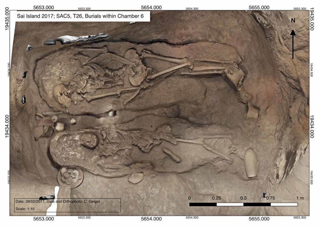
One of the aspects that instantly caught my attention was the collective use of tombs, both synchronically and diachronically. It is interesting how Egyptologists usually interpret New Kingdom Nubia through the lens of Egyptianisation, but at the same fail to recognise one structural difference between the organisation of elite cemeteries in Egypt and Nubia in the New Kingdom. While elite tombs in Egypt, in places such as Thebes, bear an essential connection with one’s individuality, tombs at elite cemeteries in Nubia are essentially collective. One well-documented example is tomb 26 on Sai island, which will be published very soon (Budka 2021).
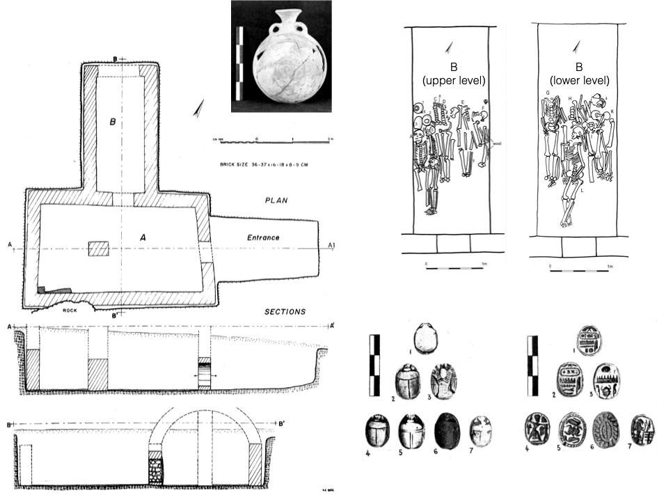
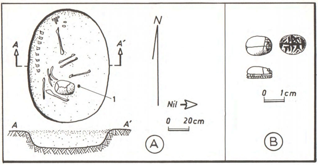
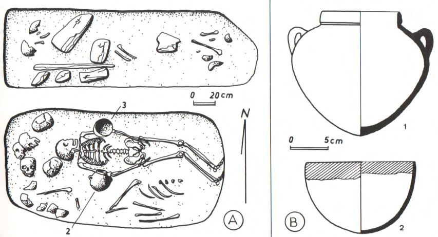
These tombs are usually interpreted as family tombs, which remains a plausible hypothesis. Elite tombs in New Kingdom Nubia usually consist of a vertical shaft leading to a main chamber connected with various smaller burial chambers. Inside these smaller chambers, there are the burials of more or less contemporary individuals. Individual chambers are usually occupied by “couples”; e.g. Khnummose and his alleged wife at Sai tomb 26 (figure 1) and Wsir and Taneferet at Aniba tomb S91. Later burials are usually placed in the larger main chamber, where archaeologists usually find scattered bones, and disarticulated skeletons alongside New Kingdom Egyptian-style objects and later pottery styles in upper layers. In extreme cases of tomb reuse, vertical shafts could be completely filled with burials, one on top of the other, as evidence from Soleb demonstrates.
If we move to non-elite contexts we’ll find a different situation. In a context of overall material limitations, cemeteries are characterised by a vast majority of single burials possessing no burial goods or a few pots. The best example of non-elite cemetery in New Kingdom Nubia is Fadrus, which bears similarities with various non-elite cemeteries in New Kingdom Egypt in terms of scarcity. However, at Fadrus, a few larger tombs contained a considerably higher quantity of burial goods. These tombs are characterised by their collective use, both contemporaneously and by later generations.
I have suggested in a paper that will be published in the next Sudan & Nubia that the larger, collective tombs of Fadrus should not be interpreted as evidence for inter-site hierarchies, as has been done in the past. Instead, in my forthcoming paper, I suggested that these tombs should be interpreted through the lens of collective engagement theory (DeMarrais and Earle 2017; Lemos forthcoming). In a context of scarcity within a colonised Nubia, people seem to have gathered together to achieve more, namely access to Egyptian-style objects, including more restricted items within the New Kingdom Nubian mortuary landscape. On the contrary, those who remained by themselves ended up buried with no accompanying goods. It is possible that a similar collective logic was behind the organisation of cemeteries associated with Egyptian temple-towns such as Aniba, Sai and Soleb. However, it remains a difficult task to distinguish phases and individual burials sharing restricted Egyptian-style objects due to the high degree of plundering and the quality of most of the published evidence (see Näser 2017).
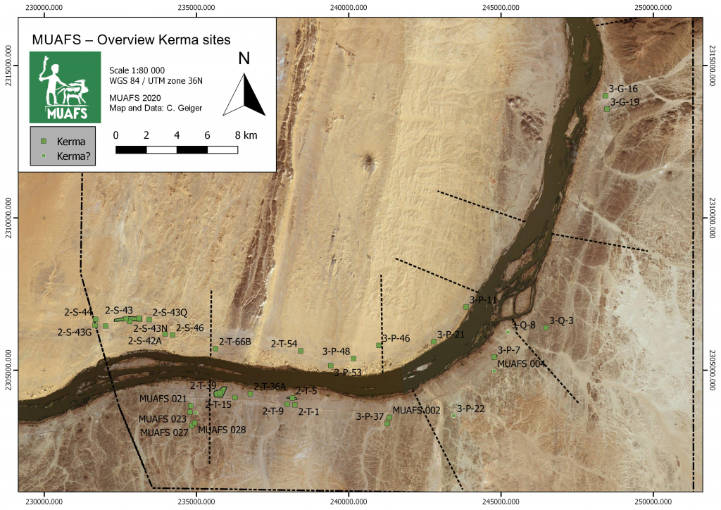
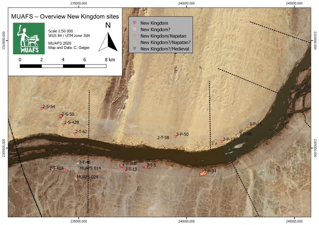
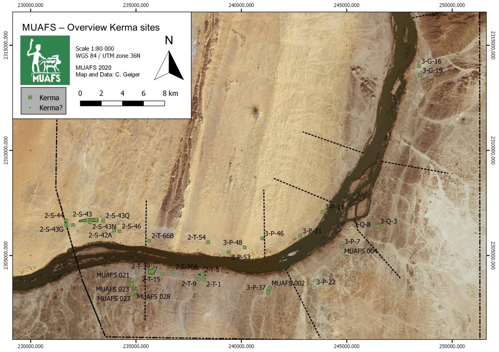
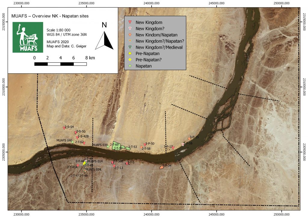
With DiverseNile, my focus turns to a different social space: geographical peripheries of temple-towns. Elite cemeteries associated with colonial centres seem to have been organized by extended families buried in collective tombs which were later reused. Non-elite cemeteries consisted of mostly poor individual graves with a few larger collective tombs housing the bodies of individuals potentially sharing objects that remained out of the reach of most their peers. In a different way, the burial evidence from the peripheries usually consist of graves scattered through the landscape with and a few ‘formal’ cemeteries. Scarcity also seems to be the rule here. However, there are also collective exceptions.
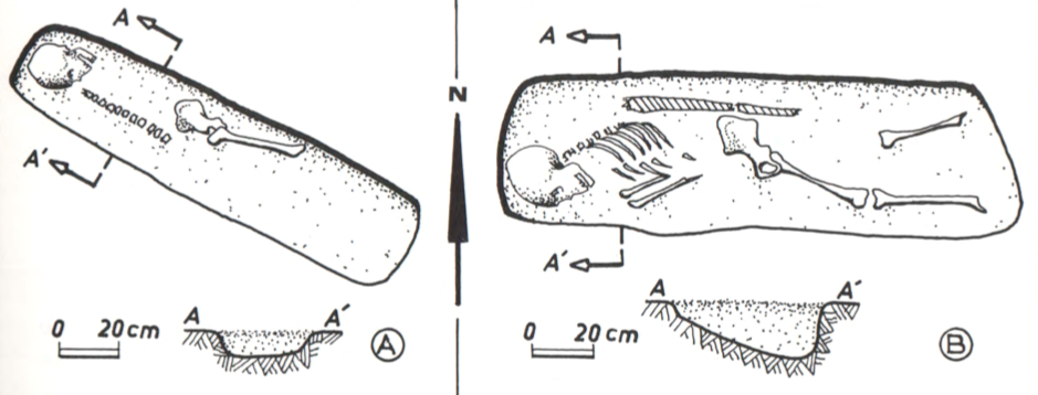
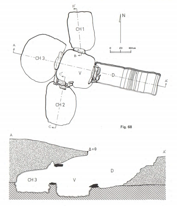
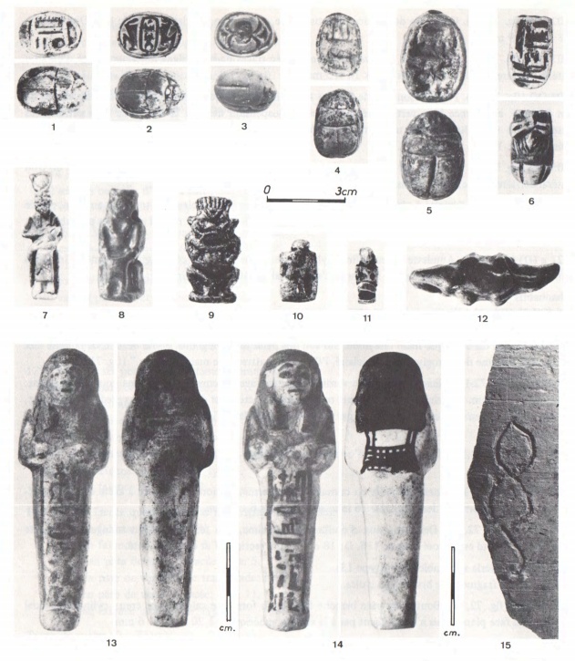
Chamber tomb 5-T-32 was among the sites excavated by the West Bank Survey from Faras to Gemai in Lower Nubia (figure 2). It consisted of a shallow mudbrick tomb divided into an entrance area leading via an unblocked arched doorway to an outer chamber or chapel, and a sealed arched doorway leading to the burial chamber. The tomb was located in the periphery of Mirgissa, one of the earlier fortresses reoccupied in the New Kingdom, and was plundered in ancient times. The excavators dated the tomb to the mid-18th Dynasty. The fact that no burials were placed in the outer chamber distinguishes tomb 5-T-32 from tombs at elite cemeteries associated with centres of colonial administration, such as nearby Aniba. The remains of 38 individuals were recovered from the burial chamber, eleven of which in situ. The bodies were deposited in an extended position, and remains of wood and rope suggest the existence of simpler mat coffins tied with ropes, which also appear in non-elite contexts in Egypt. Finds include steatite scarabs with parallels found at various Nubian cemeteries, New Kingdom pottery including a pilgrim flask, and a bronze finger ring and wooden headrest, which were more restricted objects in the Nubian mortuary objectscape of the New Kingdom.
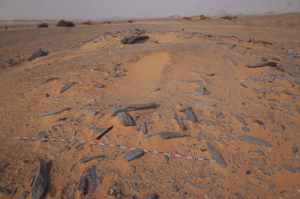
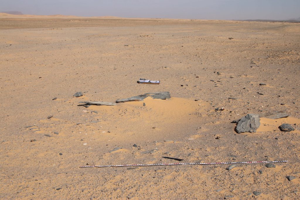
In a previous post, I discussed tomb 3-P-50 at Ginis West containing some nice restricted Egyptian-style objects, despite its tumulus superstructure. Although the tomb was plundered, with only scattered bones being recovered, it was most likely used collectively. After looking at the evidence from tombs such as 5-T-32 and 3-P-50, located in the periphery of Mirgissa and Amara West, respectively, I started feeling like there’s something happening here. At this stage, I’m still scratching the surface, but I think it’s probably a good idea to keep pursuing the communal engagement path to see what we can potentially learn from the peripheries of colonised Nubia. Therefore, I was especially happy to hear Andrea Manzo talk about heterarchy and communal engagement in Eastern Sudan in our last DiverseNile seminar (see also Manzo 2017). Degrees of variations can be detected amid elite sites, while evidence from non-elite sites provides us grounds from which to discuss alternative social realities taking place in colonised Nubia. I don’t really know what to expect from the colonial peripheries, but I’m optimistic evidence from these areas will allows to expand the discussion on alternative social realities, especially in the light of fresh excavations planned for the near future.
Further reading
Budka, J. 2021. Tomb 26 on Sai island: A New Kingdom elite tomb and its relevance for Sai and beyond (with contributions by J. Auenmüller, C. Geiger, R. Lemos, A. Stadlmayr and M. Wohlschlager). Leiden: Sidestone Press [in press].
DeMarrais, E. and T. Earle. 2017. Collective Action Theory and the Dynamics of Complex Societies. Annual Review of Anthropology 46: 183–201.
Lemos, R. 2020. Material Culture and Colonization in Ancient Nubia: Evidence from the New Kingdom Cemeteries. Encyclopedia of Global Archaeology, ed. C. Smith. https://doi.org/10.1007/978-3-319-51726-1.
Lemos, R. forthcoming. Heart Scarabs and Other Heart-Related Objects in New Kingdom Nubia. Sudan & Nubia 25.
Manzo, A. 2017. Architecture, Power, and Communication: Case Studies from Ancient Nubia. African Archaeological Review 34: 121–143. https://doi.org/10.1007/s10437-016-9239-6.
Näser, C. 2017. Structures and Realities of the Egyptian Presence in Lower Nubia from the Middle Kingdom to the New Kingdom. In Nubia in the New Kingdom: Lived Experience, Pharaonic Control and Indigenous Traditions, ed. N. Spencer, A. Stevens and M. Binder, 557– 574. Leuven: Peeters.
Nördström, H.-Å. 2014. The West Bank Survey from Faras to Gemai. Oxford: Archaeopress.