This week was as the last ended – we had very strong winds, 3 days in a row with too much sand and dust in the air to excavate in open areas. The only place I could continue to work was the tomb in Trench 4 in GiE 002.
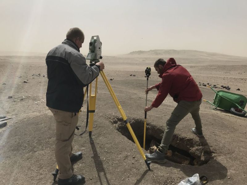
However, photographing, surveying and measuring under these conditions were really a challenge and Fabian and Max managed all what was possible (Fig. 1).
Fig. 1: Measuring outlines of stratigraphical units in the tomb at GiE 002 during heavy wind was anything else than easy or pleasant.
The results in this tomb (Fig. 2) are really amazing – we have found seven individuals so far and maybe more are to come!
Fig. 2: I hope to finally finish excavating this really intriguing tomb at GiE 002 in the upcoming days.
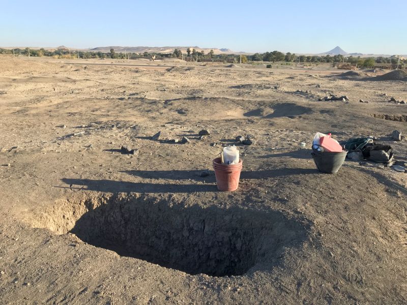
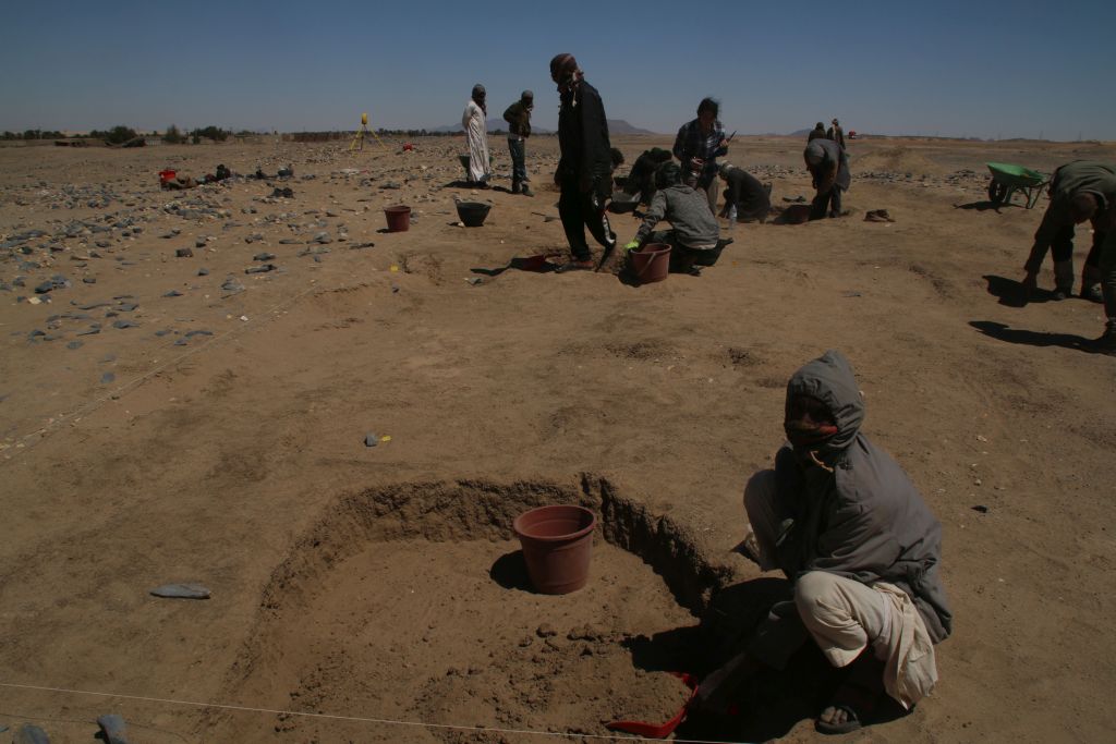
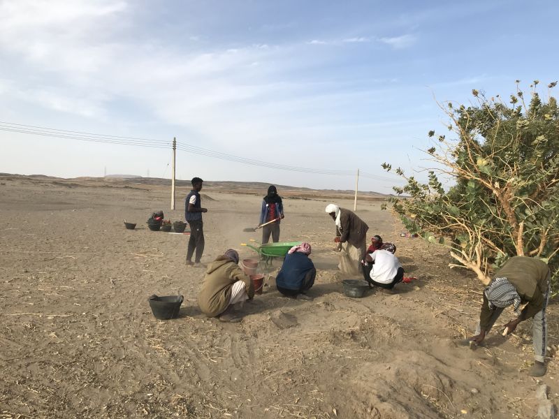
Originally, week 2 of our spring season was supposed to focus on excavation in GIE 003, a large Kerma cemetery at Attab/Ginis East. Here, we opened two trenches. In both of them, we found several burial pits and features filled with sand and human bones just below the surface, originally covered by tumulus superstructures. Excavation of these pits started on Thursday (Fig. 3) and although all is plundered, the material culture is really illustrative – high quality Kerma Classique ceramic vessels, Egyptian Marl clay vessels and some various types of beads as well as a pendant made of a mollusc. We are all very much looking forward to the next week!
Fig. 3: Excavations at the Kerma cemetery are now finally progressing fine!
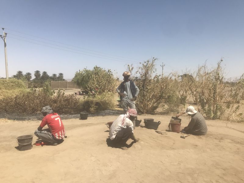
In week 2, we were joined by late-comers from Munich and the 2022 field team is now complete: Together with Iulia, Sawyer helps with various tasks in the field and both of our student assistants were also drawing pottery during the very windy days; Rennan is excavating in the Kerma cemetery and Cajetan is using our drone for making aerial photographs.
Internet connection was and still is really unstable here at Ginis and more than updates on our weekend is difficult – so I hope to get your again interested next Friday!
Week 2 was very dense – we had strong winds on several days, even had to stop work on Monday and Tuesday. While the team and the workmen moved on Sunday to Kerma cemetery GiE 003, I was staying with two workmen at one of the tombs we found at GiE 002.
* Please note: since we are excavating tombs, this blog post includes pictures of human remains.
The first tomb we found in Trench 1 was just a simple pit burial of probably Prenapatan or Napatan date. A minimum of 2 adult burials was found, but all mixed and displaced.
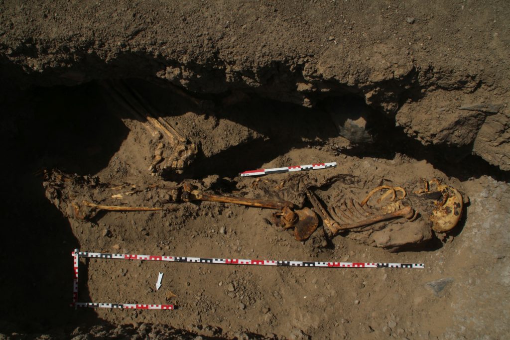
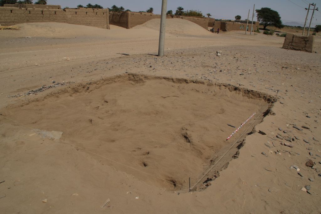
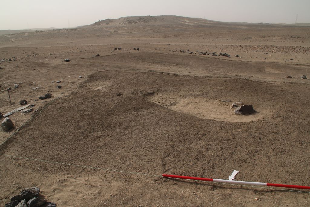
The other tomb in Trench 4 (Fig. 1) was really quite surprising: an intact burial, wrapped in textiles from the head to the feet was found in an extended sidewards position in the sandy filling (Fig. 2). A few mud bricks were found along the body, the back part of the neck was resting on a large mud brick. This female burial seems to date from Medieval times (a completely wrapped body of this period was found by Vila in a cemetery nearby in Ginis, at 3-P-37, see Vila 1977: 98-101, Fig. 44) and is of intrusive character.
Fig. 1 – The tomb in Trench 4 with the outline of the pit and its sandy filling.Fig. 2 – The intrusive (seemingly Medieval) burial in the pit.
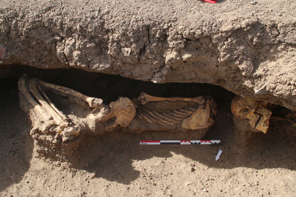
The same holds true for two (or maybe even three) individuals discovered slightly above the Medieval burial in the side niche of the tomb. One well preserved burial in a contracted position and one skull with remains of the shoulders was unearthed (Fig. 3). Another skull probably belongs to the contracted burial, but was slightly displaced. This requires an expert check by a physical anthropologist.
Fig. 3 – The contracted burial and another intrusive skull in the side niche.
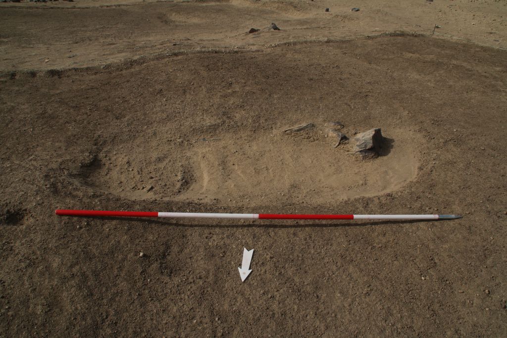
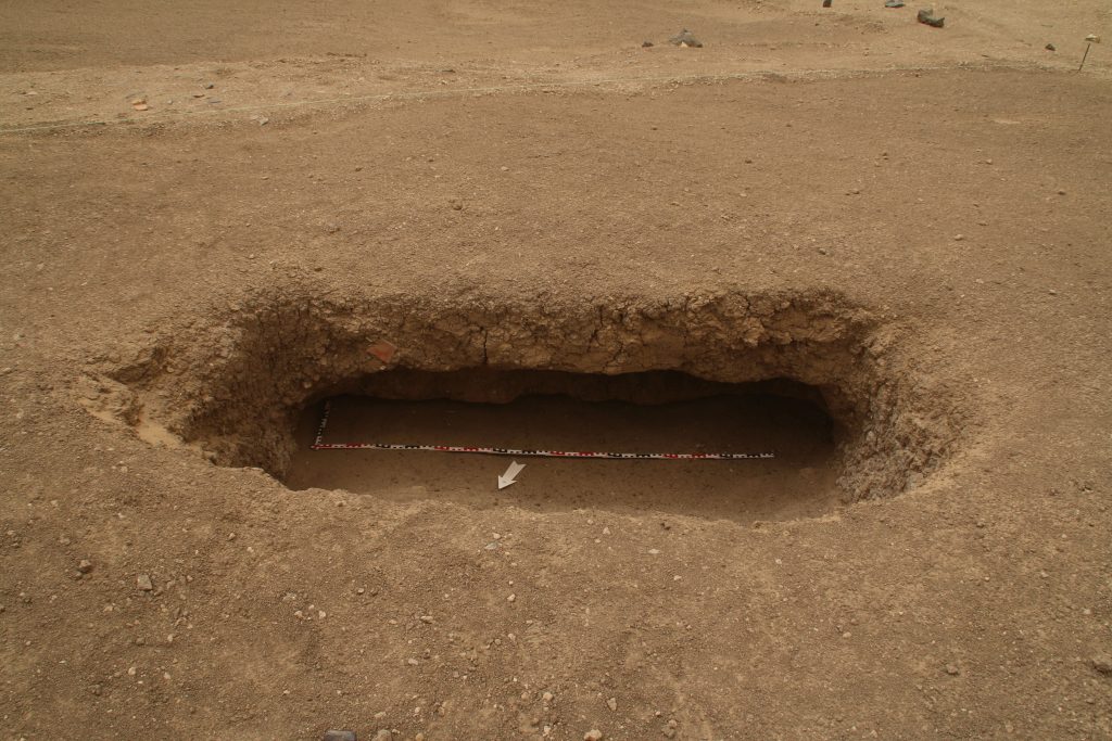
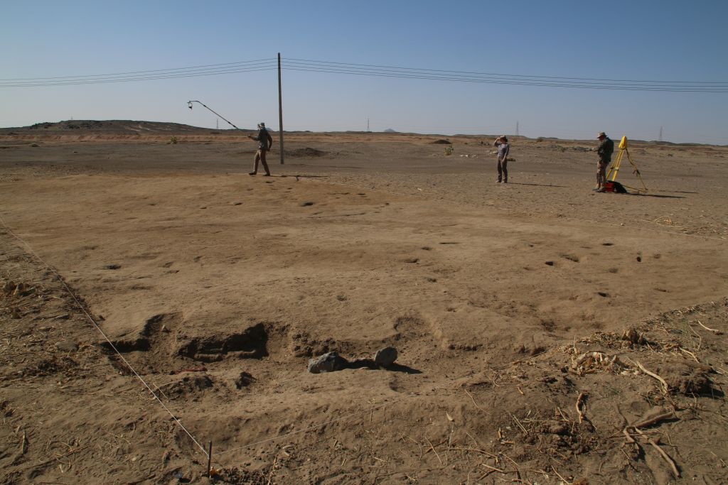
Apart from some Prenapatan (or maybe Napatan) sherds in the filling, no finds were made so far. My assumption is that the niche will continue as a proper side chamber to the south (see Fig. 4) and that we will find remains of the original burials in a lower depth. Let’s see if this expectation comes true! Already now, our findings in GiE 002 differ from the results by Vila and suggest a very interesting long use-life of this cemetery with multiple burials from various periods.
Fig. 4 – The status of the tomb with the upper burials removed – the side niche seems to continue towards the south.
Reference
Vila 1977 = A. Vila, La prospection archéologique de la Vallée du Nil, au Sud de la Cataracte de Dal (Nubie Soudanaise). Fascicule 5: Le district de Ginis, Est et Ouest. Paris 1977.
We had an early and unpleasant start into the weekend – because of a strong sandstorm we needed to stop work at Thursday already before breakfast. Since we were just cleaning the human remains in the first tomb we found at GiE 002 and discovered a second pit burial, this was indeed unfortunate.
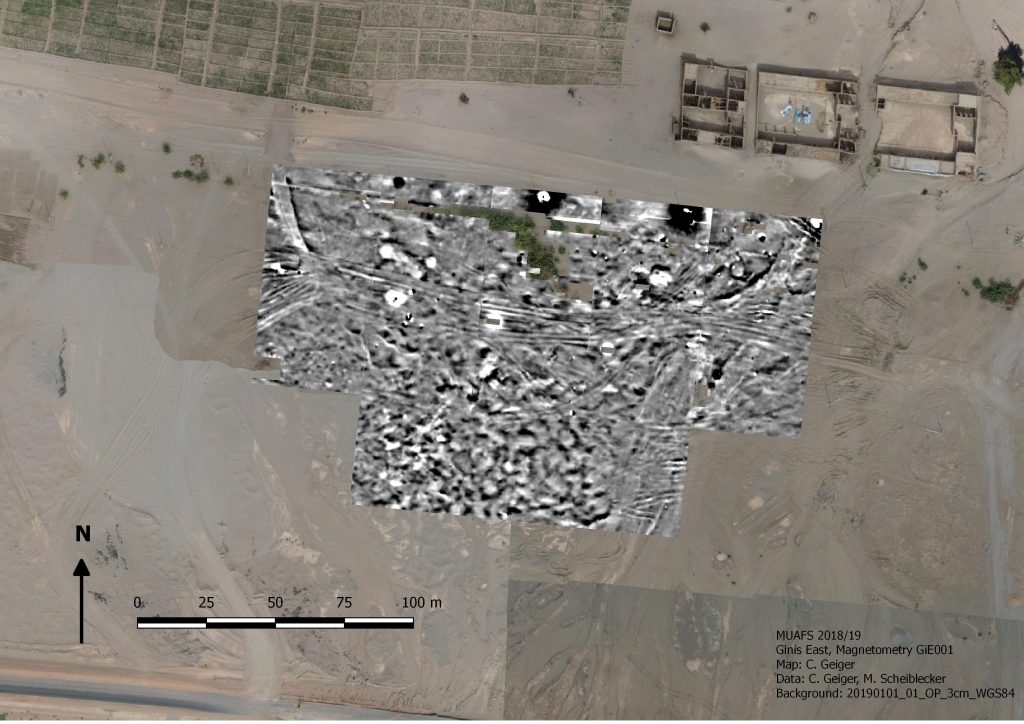
However, the first week of our 2022 was intense and in many respects successful. Part of this success might not seem very positive at the first glance, but is nevertheless of much relevance for the project. We stopped work at the settlement site GiE 001 already after 4 days. We did not succeeded in finding archaeological features at this site, but we confirmed my earlier impression about this site based on the results from the two test trenches we opened in 2020 (Trench 1 and 2`, Budka 2020, 66-67). With one large area (Fig. 1) and one small test trench (Fig. 2) we now know for sure that a thin sandy surface layer with finds from various periods – Kerma, 18th Dynasty, Ramesside, Napatan and Medieval – is directly on top of natural alluvial layers. No archaeological stratigraphy or sediments are preserved. Our magnetometry from 2018/2019 does not show any archaeological features but simply differences in the soil (e.g. sandy areas).
Fig. 1: Trench 3 at GiE 001 which did not yield any archaeological layers other than the top soil mixed with finds.Fig. 2: Trench 4 where the natural surface was just covered by a sandy top layer comprising much pottery and stone tools (mixed date).
With this confirmed, we moved on Wednesday to cemetery GIE 002 just a bit further south. Here, the main aim was finding some tombs to check the dating as proposed by Vila in the 1970s. He dated the small cemetery with largely dismantled stone superstructures to the New Kingdom, but already the one pit burial he excavated and its pottery vessels suggest that this is too early. A Pre-Napatan or Napatan dating would clearly fit much better.
This is now getting more and more likely after just 1.5 days of work – we discovered two tombs of the pit burial type as described by Vila (site 2-T-13) and all of the associated ceramics seem to postdate the New Kingdom.
First, we opened a large area where we thought depressions of three tombs are visible on the surface (and on the magnetometry, Fig. 3). The result was a bit surprising, only one tomb in the eastern part was found (Fig. 4).
Fig. 3: Location of Trench 1 at GiE 002.Fig. 4: the burial pit in Trench 1 found refilled by windblown sand.
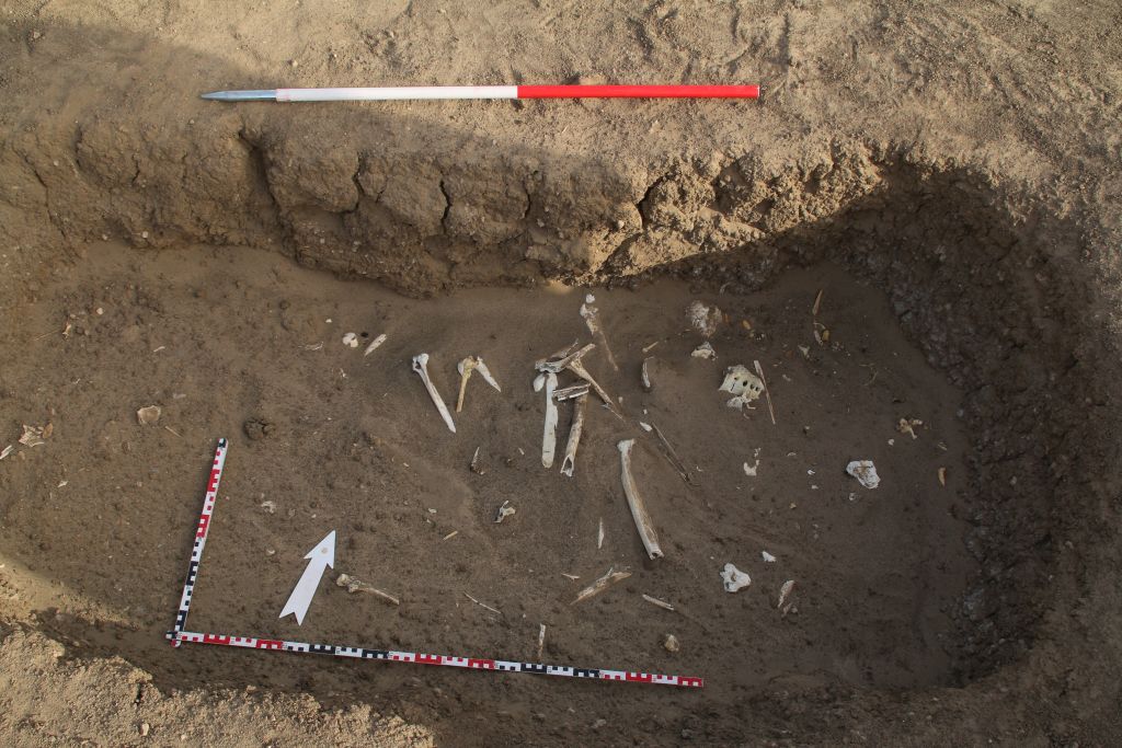
In the sandy filling of this burial pit, we have a minimum of one adult burial in displaced position (Fig. 5). Because of the sandstorm, we did not yet finish excavations and still need to clean the pit. Since Vila found the remains of seven individuals in a similar burial pit (Vila 1977, 48, fig. 16), I expect more human remains closer to the bottom.
Fig. 5: the pit burial yielded displaced human remains within the sandy filling.
Two other areas in GiE 002 yielded no burials at all, but Trench 4 finally comprised another pit burial filled with windblown sand (Fig. 6). We also started work in another area (Trench 5) but had to stop there because of the storm. Thus, with a minimum of two pit burials to be excavated we will be able to reassess this site – please keep your fingers crossed that the tombs also include some diagnostic pottery!
Fig. 6: the newly discovered burial pit before we needed to stop because of the storm.
In our first week, the division of work within the team worked out perfectly. Max and Fabian from Novetus were documenting all trenches at GiE 001 and GiE 002, Iulia was responsible for writing find labels and the consecutive find list. Our inspector Huda helped with supervising the workmen and our driver Imad was helpful in many respects. All of them, our wonderful gang of Sudanese workmen included, did a great job and I am very much looking forward to the results of the upcoming week.
References
Budka 2020 =J. Budka, Kerma presence at Ginis East: the 2020 season of the Munich University Attab to Ferka Survey Project, Sudan & Nubia 24, 2020, 57-71.
Vila 1977 = A. Vila, La prospection archéologique de la Vallée du Nil, au Sud de la Cataracte de Dal (Nubie Soudanaise). Fascicule 5: Le district de Ginis, Est et Ouest. Paris 1977.
Time flies by, especially in the field. We have been really busy since our arrival at Ginis on Thursday. Apart from logistics and last constructions in the new digging house, we prepared the start of fieldwork at the New Kingdom site of GiE 001. I am delighted that new team members have arrived at Ginis: This season, the LMU DiverseNile team is strengthened by two employees of Novetus (Vienna). Maximilian Bergner and Fabian Spitaler are both experienced field archaeologists and responsible for the excavation work and field documentation in this 2022 season.
On Saturday, we opened a large new trench and started excavations with a team of local workmen. We placed the trench based on the results from the magnetometer survey in 2018/2019 and of course the local topography.
Start of work at Trench 3 on Saturday.
On our second day, we are currently still removing surface layers of sand and soft mud levels – the area used to be a favourite resting place for one of the sheep herds of Ginis (and the animals still have plenty opportunities just a bit further to the east and fortunately quickly adapted to this change in their daily routine). This is evident by many droppings and darkened spots on the surface.
Most of the trench is covered by loose sand below the uppermost surface (photo: I. Comsa).Imaged based documentation of the individual stratigraphical units in the new trench.
Nevertheless, already in the uppermost layers we are finding plenty of New Kingdom pottery. I processed the first baskets from these layers this afternoon. Interestingly, some contexts produced more Nubian style pottery than Egyptian style pottery – maybe this is just accidental, but the occurrence of Black-Topped Kerma style wares as well as impressed and incised decorated Nubian wares and basketry impressed cooking pots are intriguing. As documented earlier, I am also stunned by the fact that both 18th Dynasty and Ramesside pottery is present, suggesting a long period of use of this settlement.
Work will continue tomorrow and we will try to keep you posted – internet connection is very unstable at our digging house in Ginis, but the connection in the town of Abri allows me to upload small data like this blog post.
After some really busy and intense weeks, I finally made it back to Sudan. Iulia and I arrived yesterday night. Everything is sorted and we are ready to leave Khartoum to the north tomorrow morning with our friend and colleague Huda as our NCAM inspector – to start our first proper excavation season for the ERC DiverseNile project.
This spring season is super exciting: we will excavate several New Kingdom sites at Ginis East, hopefully also on the West bank. Other than in our test excavations in 2020, we will open large areas and conduct our excavation work with the help of local workmen. Starting on Saturday with site GiE 001, we will test once more the results of the magnetometry from 2018/2019.
Fig. 1: results of magnetometry of GiE 001 2018/2019 and its sourroundings (M. Scheiblecker).
This season is also exciting because we will live for the first time in the new digging house in Ginis East. Construction work started in January and has been finished just in time, allowing us to settle down in our new home away from home during these weeks in northern Sudan. I am very much looking forward to this!
Excavations are scheduled for 4 weeks, with an extra week for processing and/or survey, depending on our results. Of course I will keep you updated – hoping that internet connection will allow to do so.
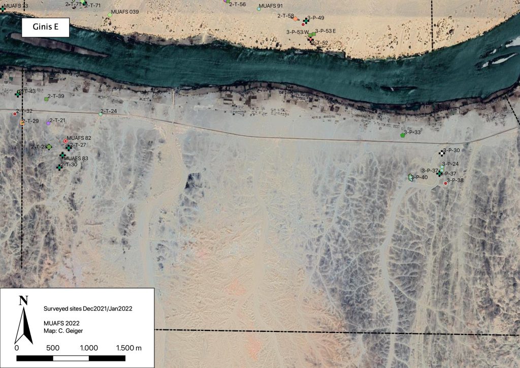
During our short season in December 2021/January 2022, we were able to record 14 sites on the East bank of the district of Ginis. These are 12 sites previously recorded by Vila as well as two new MUAFS sites (Fig. 1).
Fig. 1: Recorded sites in Ginis East, Dec. 2021/Jan. 2022. Map: C. Geiger.
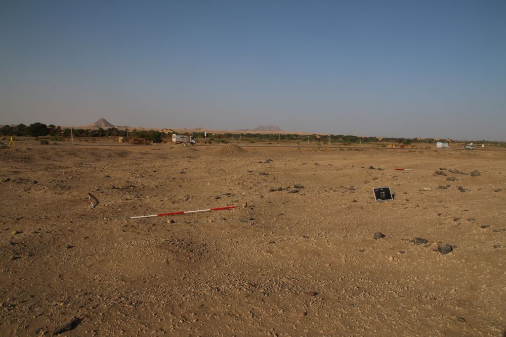
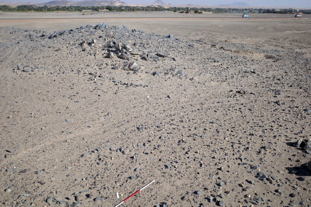
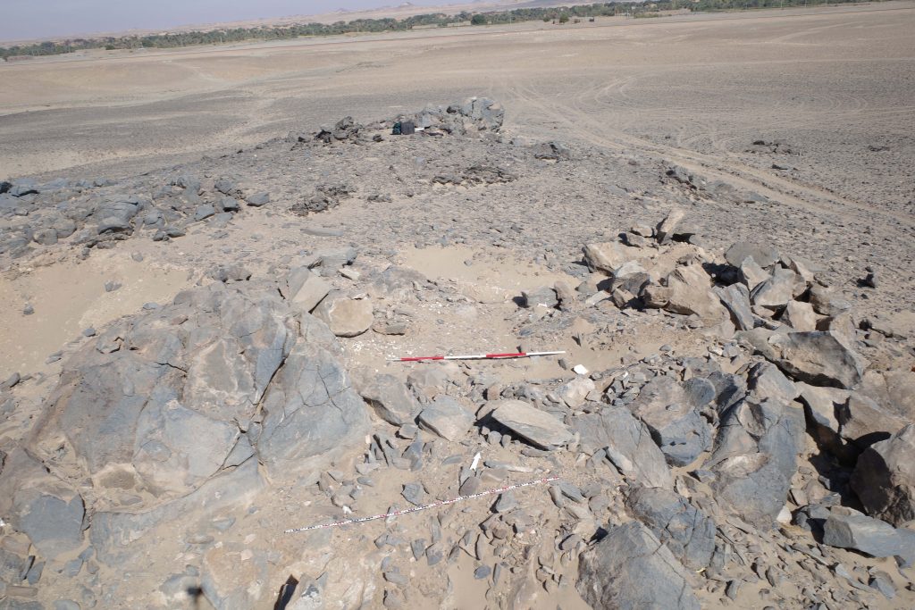
One particularly noteworthy site is the Abkan occupation site 2-T-21 at Ginis East, on a hill above the modern asphalt road (Fig. 2). According to the current chronologies, the Abkan period is dated to between c. 5500 and 3700 cal BCE (see D’Ercole 2021 with discussion and references).
Fig. 2: Overview of site 2-T-21. Photo: J. Budka.
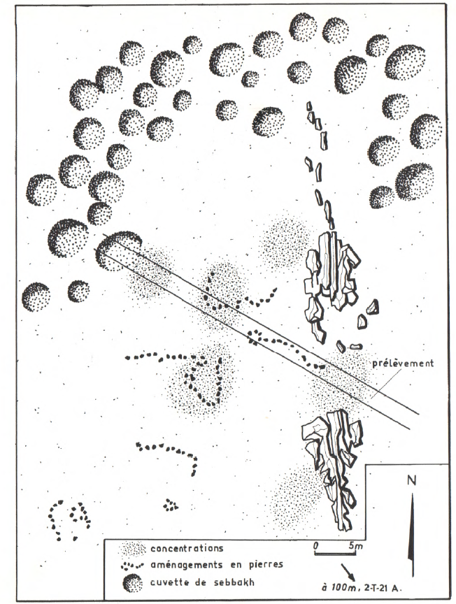
We could note that the meticulous documentation by Vila (1977) for 2-T-21 was correct (Fig. 3). Many diagnostic pottery sherds are still scattered on the surface. This site is clearly worth a more detailed investigation, although it has recently suffered from modern destruction like car tracks running through the site.
Vila’s sketch map of site 2-T-21 (Vila 1977, 60, Fig. 23).
Significant traces of Abkan occupation were recently documented by Elena Garcea on the island of Sai (Garcea 2020, 50 and 94 with references). The contemporaneous sites in our concession, of which several were documented on both riverbanks in Attab and Ginis, hold much potential and have received until now only little attention. Especially the relations of the Neolithic Abkan sites to Khartoum Variant sites in the region between the Dal Cataract and Sai Island needs to be explored in detail, not only regarding the chronology and possible overlaps but also in terms of subsistence strategies of these prehistoric communities as semi-sedentary hunter-gatherers and/or herding groups. This ties in with general questions about changes in the settlement strategies by Mesolithic groups compared to Neolithic communities (see D’Ercole 2021). Furthermore, until today, no cemeteries of the Abkan cultural complex have been identified – a highly unusual feature for a Neolithic culture in Sudan and something worth investigating in the future. Maybe the region between Attab and Ferka will provide some answers in this respect.
References
D’Ercole, G. 2021. Seventy Years of Pottery Studies in the Archaeology of Mesolithic and Neolithic Sudan. Afr Archaeol Rev 38, 345–372. https://doi.org/10.1007/s10437-021-09432-y
Garcea, E. 2020. The Prehistory of the Sudan. Springers Briefs in Archaeology. Cham.
Vila, A. 1977. La prospection archéologique de la Vallée du Nil, au Sud de la Cataracte de Dal (Nubie Soudanaise). Fascicule 5: Le district de Ginis, Est et Ouest. Paris.
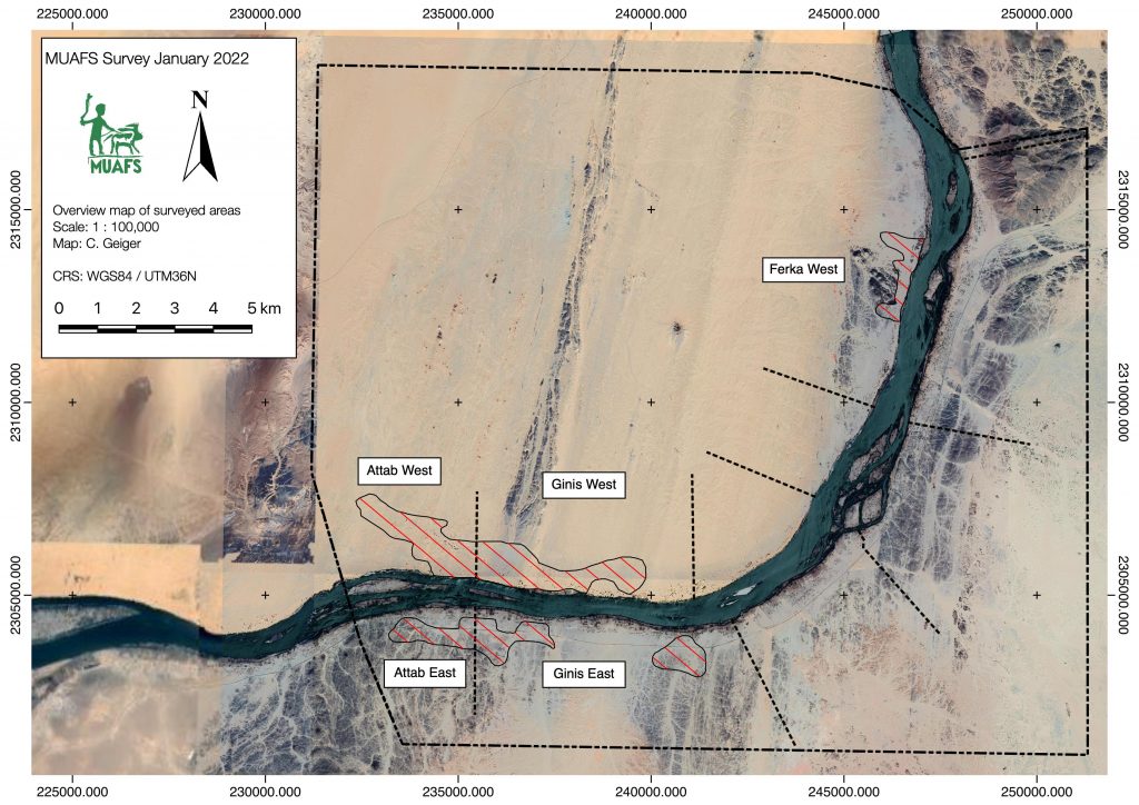
We have returned safely from Sudan and our short preparation season of the Munich University Attab to Ferka Survey Project (MUAFS) in its research concession between Attab and Ferka from Dec. 29 to January 9 was very successful.
Huda, our driver Saif and I getting ready to leave for another day of surveying the area (photo: C. Geiger).
Huda and I conducted a foot survey in areas of Attab East, Attab West, Ginis East, Ginis West and Ferka West. The focus was on the identification of sites already recorded by Vila. We were able to document a total of 79 sites, comprising 21 new MUAFS sites. The sites range in date from Palaeolithic times to the Medieval and Ottoman eras. The types of sites are mostly camp sites, habitations, and tombs/cemeteries, but also include rock art and stone wadi walls.
Surveyed area of the 2021/2022 season (map: C. Geiger).
Whenever possible, we collected diagnostic pottery and lithics from the sites for dating purposes. I was able to document most of them by photography and also managed to draw 35 Kerma and New Kingdom sherds. Most interesting are some newly documented New Kingdom sites, attesting to both a use in the 18th Dynasty and a Ramesside presence in the periphery of Amara West.
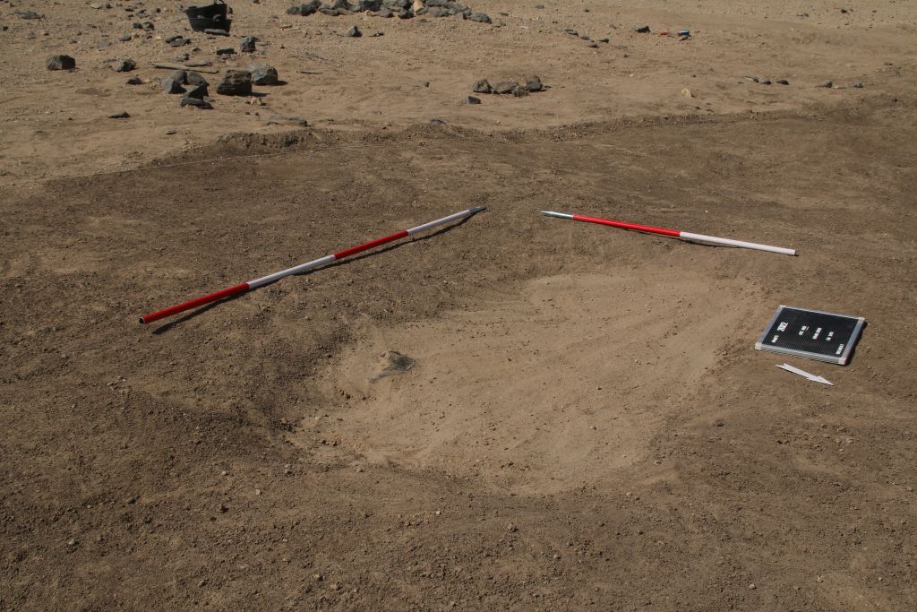
One example of a newly documented site, unfortunatly recently plundered (photo: J. Budka).
One particularly striking site, a cluster of cleft tombs at Ginis East, has never been documented before but was unfortunately lately plundered. And this is not an isolated example! Recent plundering, modern gold working, new electricity lines and damaged caused by car tracks, roads and new buildings are unfortunately very frequent, have increased since 2020 and stress how urgently we need to document this rich area in the Middle Nile.
The surveying campaign carried out by Cajetan resulted in the setup of new benchmarks using a GPS Antenna and a totalstation in Attab East, Ginis East and Ginis West. We will use these benchmarks as basis for future measurements during our planned excavations. Drone aerial photography was successfully conducted in Ginis East, Ginis West and Ferka West.
All in all, I am very grateful to the support of our Sudanese friends and colleagues – without them our work at site would not have been possible in these very difficult times of political changes. We collected a large amount of new data and will now be very busy processing these here in Munich – and of course we will keep you updated.
The Christmas weekend is just about to end, and I am currently packing my last suitcase – despite of omicron & the pandemic, but of course with much caution and aware of the most recent political developments in Sudan, we are getting ready to fly to Khartoum tomorrow.
It will be a very brief season with a tiny team – just Rennan, Cajetan and I will travel. One focus of our planned work is on the study & documentation of object’s stored in the Sudan National Museum, coming from Vila’s survey in the 1970s in the present MUAFS concession. Rennan will focus in particular on ceramics and small finds from some of the New Kingdom tombs. Especially Ramesside material is highly interesting and raises many questions concerning the continuity of sites in the pre-Napatan era.
Up in the north, at our excavation house in Ginis East, I will focus on some logistics, preparing the upcoming excavation season planned for spring 2022. I also plan some survey work with our inspector and Cajetan will concentrate on setting survey points and taking measurements.
Of course, we will keep you updated – maybe not during the season, depending on the quality of the internet and connection.
Hoping that most of our plans will work out, but also very much prepared for surprises and the need to improvise, I am just really very happy to be soon back in Sudan, after almost 2 years!
Before we’re able to go to the field, a lot of work on the cemeteries in our concession area is currently underway from Munich. Marion’s recent blog posts already discussed the potential of magnetometry for us to better understand what we are dealing with, and this is especially true in connection with Cajetan’s remote sensing work. Cajetan’s work has been revealing some interesting aspects of our sites and hopefully you’ll be able to catch glimpses of his work soon in here.
This work provides important background regarding the specificities of our sites. Alongside an assessment of the cemeteries and comparison with other sites across Nubia, this allows us to put together an ‚ideal type‘ (sensu Max Weber) that can guide us through future survey and excavation. The data sets produced by Vila, as well as previous MUAFS seasons, are also crucial for us to establish this ideal type, which works as a methodological tool to confirm our hypotheses (or not).
In my previous posts, I’ve already shared details about the assessment of sites I’ve been carrying out over the past months. Base on Vila’s data, we can know what to expect from the cemeteries in terms of preservation, types of structures etc. For example, the Late New Kingdom „tomb of Isis“ works an example of „elite“ or „sub-elite“ burial ground in the periphery of temple towns, where Egyptian and Nubian features mixed, probably to a greater extent than at temple towns—an example of hypothesis that we can create departing from an ideal type. This mixture occurred, for instance, in the combination of Egyptian substructures and a tumuli superstructure, remains of which were located in previous MUAFS seasons (see my previous posts). Departing from an ideal type such as the „tomb of Isis“ we can approach how the ideal varies across geographical and social spaces within our concession area.
For example, Marion and Cajetan’s work are shedding light on the extension of cemeteries where we can easily see from above those tumuli, some of which already explored by Vila, but also other features. It is difficult to determine from a distance what is the nature of this evidence. Comparative research then comes in handy. I’ve already proposed a discussion on the whereabouts of the majority of the Nubian population during the New Kingdom (a discussion that also applies to the Kerma period).
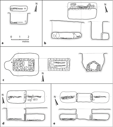
Figure 1: tomb types at Fadrus, adapted from Spence 2019, based on Säve-Söderbergh and Troy 1991.
Other Nubian cemeteries such as Fadrus in Lower Nubia add information about non-elite groups to our ideal type (figure 1). If larger tumuli such as the „tomb of Isis“ are easily located based on drone and satellite imagery, simple non-elite pit graves originally with no extensive superstructures pose more challenges. Though, comparisons allow us to open up to possibilities that include, in our research framework, social groups not clearly represented by evidence accumulated from large temple-town cemeteries. These groups—which comprised the bulk of Nubian populations working in the fields, mines, and probably carrying out other work in the service of larger centres—are yet to be fully understood (and here work at the cemeteries of Amarna provide us interesting comparison points, see Stevens 2018).
Several are the challenges of doing research from the office, as we cannot yet go to the field. But work conducted so far, from various fronts, help us establish a pretty solid starting point from which to explore our sites knowing more or less what to expect. This takes into account old and new evidence, extensive comparisons with other sites and a clear theoretical framework, which is essential to formulate research questions and carry out large scale projects such as DiverseNile.
References
Säve-Söderbergh and Troy 1991. New Kingdom pharaonic sites: the finds and the sites.
Spence 2019. New Kingdom burials in Lower and Upper Nubia. In Handbook of Ancient Nubia, ed. D. Raue.
Stevens 2018. Death and the city: The cemeteries of Amarna in their urban context. Cambridge Archaeological Journal 28 (1): 103–126. doi:10.1017/S0959774317000592
The magnetic data collected at our first campaign in the Attab to Ferka region in 2018/2019 was first processed and interpreted directly after the field season. After the first excavation campaign in 2020, focusing on two of the four geophysically investigated sites, a reconsideration of the data took place. It is based on the excavation results, the photogrammetric data and new kite images.
But before looking at the data, you have to know where exactly on earth the data was generated! The Earth’s magnetic field is a complex system, which is protecting us against ultraviolet radiation, as it is deflecting most of the solar wind, which is stripping away the ozone layer. The earth’s magnetic field can be visualized as a three-dimensional vector: Declination (angle in ° to geographic north, X), Inclination (horizontal angle in ° or magnetic dip, Y) and Intensity (measured in T “Tesla” resp. nT “Nanotesla”, Z). In archaeomagnetism, all components are measured to be compared to the single curves of the region. For magnetometry and interpreting these data, the Inclination is the most important value besides the Declination, which helps for example to detect in situ burnt features. The Inclination describes the angle in which the Earth’s Magnetic Field meets the surface of the Earth itself. Therefore, the angle is changing depending on your position e. g. if you are closer to the magnetic poles or to the magnetic equator.
The geomagnetic field changes all the time, every second, every day, and every year! For Munich resp. Fürstenfeldbruck you can follow the alterations simultaneously here. The geomagnetic observatory there is part of the Ludwig-Maximilians-Universität and the Department of Earth and Environmental Studies. As you may know, the magnetic poles are wandering as well. The magnetic north pole did it that fast in the last years that the navigation map had to be changed before the standard interval of five years in 2019. This world magnetic model (WMM) is available online.
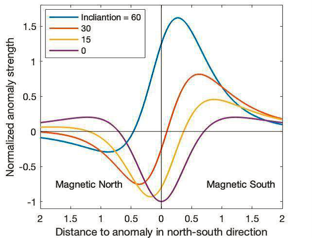
But why do we have to know especially the Inclination of the area we are working in and doing magnetometry? The shape and intensity of every single anomaly is depending especially on the Inclination! The shallower the Inclination the wider the anomaly is visible in the magnetogram. Additionally, the dipole (positive/black – negative/white) components are changing. The closer we are measuring to the geomagnetic equator (not the geographic equator), the larger gets the negative part of the anomaly and the lower are the amplitudes of the magnetic signal. Figure 1 illustrates the differences in Inclination for a single anomaly.
Figure 1: Anomaly strength of the total field intensity as north-south traverse through the anomaly’s centre for different Inclinations (Ostner et al. 2019, 181 Fig. 2).
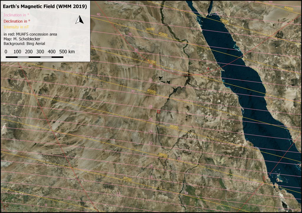
While the Inclination in Munich is around 64°, the Inclination in the MUAFS concession area is 27-28° and shallower. The components of the Earth’s Magnetic Field at the MUAFS concession area are illustrated in Figure 2, showing a Declination of almost 4° and a total field intensity of around 39.000 nT (Munich: 48.585 nT). The measured archaeological and geological features, visible in the magnetogram, are showing contrasts of sometimes less than 1 nT. Due to different Inclinations, the same archaeological feature would result in a different anomaly in Sudan compared to Munich. While the anomaly in Sudan would be wider (see the red curve, Fig. 1) than in Munich (ca. the blue curve, Fig. 1), it would cause lower intensities as well as showing more negative parts than the Munich one. This means while in Bavaria the negative part of an anomaly is regarded more as a small “white shadow”, in Sudan it would be almost equal to the positive part of the anomaly. Furthermore, depending on the depth of the buried feature, the shift in locating the feature could be larger with shallower inclination.
Figure 2: The Earth’s Magnetic Field in Sudan after World Magnetic Model (WMM) 2019, with the MUAFS concession area in red (M. Scheiblecker).
Regarding the used magnetometer – a gradiometer, the intensities are additionally lower than for example with a total field magnetometer, which makes it more difficult to interpret the data and why sometimes low value-features like pisé walls are not detectable with gradiometers. Furthermore, with wider anomalies closer to the geomagnetic equator like in Sudan, it is more possible that anomalies are overlapping so that it is not easy to distinguish features lying next to each other or from different periods.
Usually, magnetograms are shown in greyscale to avoid confusion and “pseudo-limitations” of different values and colors. For interpreting the data, one can play around with the minimum and maximum values as well as inverting of the greyscale version. On magnetograms of measurements with the total field magnetometer usually a high-pass filter is applied, which can be overlayed with the total field data as well.
In rare cases it is helpful to use color scales for the magnetograms additionally to show special features better or to highlight some very high or low values. If the magnetogram is disturbed by high magnetic anomalies like metal fences, iron rubbish on the site etc., color scales are not useful anymore, because they are showing especially the disturbances due to their high amplitudes and less of the archaeological features itself. Nevertheless, it is possible to adjust the color scale as needed for every site separately.
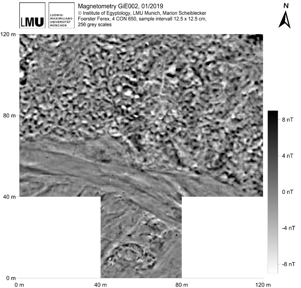
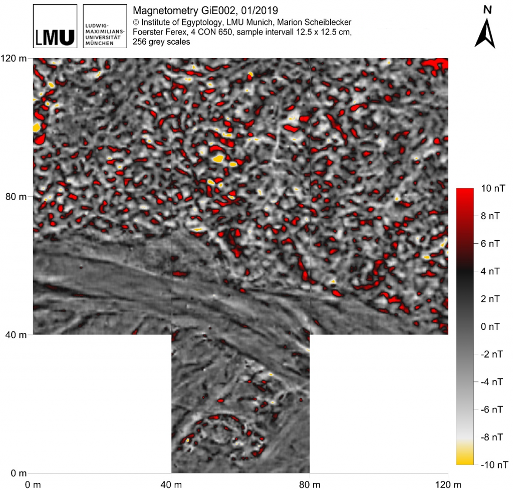
Illustrating the mentioned methods, I would like to show the magnetogram of GiE 002, where a cemetery is located.
Figure 3: Magnetogram of GiE 002 in greyscale (M. Scheiblecker).
The usual greyscale (Fig. 3) shows clearly the traces of the recent and former wadi/khor, tumuli-like features in the very south as well as lots of features of different shape in the northern part of the magnetogram, interpreted as graves. They are resulting in positive anomalies, accompanied by negative anomalies of different amplitudes.
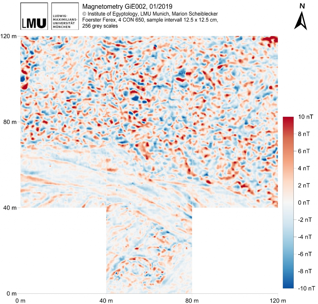
Figure 4: Magnetogram of GiE 002 in blue to red color scale (M. Scheiblecker).
To understand more of the single burials it is helpful to change to a blue-red color scale (Fig. 4). In this way, it is easier to differentiate the single anomalies consisting of the positive (red) and negative (blue) part.
Figure 5: Magnetogram of GiE 002 in highlighted grey scale, showing maximum values in red as well as minimum values in yellow (M. Scheiblecker).
Highlighting the minimum and maximum values – in yellow resp. red – helps e. g. focusing on the probably best-preserved archaeological features located in the center of the measured area, visible in Figure 5.
The magnetograms of GiE 002 show clearly that it is worth playing around with different color scales and that there is more than one magnetogram important for interpreting the data for archaeological and geological purposes.
References
Fassbinder, J. W. E. (2017): Magnetometry for Archaeology. In: Allan S. Gilbert, Paul Goldberg, Vance T. Holliday, Rolfe D. Mandel and Robert Siegmund Sternberg (eds.): Encyclopedia of Geoarchaeology. Dordrecht: Springer Reference (Encyclopedia of Earth Sciences Series), 499-514.
Livermore, P.W.; Finlay, C.C.; Bayliff, M. (2020): Recent north magnetic pole acceleration towards Siberia caused by flux lobe elongation. Nature Geoscience 13, 387–391.
Ostner, S.; Fassbinder, J. W. E.; Parsi, M.; Gerlach, I.; Japp, S. (2019): Magnetic prospection close to the magnetic equator: Case studies in the Tigray plateau of Aksum and Yeha, Ethiopia. In: James Bonsall (ed.): New Global Perspectives on Archaeological Prospection. 13th International Conference on Archaeological Prospection. 28 August – 1 September 2019. Sligo – Ireland. Oxford: Archaeopress, 180-183.