We had an early and unpleasant start into the weekend – because of a strong sandstorm we needed to stop work at Thursday already before breakfast. Since we were just cleaning the human remains in the first tomb we found at GiE 002 and discovered a second pit burial, this was indeed unfortunate.
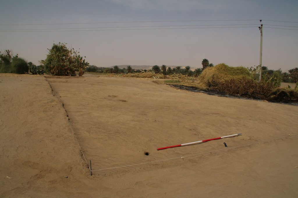
However, the first week of our 2022 was intense and in many respects successful. Part of this success might not seem very positive at the first glance, but is nevertheless of much relevance for the project. We stopped work at the settlement site GiE 001 already after 4 days. We did not succeeded in finding archaeological features at this site, but we confirmed my earlier impression about this site based on the results from the two test trenches we opened in 2020 (Trench 1 and 2`, Budka 2020, 66-67). With one large area (Fig. 1) and one small test trench (Fig. 2) we now know for sure that a thin sandy surface layer with finds from various periods – Kerma, 18th Dynasty, Ramesside, Napatan and Medieval – is directly on top of natural alluvial layers. No archaeological stratigraphy or sediments are preserved. Our magnetometry from 2018/2019 does not show any archaeological features but simply differences in the soil (e.g. sandy areas).
Fig. 1: Trench 3 at GiE 001 which did not yield any archaeological layers other than the top soil mixed with finds.Fig. 2: Trench 4 where the natural surface was just covered by a sandy top layer comprising much pottery and stone tools (mixed date).
With this confirmed, we moved on Wednesday to cemetery GIE 002 just a bit further south. Here, the main aim was finding some tombs to check the dating as proposed by Vila in the 1970s. He dated the small cemetery with largely dismantled stone superstructures to the New Kingdom, but already the one pit burial he excavated and its pottery vessels suggest that this is too early. A Pre-Napatan or Napatan dating would clearly fit much better.
This is now getting more and more likely after just 1.5 days of work – we discovered two tombs of the pit burial type as described by Vila (site 2-T-13) and all of the associated ceramics seem to postdate the New Kingdom.
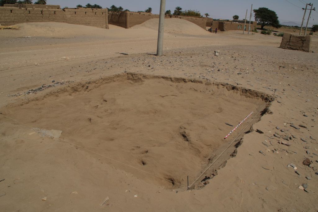
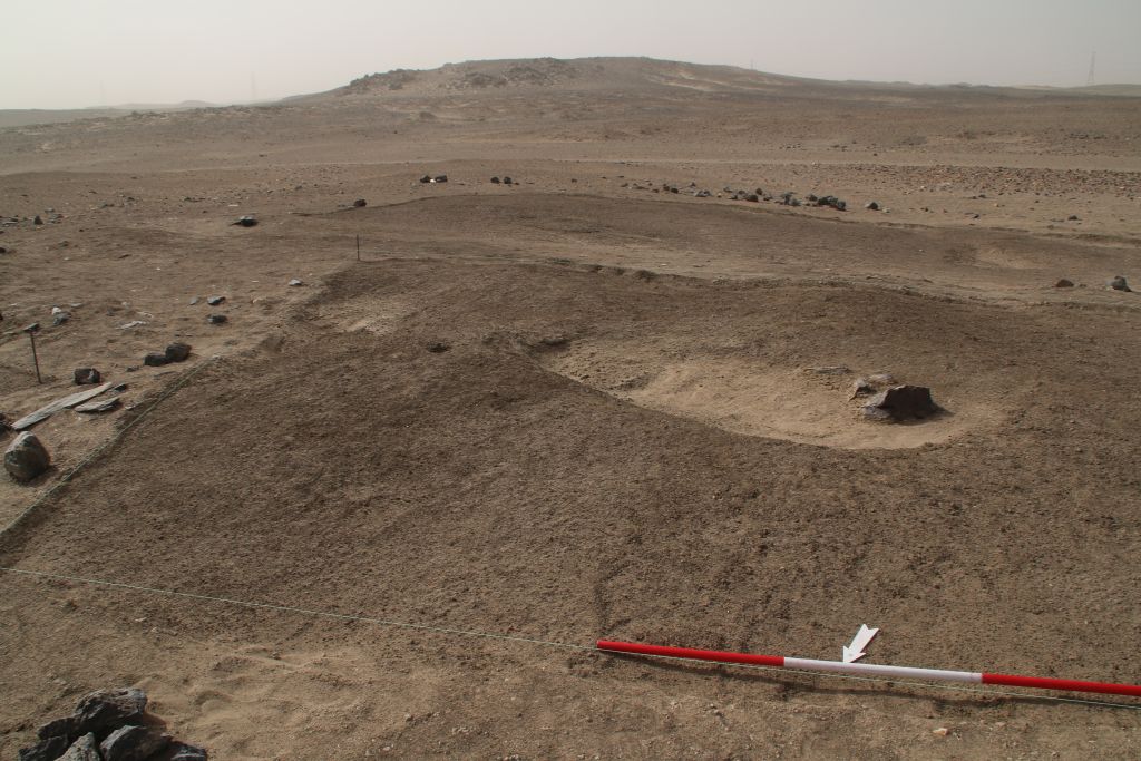
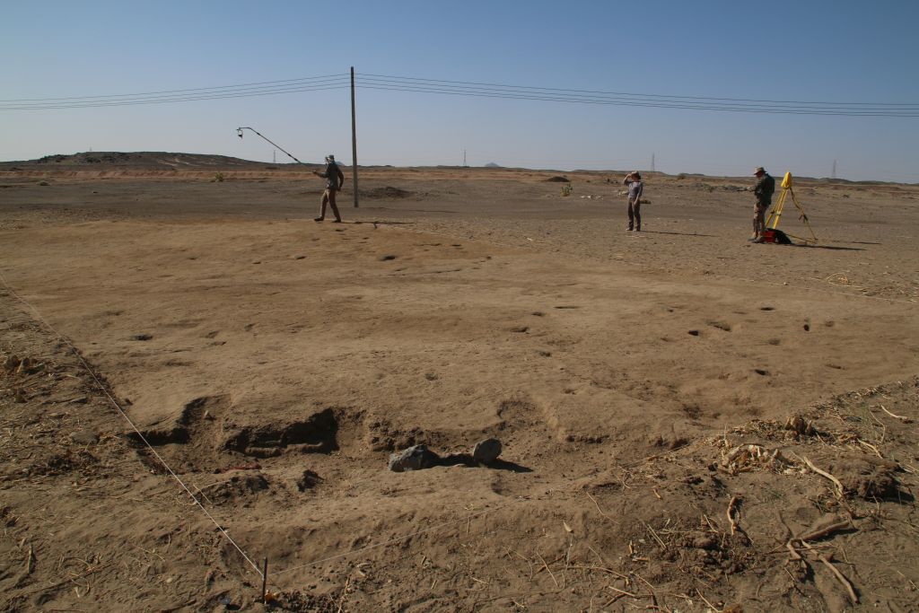
First, we opened a large area where we thought depressions of three tombs are visible on the surface (and on the magnetometry, Fig. 3). The result was a bit surprising, only one tomb in the eastern part was found (Fig. 4).
Fig. 3: Location of Trench 1 at GiE 002.Fig. 4: the burial pit in Trench 1 found refilled by windblown sand.
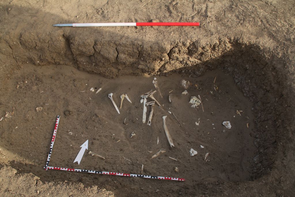
In the sandy filling of this burial pit, we have a minimum of one adult burial in displaced position (Fig. 5). Because of the sandstorm, we did not yet finish excavations and still need to clean the pit. Since Vila found the remains of seven individuals in a similar burial pit (Vila 1977, 48, fig. 16), I expect more human remains closer to the bottom.
Fig. 5: the pit burial yielded displaced human remains within the sandy filling.
Two other areas in GiE 002 yielded no burials at all, but Trench 4 finally comprised another pit burial filled with windblown sand (Fig. 6). We also started work in another area (Trench 5) but had to stop there because of the storm. Thus, with a minimum of two pit burials to be excavated we will be able to reassess this site – please keep your fingers crossed that the tombs also include some diagnostic pottery!
Fig. 6: the newly discovered burial pit before we needed to stop because of the storm.
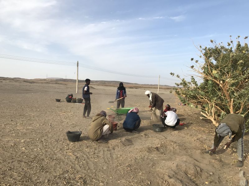
In our first week, the division of work within the team worked out perfectly. Max and Fabian from Novetus were documenting all trenches at GiE 001 and GiE 002, Iulia was responsible for writing find labels and the consecutive find list. Our inspector Huda helped with supervising the workmen and our driver Imad was helpful in many respects. All of them, our wonderful gang of Sudanese workmen included, did a great job and I am very much looking forward to the results of the upcoming week.
References
Budka 2020 =J. Budka, Kerma presence at Ginis East: the 2020 season of the Munich University Attab to Ferka Survey Project, Sudan & Nubia 24, 2020, 57-71.
Vila 1977 = A. Vila, La prospection archéologique de la Vallée du Nil, au Sud de la Cataracte de Dal (Nubie Soudanaise). Fascicule 5: Le district de Ginis, Est et Ouest. Paris 1977.
Time flies by, especially in the field. We have been really busy since our arrival at Ginis on Thursday. Apart from logistics and last constructions in the new digging house, we prepared the start of fieldwork at the New Kingdom site of GiE 001. I am delighted that new team members have arrived at Ginis: This season, the LMU DiverseNile team is strengthened by two employees of Novetus (Vienna). Maximilian Bergner and Fabian Spitaler are both experienced field archaeologists and responsible for the excavation work and field documentation in this 2022 season.
On Saturday, we opened a large new trench and started excavations with a team of local workmen. We placed the trench based on the results from the magnetometer survey in 2018/2019 and of course the local topography.
Start of work at Trench 3 on Saturday.
On our second day, we are currently still removing surface layers of sand and soft mud levels – the area used to be a favourite resting place for one of the sheep herds of Ginis (and the animals still have plenty opportunities just a bit further to the east and fortunately quickly adapted to this change in their daily routine). This is evident by many droppings and darkened spots on the surface.
Most of the trench is covered by loose sand below the uppermost surface (photo: I. Comsa).Imaged based documentation of the individual stratigraphical units in the new trench.
Nevertheless, already in the uppermost layers we are finding plenty of New Kingdom pottery. I processed the first baskets from these layers this afternoon. Interestingly, some contexts produced more Nubian style pottery than Egyptian style pottery – maybe this is just accidental, but the occurrence of Black-Topped Kerma style wares as well as impressed and incised decorated Nubian wares and basketry impressed cooking pots are intriguing. As documented earlier, I am also stunned by the fact that both 18th Dynasty and Ramesside pottery is present, suggesting a long period of use of this settlement.
Work will continue tomorrow and we will try to keep you posted – internet connection is very unstable at our digging house in Ginis, but the connection in the town of Abri allows me to upload small data like this blog post.
In my latest blog post, I discussed how to read magnetograms and what we have to keep in mind regarding the Earth’s Magnetic Field and the location of the concerning site. Another important factor to approach the comprehensive interpretation of our data is the environment, esp. the geology, geomorphology and formation processes of the region. For magnetometry, it is especially the knowledge about magnetic properties (ferromagnetism) of rocks, minerals and soils.
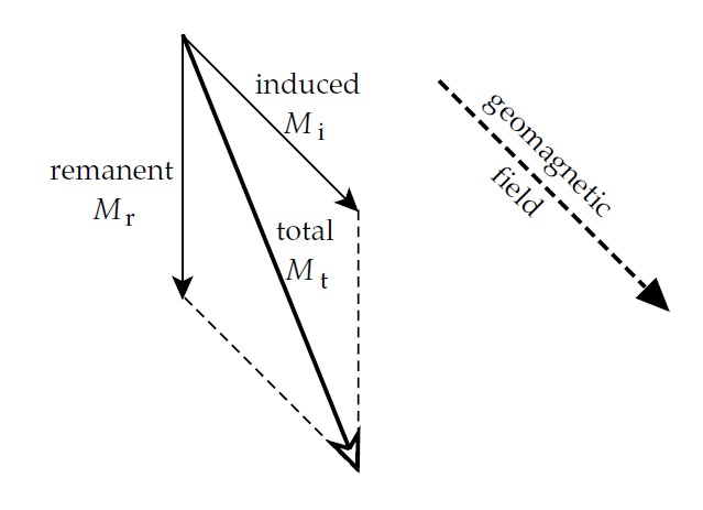
The magnetogram shows the total magnetization, which is composed by the induced and the remanent magnetization (Fig. 1). The relation of induced and remanent magnetization is described by the Koenigsberger ratio (Q-ratio). It informs us not only about the quality of the rock sample for paleomagnetism, but also if we are dealing with archaeological objects.
Figure 1: Magnetization for rocks with induced and remanent amounts (Lowrie 2007, 321 fig. 5.40 a).
The induced magnetization exists with an applied external field only, e.g. the Earth’s Magnetic Field, and mostly goes along with the direction of the Earth’s Magnetic Field. For interpreting our magnetograms, it is helpful to conduct additional magnetic susceptibility measurements in the field, which tells us more about the induced magnetization. The magnetic susceptibility describes how magnetizable a sample/material is in an applied field. It is affected by the type of contained minerals as well as their grain size. The resulting values are unit less and can be negative (diamagnetic) or positive (ferromagnetic, ferrimagnetic, paramagnetic). Susceptibility can be measured in the field as well as in the laboratory, where more precise measurements are possible and additional parameter can be investigated.
The remanent magnetization is a permanent magnetization, independent of an external field, and important in paleomagnetism and archaeomagnetism. The natural remanent magnetization is the sum of the remanent magnetization and can be composed by several elements. For archaeological prospection, one of the most important remanent magnetizations is the thermoremanent magnetization (TRM). It is formed through heating of material over Curie temperature and cooling in an applied magnetic field, whose direction (Declination) is saved. Kilns, ovens and burnt objects like pottery or bricks etc. are the best examples for TRM. Chemical remanent magnetization (CRM) can be found in sedimentary or metamorphic rocks, whereas detrital remanent magnetization (DRM) develops during sedimentation of small magnetic particles in smooth water. Isothermal remanence (IRM) is the reason why we can detect also lightning strikes (LIRM) in our magnetograms. Although remanent magnetization is usually permanent, several factors could alter it, such as weathering.
But why are some materials/rocks more magnetic or magnetizable than others? It depends on iron oxides. Iron oxides are not only responsible for magnetization but also playing a role which colour a material has. The most important iron oxides regarding archaeological purposes are magnetite, maghemite, greigite, hematite, goethite as well as titanomagnetites, occurring in soils. While magnetite and maghemite are showing up to 1000 times higher susceptibilities than hematite, the latter is responsible for the typical red colour. Pedogenic, anthropogenic, lithogenic, and bacterial processes are responsible for the enhancement of soils, esp. top soils. Additionally, originally nonmagnetic materials can show enhanced magnetization: magnetotactic bacteria in organic materials are generating magnetite so that already gone posts, palisades etc. can be detected by magnetometry.
Magnetic susceptibility measurements in the field can be carried out selective e.g. for scattered objects and rocks on the surface or areal (separate geophysical prospection method). They can be used to define the extension of archaeological sites, activity zones or features in human made environments. Furthermore, they help understanding the morphology, formation processes, erosion and sedimentation as well as stratigraphic sequences for climate research and soil formation processes. Usually, top soils as well as archaeological soils are showing higher magnetic susceptibility values caused by enhancement of magnetic minerals due to the use of fire and fermentation. That is the reason why we can detect areas of human activity, e.g. settlements, and determine their extension.
How can we transfer this knowledge to the MUAFS concession area? The geological map of the Nile valley shows mostly sandstones, siltstones and mudstones accompanied by metavolcanic rocks as well as colluvium, sand sheets and dunes. For the volcanic rocks, we can assume high magnetic susceptibilities, whereas for the sandstones, siltstones and mudstones weak magnetic susceptibility is rather likely, depending on the contained minerals.
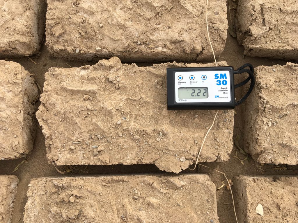
During the first geophysical campaign, we conducted spotty magnetic susceptibility measurements on our sites as well as the environment. Therefore, we used the handheld Kappameter SM-30 (Zh-instruments, Fig. 2). While magnetometry is a passive method, magnetic susceptibility meter are active instruments with a small coil included. Sampling the scattered rocks and archaeological objects like mudbricks gives an idea what we can expect in the magnetogram. Furthermore, the method can be applied in excavation trenches e.g. to distinguish stratigraphic layers or walls/floors and susceptibility maps can be produced. Due to magnetic susceptibility it is feasible to differentiate sources of raw material e.g. for mudbricks.
Figure 2: Measuring the magnetic volume susceptibility of a mudbrick laid out in the sun for drying with the Kappameter SM-30, showing a value of 2.22 [10-3 SI] (M. Scheiblecker).
For the settlement site GiE 001 at Ginis East, the scattered rock material shows mostly susceptibility values in a range of 0,302 to 0,826 [10-3 SI], esp. quartz, schist, and sedimentary rocks, while rocks of volcanic origin result in values around 7,5 [10-3 SI]. The surface values are ranging between 4,35 to 5,6 [10-3 SI] and mudbrick from a partly upright standing hut shows values of around 4 [10-3 SI]. For this site, we could expect therefore the following: walls made of sedimentary rocks would cause negative anomalies in the magnetogram, while the use of volcanic rock would result in positive anomalies. Mudbrick or galus walls (of stamped mud) are more difficult to predict; depending on their mineral composition, they are revealing positive or negative anomalies. Fire installations or the use of fired bricks would be easily recognizable because of their high values.
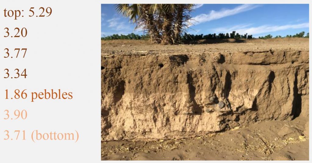
A profile along a street close to the Nile River shows the different sedimentation layers very nicely: different colours as well as susceptibility values can be seen in Figure 3.
Figure 3: Magnetic susceptibility values (in 10-3 SI) of a profile next to the Nile (M. Scheiblecker).
This example shows the complexity of magnetic susceptibility in combination with colours; darker and brighter layers show similar values, whereas the surface reaches the highest value. The layer with pebbles reveals the lowest value due to the included pebbles of probably sedimentary origin. For understanding the environment of archaeological sites and their formation processes, it is important to consider not only the survey, excavation and magnetometry results itself. Furthermore, knowledge in geology, geomorphology as well as the investigation of their parameters add details for a comprehensive picture of an archaeological landscape.
At the end, if you are asking yourself how magnetizable you are: without any ferromagnetic items from your clothes or e.g. glasses, the magnetic susceptibility would be almost zero or even negative, as the human body consists mostly of water.
References
Aspinall, A.; Gaffney, C.F.; Schmidt, A. (2008): Magnetometry for Archaeologists. Geophysical methods for archaeology 2. Lanham: AltaMira Press.
Butler, R.F. (1998): Paleomagnetism: Magnetic Domains to Geologic Terranes: Electronic Edition. Boston: Blackwell.
Dalan, R. (2017): Susceptiblity. In: Allan S. Gilbert, Paul Goldberg, Vance T. Holliday, Rolfe D. Mandel and Robert Siegmund Sternberg (eds.): Encyclopedia of Geoarchaeology. Dordrecht: Springer Reference (Encyclopedia of Earth Sciences Series), 939–944.
Fassbinder, J.W.E.; Stanjek, H.; Vali, H. (1990): Occurrence of Magnetic Bacteria in Soil. Nature 343 (6254), 161–163.
Fassbinder, Jörg W. E. (2017): Magnetometry for Archaeology. In: Allan S. Gilbert, Paul Goldberg, Vance T. Holliday, Rolfe D. Mandel and Robert Siegmund Sternberg (eds.): Encyclopedia of Geoarchaeology. Dordrecht: Springer Reference (Encyclopedia of Earth Sciences Series), 499–514.
Lowrie, W. (2007): Fundamentals of Geophysics, Cambridge: Cambridge University Press.