In recent decades, Egyptology and Sudan Archaeology have undergone some long needed substantial changes – through a gradual shift in perspective, Nubia’s cultures, long disparaged as copies of the “superior” Egyptian one, were finally acknowledged as what they were – clearly distinct and independent cultures in their own right, reflecting the extraordinarily long and rich cultural history of Nubia, the region of the Middle Nile valley.
A deeper questioning of the views of early researchers, who – bound to their zeitgeist – shaped Nubia’s allegedly inferior image for a long time, took already place in the 1980s and 1990s (see f.ex. the important articles by Adams 1981 and Trigger 1994). Trigger for example excellently analysed the influence of the circumstances of respective times on colonial and post-colonial archaeology. Furthermore, researchers like Charles Bonnet and also my own teacher, Steffen Wenig at the Humboldt Universität zu Berlin, who introduced me to the uniqueness of the Nubian cultures, worked hard to correct the out-dated picture of earlier times – laying the foundation, on which we continue to build.
And in fact, the scientific community of today has not only become aware of the dangers of Egyptocentric approaches towards Nubia, but is also including other long neglected topics such as gender archaeology (see f.ex. Minor 2018). However – and as usual – there is still a need for further optimisation in various areas.
Today, I would like to shed light on a sensitive aspect within our scientific work – namely the language we use in relation to Nubia, here by the example indigenous (resp. indigeneity). This term was, opposed to previous colonial mind-sets, introduced to distinguish and emphasise the unique character of Nubian cultures compared to Egyptian ones (e.g. already by Trigger 1994: 343).
In this sense indigenous was and isclearlyused with only good intentions – it however poses problems on two interrelated levels, which I would like to discuss firstly by looking at the term „indigenous“ in its modern use and secondly by presenting its controversial debate in this context. It is precisely this critical discussion that, as you will see in the following, mostly affected my discomfort in applying this term on past Nubian societies as well.
As first and surely minor problem to be mentioned is the (in the general understanding) primary (and not entirely congruent) association of indigenous with Australia’s and North America’s First Nations, as the term firstly emerged in the 1970s out of the American Indian Movement and the Canadian Indian Brotherhood. In this respect indigenous was explicitly chosen by their leaders – as a way of a clear self-identification as well as to unite those peoples for a better representation in international and political arenas such as the United Nations (Tuhiwai Smith 1999: 7).
That indigenous now encompasses modern First Nations in an international or global context dates back in the 1980s, when a specific definition of the term was developed by the UN (J.M. Cobo):
Indigenous peoples (…) are those which, having a historical continuity with pre-invasion and pre-colonial societies (…), consider themselves distinct from other sectors of the societies now prevailing in those territories (…). They form at present non-dominant sectors of society and are determined to preserve (…) to future generations their ancestral territories, and their ethnic identity, (…) in accordance with their own cultural patterns, social institutions and legal systems. (Cobo 1983: E/CN.4 Sub.2 /1983/21/Add.8; see also Klenke & Socha 2013: 33).
Astonishingly, it than still took two decades until the UN-Resolution “Declaration on the Rights of Indigenous“ was adopted by the General Assembly in 2007 defining the framework for the survival and well-being of indigenous peoples all over the world – being the today most comprehensive global instrument for their rights.
While clearly being an urgently needed step in the right direction, the modern use of indigenous is – quite understandably, as you will see below – subject ofon-going debates, not only in the scientific but also in the concerned communities themselves.
The criticism is manifold, starting already at a rather general level, where f.ex. researchers like Tuhiwai Smith point out the problematic indeterminacy of the term which seems “to collectivize many distinct populations whose experiences under imperialism have been vastly different.” (Tuhiwai Smith 1999: 6).
But also in fields like ethnology and cultural anthropology, the term indigeneity resp. the need of its clear differentiation of the (similar but not equal) concept of ethnicity (both as a practice of negotiating social identity) has led to many controversial discussions. Since a more detailed presentation of this highly interesting topic would request another blog, only the two most opposite poles are touched in the following and further readings recommended here (f.ex. contra: Kuper 2003 and 2005; pro: Kenrick & Lewis 2004): Thus, the harshest critics complain that the term’s underlying linkage of territory, culture, history, and descent would evoke associations of primordiality and essentialist identity – an opinion sharply rejected by others, seeing in such implied racist components a colonial undermining and further intensification of the struggles of First Nations (see detailed Klenke & Socha 2013: 30–33).
However, besides this discussion and not least in regard of the role ethnology and cultural anthropology played within colonialism (f.ex. defining ethnic groups for easier administration of colonised regions), there is a general consent to emphasise the aspect of self-definition as most significant criterion in this question (Klenke & Socha 2013: 31).
It is this precisely criterion – self-definition – that leads to my problems in using the term indigenous for ancient societies as those of Ancient Nubiaas well as for modern ones – as the term clearly bears the label of being an external attribution and not a self-defined one. And indeed, concerned peoples themselves are well aware of this problematic connotation, as it was f.ex. recently clearly put into words by the “Indigenous Foundations” (University of British Columbia) themselves:
“Although the term ‘Indigenous’ may be considered to be the most inclusive term of all, (….) it could be also seen as a contentious term, since it defines groups primarily in relation to their colonizers”.
(https://indigenousfoundations.arts.ubc.ca/aboriginal_identity__terminology/; on the question “Who speaks for whom?” see also Sillar 2005: 90–92).
All these aspects shown here clearly illustrate that also in modern discourses the search for a satisfactory solution for an adequate and autonomous terminology concerning modern First Nations is not at all finished yet.
The argument of self-definition mentioned above however is just as valid when dealing with past societies, in our case within Egyptology. Whereas no Egyptologist would use the term indigenous in context of the conquest of Egypt by the Nubian 25th Dynasty (would a sentence such as “Piye subdued the indigenous people of Thebes/Upper Egypt” not sound quite unfamiliar?), it is very often applied when addressing f.ex. the Kingdom of Kerma or the later Kingdom of Kush.
But, although well intentioned, in labelling Nubia’s ancient cultures as indigenous the same external perspective is expressed that was criticised above, in this case on Ancient Nubian peoples and their very own territories – even implying their subaltern position in relation to “their” Egyptian conquerors. Thus, this term evokes the uncomfortable feeling of an (unconscious) continuation of colonial stereotypes, just in a different guise – be they ancient or modern. And it is precisely these implications that bring us back to the point of an anachronistic Egyptocentric perspective that we are, after all, trying to overcome.
In this sense, such negative implications clearly illustrate, that, in all of the efforts to optimise our approach to Ancient Nubia, also the used terminology and language should continuously examined, especially since it can cause so much harm – as Tucholsky excellently stated in his famous bon mot „Language is like a weapon“.
With reflecting our terminology by f.ex. avoiding the term indigenous,also a self-reflection of our own perspectives can be further enhanced – why not adopt this time, not entirely but wisely, kind of a “Nubiocentric” stance? After all – there is no need to classify the Nubian cultures/peoples as indigenous, there is no need to define them in relation to Egypt – why not addressing them as what they are?: As Nubian peoples or cultures in their own right and in their own territories – as Kerma people of the strong Kingdom of Kerma, as Kushites of the powerful Kingdom of Kush, and so on and on…
Certainly there are grey areas, especially when dealing with periods of stronger interconnections between Nubians and Egyptians, like the New Kingdom Colonial Period.
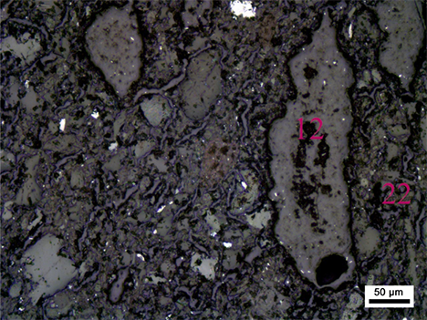
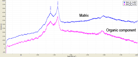
In this context, the DiverseNile project is perfectly suited for new directions, developing and applying new and better alternatives (see f.ex. the terms Nubian-style and Egyptian-style for vessels locally produced in Nubia, introduced and used by our PI Julia Budka and my colleague Giulia D’Ercole, New research goals at the time of Covid-19. Testing Raman Spectroscopy on Nubian and Egyptian-style pots) – thus further contributing to the still needed advocacy, Nubia’s ancient cultures need and deserve.
With these thoughts – which also go to the Sudanese people in these difficult times – I would like to conclude here and invite everyone interested to further discuss these important questions, also beyond the example chosen today, here with us in this space!
References
Adams, W.Y. 1981. Paradigms in Sudan Archaeology, in: Africa Today 28(2), 15–24.
Cobo, J.R.M. 1983. Study of the Problem of Discrimination against Indigenous Peoples. Final report submitted by the Special Rapporteur, Mr. José Martínez Cobo. https://www.un.org/development/desa/indigenouspeoples/publications/martinez-cobo-study.html
Kenrick, J. and Lewis, J. 2004. Indigenous Peoples’s Rights and the Politics of the Term “Indigenous”, in: Anthropology Today 20(2), 4–9.
Klenke, K. and Socha, P. 2013, Emerging Indigeneity – Völkerrechtswissenschaft und ethnologische Praxis subnationaler kultureller Gemeinschaften, in: Bizer, K. et al. (eds). Sui generis. Rechte zum Schutz traditioneller kultureller Ausdrucksweisen. Göttinger Studien zu Cultural Property 5, Göttingen: Universitätsverlag Göttingen, 21–42.
Kuper, A. 2003. The Return of the Native, in: Current Anthropology 44, 389–402.
– 2005. The Reinvention of Primitive Society. Transformations of a Myth. New York: Routledge.
Minor, E. 2018. Decolonizing Reisner: the Case Study of a Classic Kerma Female Burial for Reinterpreting Early Nubian Archaeological Collections through Digital Archival Resources, in: Honegger, M. (ed.), Nubian Archaeology in the XXIst Century: Proceedings of the Thirteenth International Conference for Nubian Studies, Neuchâtel, 1st–6th September 2014. Orientalia Lovaniensia Analecta 273. Leuven: Peeters, 251–262.
Sillar, B. 2005. Who’s indigenous? Whose archaeology?, in: Public Archaeology 4(2–3), 71–94.
Trigger, B.G. 1994. Paradigms in Sudan Archaeology, in: The International Journal of African Historical Studies 27(2), 323–345.
Tuhiwai Smith, L. 1999. Decolonizing Methodologies: Research and Indigenous Peoples. London: Zed Books.